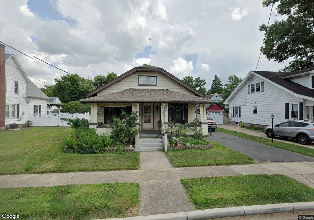
10 Maple St Franklin, OH 45005
Estimated Value: $174,000 - $198,000
3
Beds
2
Baths
1,334
Sq Ft
$140/Sq Ft
Est. Value
About This Home
This home is located at 10 Maple St, Franklin, OH 45005 and is currently estimated at $186,628, approximately $139 per square foot. 10 Maple St is a home located in Warren County with nearby schools including Franklin High School.
Ownership History
Date
Name
Owned For
Owner Type
Purchase Details
Closed on
Feb 5, 2026
Sold by
Singleton Christopher F and Randall Vickie S
Bought by
Runge Steven M
Current Estimated Value
Purchase Details
Closed on
Jan 10, 1989
Sold by
Mid*America Federal Savin
Bought by
Singleton Singleton and Singleton William W
Purchase Details
Closed on
Sep 1, 1988
Sold by
Miller Miller and Miller Ernie L
Bought by
Mid*America Federal Savin
Purchase Details
Closed on
Jun 27, 1984
Sold by
Crawford Crawford and Crawford Clara E
Bought by
Miller Miller and Miller Ernie L
Purchase Details
Closed on
Jul 2, 1982
Sold by
Blanken Blanken and Blanken Betty J
Purchase Details
Closed on
Nov 4, 1980
Sold by
Rose Rose and Rose Vernon H
Purchase Details
Closed on
Aug 4, 1978
Sold by
Rose Rose and Rose Myrtle K
Create a Home Valuation Report for This Property
The Home Valuation Report is an in-depth analysis detailing your home's value as well as a comparison with similar homes in the area
Home Values in the Area
Average Home Value in this Area
Purchase History
| Date | Buyer | Sale Price | Title Company |
|---|---|---|---|
| Runge Steven M | $175,000 | None Listed On Document | |
| Singleton Singleton | $42,000 | -- | |
| Mid*America Federal Savin | $39,000 | -- | |
| Miller Miller | $44,000 | -- | |
| -- | -- | -- | |
| -- | $41,000 | -- | |
| -- | -- | -- |
Source: Public Records
Tax History
| Year | Tax Paid | Tax Assessment Tax Assessment Total Assessment is a certain percentage of the fair market value that is determined by local assessors to be the total taxable value of land and additions on the property. | Land | Improvement |
|---|---|---|---|---|
| 2025 | $2,224 | $52,770 | $9,850 | $42,920 |
| 2024 | $2,224 | $52,770 | $9,850 | $42,920 |
| 2023 | $1,814 | $41,275 | $6,517 | $34,758 |
| 2022 | $1,781 | $41,276 | $6,517 | $34,759 |
| 2021 | $1,694 | $41,276 | $6,517 | $34,759 |
| 2020 | $1,449 | $33,016 | $5,212 | $27,804 |
| 2019 | $1,328 | $33,016 | $5,212 | $27,804 |
| 2018 | $1,330 | $33,016 | $5,212 | $27,804 |
| 2017 | $1,404 | $32,291 | $5,173 | $27,118 |
| 2016 | $1,429 | $32,291 | $5,173 | $27,118 |
| 2015 | $1,429 | $32,291 | $5,173 | $27,118 |
| 2014 | $1,343 | $32,290 | $5,170 | $27,120 |
| 2013 | $1,153 | $36,160 | $5,790 | $30,370 |
Source: Public Records
Map
Nearby Homes
- 414 Lake Ave
- 1512 Knightsbridge Ct
- 410 Park Ave
- 533 Spring Ave
- 3 Chestnut St
- 5 S River St
- 509 Forest Ave
- 511 Forest Ave
- 616 Lake Ave
- 712 Abney Ln
- 730 Park Ave
- 231 Lynn St
- 0 E 4th St
- 202 E 2nd St
- 0 Victoria Dr Unit 942075
- 0 Victoria Dr Unit 1852824
- 614 S River St
- 626 W Cresent Ln
- 626 W Crescent Ln
- 1200 Riley Blvd
Your Personal Tour Guide
Ask me questions while you tour the home.