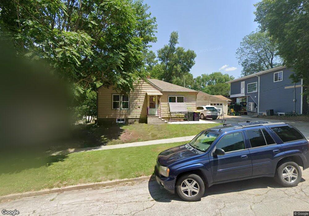
10 N Maple St Colfax, IA 50054
Estimated Value: $152,000 - $173,000
2
Beds
1
Bath
1,084
Sq Ft
$150/Sq Ft
Est. Value
About This Home
This home is located at 10 N Maple St, Colfax, IA 50054 and is currently estimated at $162,635, approximately $150 per square foot. 10 N Maple St is a home located in Jasper County with nearby schools including Colfax-Mingo Elementary School and Colfax-Mingo High School.
Ownership History
Date
Name
Owned For
Owner Type
Purchase Details
Closed on
Dec 21, 2021
Sold by
Houseman Desirae and Pierce Desirae
Bought by
Pierce Desirae
Current Estimated Value
Home Financials for this Owner
Home Financials are based on the most recent Mortgage that was taken out on this home.
Original Mortgage
$67,438
Interest Rate
4.16%
Mortgage Type
New Conventional
Purchase Details
Closed on
May 10, 2007
Sold by
Sheets Eric T
Bought by
Houseman Desirae
Home Financials for this Owner
Home Financials are based on the most recent Mortgage that was taken out on this home.
Original Mortgage
$82,425
Interest Rate
6.27%
Mortgage Type
New Conventional
Create a Home Valuation Report for This Property
The Home Valuation Report is an in-depth analysis detailing your home's value as well as a comparison with similar homes in the area
Purchase History
| Date | Buyer | Sale Price | Title Company |
|---|---|---|---|
| Pierce Desirae | -- | Servicelink | |
| Houseman Desirae | $83,000 | None Available |
Source: Public Records
Mortgage History
| Date | Status | Borrower | Loan Amount |
|---|---|---|---|
| Previous Owner | Pierce Desirae | $67,438 | |
| Previous Owner | Houseman Desirae | $82,425 |
Source: Public Records
Tax History
| Year | Tax Paid | Tax Assessment Tax Assessment Total Assessment is a certain percentage of the fair market value that is determined by local assessors to be the total taxable value of land and additions on the property. | Land | Improvement |
|---|---|---|---|---|
| 2025 | $2,026 | $130,650 | $14,740 | $115,910 |
| 2024 | $2,026 | $116,650 | $14,740 | $101,910 |
| 2023 | $2,036 | $116,650 | $14,740 | $101,910 |
| 2022 | $1,886 | $94,220 | $14,740 | $79,480 |
| 2021 | $1,954 | $92,990 | $14,740 | $78,250 |
| 2020 | $1,954 | $90,500 | $10,310 | $80,190 |
| 2019 | $1,756 | $78,190 | $0 | $0 |
| 2018 | $1,756 | $78,190 | $0 | $0 |
| 2017 | $1,734 | $78,190 | $0 | $0 |
| 2016 | $1,734 | $78,470 | $0 | $0 |
| 2015 | $1,724 | $78,470 | $0 | $0 |
| 2014 | $1,642 | $78,470 | $0 | $0 |
Source: Public Records
Map
Nearby Homes
- 205 E Division St
- 200 Jefferson St
- 222 E Broadway St
- 108 S Walnut St
- 226 S Iowa St
- 214 S Lincoln St
- 221 Cherry St
- 300 E Front St
- 238 S Walnut St
- 110 W Broadway St
- 655 E Division St
- 400 S Goodrich St
- 215 W Spring St
- 000 College Ave
- 501 W Broadway St
- 17 S Kelly St
- 10114 S 34th Ave W
- 1132 S Goodrich St
- 1161 S Goodrich St
- 11213 Orchard Ave
- 2 N Maple St
- 16 N Maple St
- 212 E Division St
- 203 Jefferson St
- 122 E Division St
- 209 Jefferson St
- 15 N Maple St
- 224 E Division St
- 215 E Division St
- 215 E Division St Unit A
- 206 Jefferson St
- 130 E Washington St
- 225 E Division St
- 127 E Howard St
- 227 E Howard St
- 125 E Howard St
- 306 E Division St
- 301 Jefferson St
- 103 E Division St
- 10 N Elm St
Your Personal Tour Guide
Ask me questions while you tour the home.