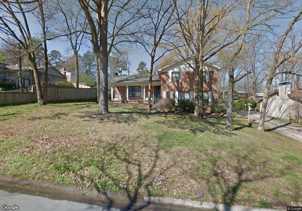
10 Nob View Cir Little Rock, AR 72205
Midtown Little Rock NeighborhoodEstimated Value: $285,845 - $303,000
--
Bed
4
Baths
2,028
Sq Ft
$145/Sq Ft
Est. Value
About This Home
This home is located at 10 Nob View Cir, Little Rock, AR 72205 and is currently estimated at $294,961, approximately $145 per square foot. 10 Nob View Cir is a home located in Pulaski County with nearby schools including Brady Elementary School, J.A. Fair K8 Preparatory School, and Henderson Middle School.
Ownership History
Date
Name
Owned For
Owner Type
Purchase Details
Closed on
Aug 29, 2007
Sold by
Wilson Darrick and Wilson Julie
Bought by
Kirby Adam A and Kirby Jennie T
Current Estimated Value
Home Financials for this Owner
Home Financials are based on the most recent Mortgage that was taken out on this home.
Original Mortgage
$154,800
Outstanding Balance
$98,312
Interest Rate
6.72%
Mortgage Type
Purchase Money Mortgage
Estimated Equity
$196,649
Purchase Details
Closed on
Jul 19, 2002
Sold by
Ross Shree Lynn and Marian Q Ross Revocable Trust
Bought by
Wilson Darrick and Wilson Julie
Home Financials for this Owner
Home Financials are based on the most recent Mortgage that was taken out on this home.
Original Mortgage
$140,600
Interest Rate
6.69%
Mortgage Type
Purchase Money Mortgage
Purchase Details
Closed on
Apr 1, 1998
Sold by
Ross Marian Q
Bought by
Ross Marian Q
Create a Home Valuation Report for This Property
The Home Valuation Report is an in-depth analysis detailing your home's value as well as a comparison with similar homes in the area
Home Values in the Area
Average Home Value in this Area
Purchase History
| Date | Buyer | Sale Price | Title Company |
|---|---|---|---|
| Kirby Adam A | $194,000 | Pulaski County Title | |
| Wilson Darrick | $148,000 | West Little Rock Title Compa | |
| Ross Marian Q | -- | -- |
Source: Public Records
Mortgage History
| Date | Status | Borrower | Loan Amount |
|---|---|---|---|
| Open | Kirby Adam A | $154,800 | |
| Previous Owner | Wilson Darrick | $140,600 |
Source: Public Records
Tax History Compared to Growth
Tax History
| Year | Tax Paid | Tax Assessment Tax Assessment Total Assessment is a certain percentage of the fair market value that is determined by local assessors to be the total taxable value of land and additions on the property. | Land | Improvement |
|---|---|---|---|---|
| 2025 | $3,234 | $46,202 | $9,000 | $37,202 |
| 2024 | $3,021 | $46,202 | $9,000 | $37,202 |
| 2023 | $3,021 | $46,202 | $9,000 | $37,202 |
| 2022 | $2,883 | $46,202 | $9,000 | $37,202 |
| 2021 | $2,766 | $39,230 | $9,100 | $30,130 |
| 2020 | $2,371 | $39,230 | $9,100 | $30,130 |
| 2019 | $2,303 | $39,230 | $9,100 | $30,130 |
| 2018 | $2,212 | $39,230 | $9,100 | $30,130 |
| 2017 | $2,096 | $39,230 | $9,100 | $30,130 |
| 2016 | $2,330 | $33,280 | $7,800 | $25,480 |
| 2015 | $2,333 | $33,280 | $7,800 | $25,480 |
| 2014 | $2,333 | $33,280 | $7,800 | $25,480 |
Source: Public Records
Map
Nearby Homes
- 22 Nob View Cir
- 3 Edgestone Dr
- 22 Nob Hill Cove
- 7 Brookfield Cove
- 1204 Fawnwood Rd
- 814 Shea Dr
- 10 Stoney Brook Ct
- 515 Brookside Dr
- 36 Flintwood Dr
- 7309 Gable Dr
- 24 Evergreen Ct
- 307 Sunnymeade Dr
- 7520 M St
- 7616 Briarwood Cir
- 1423 N Mississippi St
- 7505 N St
- 7303 L St
- 621 Mcadoo St
- 73 Reservoir Heights Dr
- 419 Carpenter Dr