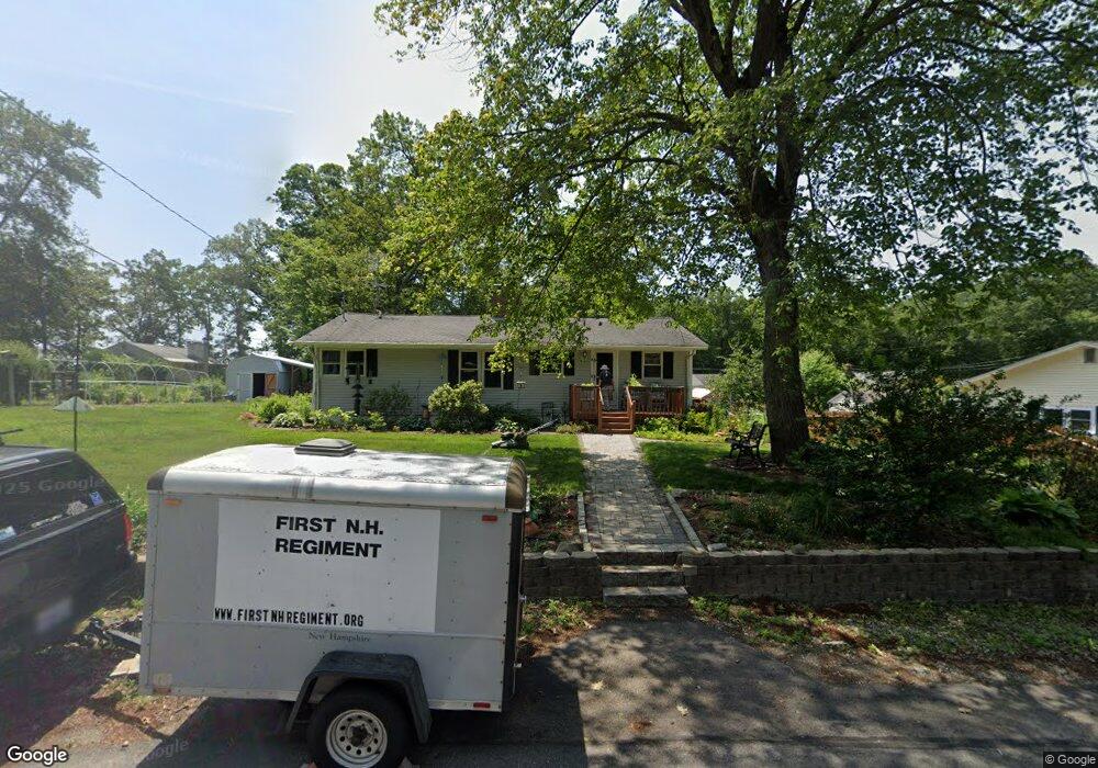
10 Oak Ridge Ave MerriMacK, NH 03054
Estimated Value: $437,919 - $501,000
3
Beds
2
Baths
1,610
Sq Ft
$294/Sq Ft
Est. Value
About This Home
This home is located at 10 Oak Ridge Ave, MerriMacK, NH 03054 and is currently estimated at $473,980, approximately $294 per square foot. 10 Oak Ridge Ave is a home located in Hillsborough County with nearby schools including Reeds Ferry School, James Mastricola Upper Elementary School, and Merrimack Middle School.
Ownership History
Date
Name
Owned For
Owner Type
Purchase Details
Closed on
Jul 11, 2006
Sold by
Faux Timothy J and Faux Jessica F
Bought by
Pearson Carol Ann
Current Estimated Value
Home Financials for this Owner
Home Financials are based on the most recent Mortgage that was taken out on this home.
Original Mortgage
$220,000
Interest Rate
6.6%
Mortgage Type
Purchase Money Mortgage
Purchase Details
Closed on
Aug 31, 2001
Sold by
Bourgeois Gerald D
Bought by
Faux Timothy J and Faux Jessica F
Create a Home Valuation Report for This Property
The Home Valuation Report is an in-depth analysis detailing your home's value as well as a comparison with similar homes in the area
Home Values in the Area
Average Home Value in this Area
Purchase History
| Date | Buyer | Sale Price | Title Company |
|---|---|---|---|
| Pearson Carol Ann | $275,000 | -- | |
| Faux Timothy J | $159,900 | -- |
Source: Public Records
Mortgage History
| Date | Status | Borrower | Loan Amount |
|---|---|---|---|
| Open | Faux Timothy J | $194,045 | |
| Closed | Faux Timothy J | $212,800 | |
| Closed | Faux Timothy J | $25,000 | |
| Closed | Faux Timothy J | $220,000 |
Source: Public Records
Tax History Compared to Growth
Tax History
| Year | Tax Paid | Tax Assessment Tax Assessment Total Assessment is a certain percentage of the fair market value that is determined by local assessors to be the total taxable value of land and additions on the property. | Land | Improvement |
|---|---|---|---|---|
| 2024 | $6,304 | $304,700 | $157,600 | $147,100 |
| 2023 | $5,687 | $292,400 | $157,600 | $134,800 |
| 2022 | $5,082 | $292,400 | $157,600 | $134,800 |
| 2021 | $5,021 | $292,400 | $157,600 | $134,800 |
| 2020 | $5,086 | $211,400 | $108,400 | $103,000 |
| 2019 | $5,099 | $211,300 | $108,400 | $102,900 |
| 2018 | $5,097 | $211,300 | $108,400 | $102,900 |
| 2017 | $4,938 | $211,300 | $108,400 | $102,900 |
| 2016 | $4,852 | $212,900 | $110,000 | $102,900 |
| 2015 | $4,969 | $201,000 | $105,000 | $96,000 |
| 2014 | $4,842 | $201,000 | $105,000 | $96,000 |
| 2013 | $4,806 | $201,000 | $105,000 | $96,000 |
Source: Public Records
Map
Nearby Homes
- 12 Clinton Ct
- 20 Essex Green Ct
- 19 Vista Way
- 6 Stearns Ln Unit 202
- 2 Killian Ct
- 2 Bishop St
- 87 Indian Rock Rd
- 79 Indian Rock Rd
- 12 Sandhill Dr
- 12 Davis Rd
- 80 Wire Rd
- 29 Bedford Rd
- 16 Penacook Terrace
- 343 Charles Bancroft Hwy
- 5 Barbie Ct
- 6 Oak St
- 1 Tallarico St Unit 2
- 1 Tallarico St Unit 14
- 17 Echo Shore Dr
- 0 Tallarico St Unit Lot 11 5056385
- 12 Oak Ridge Ave
- 8 Oak Ridge Ave
- 20 Bel Aire Ave
- 11 Oak Ridge Ave
- 9 Oak Ridge Ave
- 18 McGaw Bridge Rd
- 15 Oak Ridge Ave
- 20 McGaw Bridge Rd
- 16 McGaw Bridge Rd
- 6 Oak Ridge Ave
- 17 Bel Aire Ave
- 16 Bel Aire Ave
- 14 McGaw Bridge Rd
- 7 Oak Ridge Ave
- 2 Oak Ridge Ave
- 15 Bel Aire Ave
- 14 Bel Aire Ave
- 6 Sunnydale Dr
- 5 Oak Ridge Ave
- 8 Sunnydale Dr