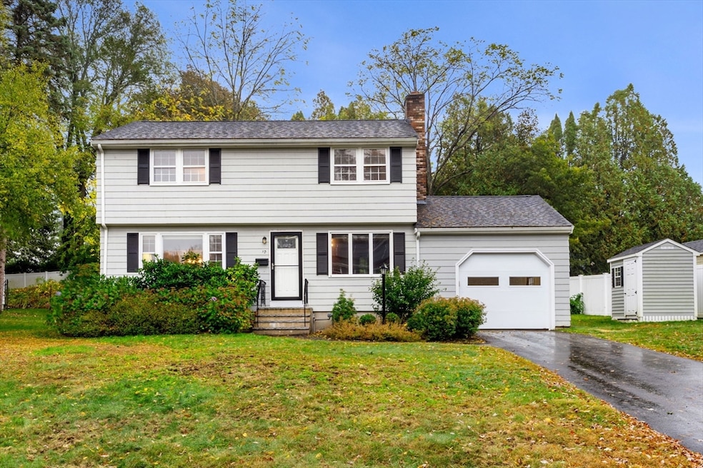
10 Rawson Hill Rd Newburyport, MA 01950
Estimated payment $5,376/month
Highlights
- Marina
- Golf Course Community
- Medical Services
- Newburyport High School Rated A-
- Community Stables
- Colonial Architecture
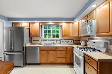
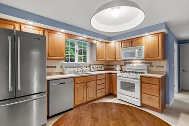
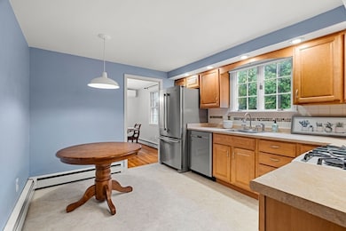
About This Home
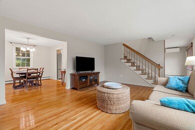
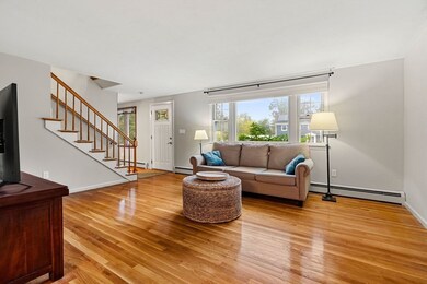
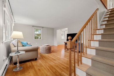
Charming 4-bedroom Colonial in one of Newburyport’s most desirable cul-de-sac neighborhoods—rarely available and just a short distance to downtown and all schools! Lovingly cared for by the same owners for 42 years, this home exudes pride of ownership inside and out. Gleaming hardwood floors flow throughout the home, which offers a classic layout with a spacious living room, dining room, family room, and kitchen, plus a convenient half bath with laundry on the first floor. Upstairs are four comfortable bedrooms and a full bath. The high-ceiling basement offers a large finished room as an additional bonus/playroom/office, along with storage and workshop space. Wood shingle exterior adds timeless curb appeal, and the generous yard provides plenty of space for outdoor enjoyment. A one-car garage completes this exceptional offering. Homes in this location seldom come on the market—don’t miss this special opportunity to make it yours! Open Houses Fri/Sat/Sun. Easy to show!
Home Details
Home Type
- Single Family
Est. Annual Taxes
- $7,640
Year Built
- Built in 1967
Lot Details
- 10,454 Sq Ft Lot
- Cul-De-Sac
Parking
- 1 Car Attached Garage
- Parking Storage or Cabinetry
- Tandem Parking
- Garage Door Opener
- Driveway
- Open Parking
- Deeded Parking
Home Design
- Colonial Architecture
- Frame Construction
- Shingle Roof
- Concrete Perimeter Foundation
Interior Spaces
- Window Screens
- Insulated Doors
- Family Room with Fireplace
- Bonus Room
Kitchen
- Range
- Microwave
- Dishwasher
Flooring
- Wood
- Vinyl
Bedrooms and Bathrooms
- 4 Bedrooms
- Primary bedroom located on second floor
- Bathtub with Shower
Laundry
- Laundry on main level
- Dryer
- Washer
Partially Finished Basement
- Basement Fills Entire Space Under The House
- Interior Basement Entry
Home Security
- Storm Windows
- Storm Doors
Outdoor Features
- Bulkhead
- Outdoor Storage
- Rain Gutters
Location
- Property is near public transit
- Property is near schools
Schools
- Bresnahan/Rvcs Elementary School
- Nock/Molin Middle School
- NHS High School
Utilities
- Ductless Heating Or Cooling System
- 6 Cooling Zones
- 3 Heating Zones
- Baseboard Heating
- 200+ Amp Service
- Gas Water Heater
Listing and Financial Details
- Assessor Parcel Number 2086889
Community Details
Overview
- No Home Owners Association
- Near Conservation Area
Amenities
- Medical Services
- Shops
Recreation
- Marina
- Golf Course Community
- Tennis Courts
- Community Pool
- Park
- Community Stables
- Jogging Path
- Bike Trail
Map
Home Values in the Area
Average Home Value in this Area
Tax History
| Year | Tax Paid | Tax Assessment Tax Assessment Total Assessment is a certain percentage of the fair market value that is determined by local assessors to be the total taxable value of land and additions on the property. | Land | Improvement |
|---|---|---|---|---|
| 2025 | $7,608 | $794,200 | $458,000 | $336,200 |
| 2024 | $7,335 | $735,700 | $416,300 | $319,400 |
| 2023 | $6,665 | $620,600 | $362,000 | $258,600 |
| 2022 | $6,485 | $540,000 | $301,700 | $238,300 |
| 2021 | $6,268 | $495,900 | $274,300 | $221,600 |
| 2020 | $6,236 | $485,700 | $274,300 | $211,400 |
| 2019 | $6,363 | $486,500 | $274,300 | $212,200 |
| 2018 | $6,049 | $456,200 | $261,200 | $195,000 |
| 2017 | $6,016 | $447,300 | $248,800 | $198,500 |
| 2016 | $5,578 | $416,600 | $226,700 | $189,900 |
| 2015 | $5,621 | $421,400 | $226,700 | $194,700 |
Property History
| Date | Event | Price | List to Sale | Price per Sq Ft |
|---|---|---|---|---|
| 10/21/2025 10/21/25 | Pending | -- | -- | -- |
| 10/15/2025 10/15/25 | For Sale | $900,000 | -- | $569 / Sq Ft |
Purchase History
| Date | Type | Sale Price | Title Company |
|---|---|---|---|
| Quit Claim Deed | -- | -- | |
| Deed | $104,000 | -- |
Mortgage History
| Date | Status | Loan Amount | Loan Type |
|---|---|---|---|
| Previous Owner | $12,122 | No Value Available |
Source: MLS Property Information Network (MLS PIN)
MLS Number: 73443807
APN: NEWP-000040-000011
Disclaimer: Certain information contained herein is derived from information provided by parties other than Homes.com. All information provided is deemed reliable, but is not guaranteed to be accurate and should be independently verified.
![]() The property listing data and information, or the Images, set forth herein were provided to MLS Property Information Network, Inc. from third party sources, including sellers, lessors and public records, and were compiled by MLS Property Information Network, Inc. The property listing data and information, and the Images, are for the personal, non-commercial use of consumers having a good faith interest in purchasing or leasing listed properties of the type displayed to them and may not be used for any purpose other than to identify prospective properties which such consumers may have a good faith interest in purchasing or leasing. MLS Property Information Network, Inc. and its subscribers disclaim any and all representations and warranties as to the accuracy of the property listing data and information, or as to the accuracy of any of the Images, set forth herein.
The property listing data and information, or the Images, set forth herein were provided to MLS Property Information Network, Inc. from third party sources, including sellers, lessors and public records, and were compiled by MLS Property Information Network, Inc. The property listing data and information, and the Images, are for the personal, non-commercial use of consumers having a good faith interest in purchasing or leasing listed properties of the type displayed to them and may not be used for any purpose other than to identify prospective properties which such consumers may have a good faith interest in purchasing or leasing. MLS Property Information Network, Inc. and its subscribers disclaim any and all representations and warranties as to the accuracy of the property listing data and information, or as to the accuracy of any of the Images, set forth herein.
- 287 1/2 High St
- 138 Low St
- 110 Low St
- 288 Merrimac St
- 42 Myrtle Ave
- 13 Broad St
- 17 Alberta Ave
- 27 Warren St Unit 1
- 217 Merrimac St Unit 1
- 266 Merrimac St Unit F
- 19 Jefferson St
- 182 Merrimac St Unit 1
- 14 Dexter Ln Unit A
- 158 Merrimac St Unit 3
- 45 Boardman St Unit 1
- 41 Washington St Unit B
- 44 Washington St Unit C
- 126 Merrimac St Unit 31
- 232 Low St Unit 7
- 492 Merrimac St
