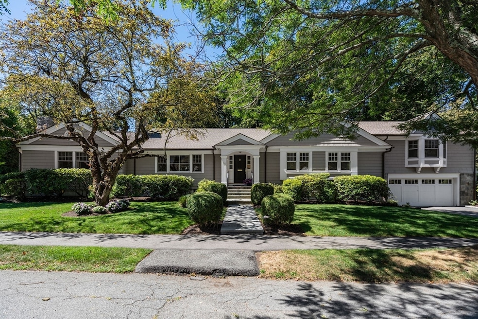
10 Ruane Rd West Newton, MA 02465
West Newton NeighborhoodEstimated payment $16,131/month
Highlights
- Golf Course Community
- Medical Services
- Open Floorplan
- Peirce Elementary School Rated A+
- Sauna
- Custom Closet System
About This Home
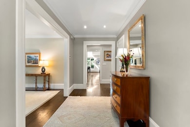
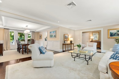
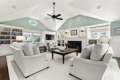
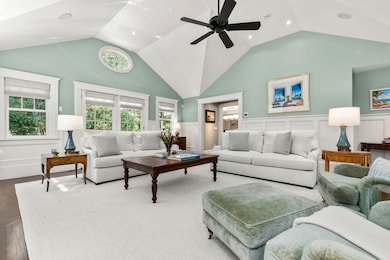
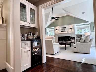
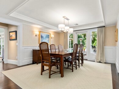
West Newton Hill: Move right in to this extraordinary home, beautifully renovated to the highest standard with an open, airy layout perfect for modern living. The chef’s kitchen is a true standout, featuring Calacatta Gold marble countertops, a leathered granite island, Sub-Zero refrigerator & wine refrigerator, Wolf double ovens with gas cooktop, and a Miele dishwasher, opening to a spacious Mahogany deck for seamless indoor-outdoor enjoyment. A spectacular family room offers the ideal space for gatherings, while the luxurious primary suite provides a private retreat with a spa-like bath and generous proportions. With four bedrooms and 3.5 baths across two levels, this meticulously maintained home combines sophistication with comfort. Highlights include a 2-car garage, sun-filled spaces, & exceptional attention to detail throughout. Ideally located near top schools, parks, and local amenities, this residence offers the perfect balance of convenience, luxury, & everyday livability.
Home Details
Home Type
- Single Family
Est. Annual Taxes
- $25,972
Year Built
- Built in 1953 | Remodeled
Lot Details
- 0.35 Acre Lot
- Corner Lot
- Sprinkler System
- Garden
- Property is zoned SR1
Parking
- 2 Car Attached Garage
- Garage Door Opener
- Driveway
- Open Parking
- Off-Street Parking
Home Design
- Contemporary Architecture
- Ranch Style House
- Frame Construction
- Shingle Roof
- Concrete Perimeter Foundation
Interior Spaces
- Open Floorplan
- Wet Bar
- Crown Molding
- Wainscoting
- Tray Ceiling
- Vaulted Ceiling
- Ceiling Fan
- Skylights
- Recessed Lighting
- Decorative Lighting
- Light Fixtures
- Insulated Windows
- Bay Window
- Picture Window
- Insulated Doors
- Living Room with Fireplace
- 3 Fireplaces
- Dining Area
- Game Room
- Sauna
- Home Security System
Kitchen
- Double Oven
- Range with Range Hood
- Microwave
- Plumbed For Ice Maker
- Dishwasher
- Wine Refrigerator
- Wolf Appliances
- Solid Surface Countertops
- Trash Compactor
- Disposal
Flooring
- Wood
- Wall to Wall Carpet
- Ceramic Tile
Bedrooms and Bathrooms
- 4 Bedrooms
- Custom Closet System
- Walk-In Closet
- Bathtub with Shower
- Bathtub Includes Tile Surround
- Separate Shower
Laundry
- Sink Near Laundry
- Washer and Gas Dryer Hookup
Finished Basement
- Basement Fills Entire Space Under The House
- Garage Access
- Sump Pump
- Laundry in Basement
Eco-Friendly Details
- Energy-Efficient Thermostat
Outdoor Features
- Bulkhead
- Deck
- Outdoor Storage
- Rain Gutters
Location
- Property is near public transit
- Property is near schools
Schools
- Peirce Elementary School
- Day Middle School
- North High School
Utilities
- Forced Air Heating and Cooling System
- 3 Cooling Zones
- 5 Heating Zones
- Heating System Uses Natural Gas
- Baseboard Heating
- Generator Hookup
- Power Generator
- Gas Water Heater
- High Speed Internet
Listing and Financial Details
- Assessor Parcel Number S:32 B:023 L:0001,687926
Community Details
Overview
- No Home Owners Association
- Near Conservation Area
Amenities
- Medical Services
- Shops
Recreation
- Golf Course Community
- Tennis Courts
- Community Pool
- Park
- Jogging Path
- Bike Trail
Map
Home Values in the Area
Average Home Value in this Area
Tax History
| Year | Tax Paid | Tax Assessment Tax Assessment Total Assessment is a certain percentage of the fair market value that is determined by local assessors to be the total taxable value of land and additions on the property. | Land | Improvement |
|---|---|---|---|---|
| 2025 | $25,972 | $2,650,200 | $1,309,000 | $1,341,200 |
| 2024 | $25,112 | $2,573,000 | $1,270,900 | $1,302,100 |
| 2023 | $23,917 | $2,349,400 | $991,500 | $1,357,900 |
| 2022 | $22,885 | $2,175,400 | $918,100 | $1,257,300 |
| 2021 | $22,083 | $2,052,300 | $866,100 | $1,186,200 |
| 2020 | $21,426 | $2,052,300 | $866,100 | $1,186,200 |
| 2019 | $0 | $1,992,500 | $840,900 | $1,151,600 |
| 2018 | $19,986 | $1,847,100 | $760,000 | $1,087,100 |
| 2017 | $19,377 | $1,742,500 | $717,000 | $1,025,500 |
| 2016 | $18,532 | $1,628,500 | $670,100 | $958,400 |
| 2015 | $17,670 | $1,522,000 | $626,300 | $895,700 |
Property History
| Date | Event | Price | List to Sale | Price per Sq Ft |
|---|---|---|---|---|
| 10/17/2025 10/17/25 | Pending | -- | -- | -- |
| 10/03/2025 10/03/25 | Price Changed | $2,650,000 | -11.5% | $603 / Sq Ft |
| 09/10/2025 09/10/25 | For Sale | $2,995,000 | -- | $682 / Sq Ft |
Purchase History
| Date | Type | Sale Price | Title Company |
|---|---|---|---|
| Deed | -- | -- | |
| Deed | -- | -- |
Source: MLS Property Information Network (MLS PIN)
MLS Number: 73429169
APN: NEWT-000032-000023-000001
Disclaimer: Certain information contained herein is derived from information provided by parties other than Homes.com. All information provided is deemed reliable, but is not guaranteed to be accurate and should be independently verified.
![]() The property listing data and information, or the Images, set forth herein were provided to MLS Property Information Network, Inc. from third party sources, including sellers, lessors and public records, and were compiled by MLS Property Information Network, Inc. The property listing data and information, and the Images, are for the personal, non-commercial use of consumers having a good faith interest in purchasing or leasing listed properties of the type displayed to them and may not be used for any purpose other than to identify prospective properties which such consumers may have a good faith interest in purchasing or leasing. MLS Property Information Network, Inc. and its subscribers disclaim any and all representations and warranties as to the accuracy of the property listing data and information, or as to the accuracy of any of the Images, set forth herein.
The property listing data and information, or the Images, set forth herein were provided to MLS Property Information Network, Inc. from third party sources, including sellers, lessors and public records, and were compiled by MLS Property Information Network, Inc. The property listing data and information, and the Images, are for the personal, non-commercial use of consumers having a good faith interest in purchasing or leasing listed properties of the type displayed to them and may not be used for any purpose other than to identify prospective properties which such consumers may have a good faith interest in purchasing or leasing. MLS Property Information Network, Inc. and its subscribers disclaim any and all representations and warranties as to the accuracy of the property listing data and information, or as to the accuracy of any of the Images, set forth herein.
- 68 Mignon Rd
- 18 Sewall St
- 222 Prince St
- 39 Valentine Park
- 443 Chestnut St
- 1639 Washington St
- 1488 Washington St Unit 1488
- 17 Gilbert St
- 12 Inis Cir
- 479 Chestnut St
- 0 Duncan Rd Unit 72925240
- 51 Bourne St
- 1754 Washington St
- 308 Prince St
- 163 Day St
- 513 Chestnut St
- 79 Chestnut St Unit 2
- 283 Woodland Rd
- 36 Troy Ln
- 115 Windsor Rd
