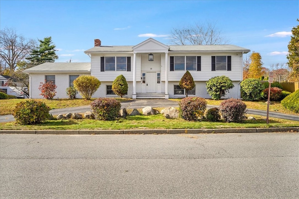
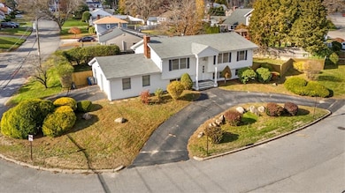
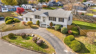
10 Sheffield Rd Cranston, RI 02920
Meshanticut NeighborhoodEstimated payment $3,602/month
Highlights
- Golf Course Community
- Deck
- Wood Flooring
- Cranston High School West Rated 9+
- Raised Ranch Architecture
- Attic
About This Home
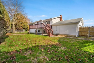
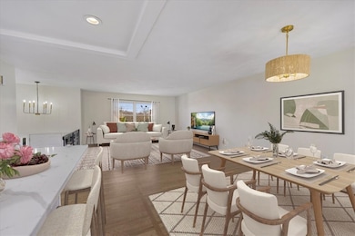
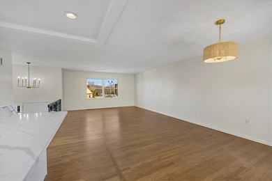
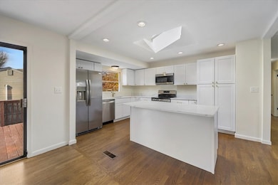
Move right in! This beautifully updated Raised Ranch in sought-after Woodridge offers 3 5 bedrooms, 3 full bathrooms, and a bright, open-concept layout perfect for modern living. The main level features a spacious living and dining area with gleaming hardwood floors throughout, flowing seamlessly into the newly renovated kitchen with brand-new cabinetry, stainless steel appliances, and granite countertops. Three generously sized bedrooms anchor the main floor, including a primary suite option, while all three full bathrooms in the home have been thoughtfully updated. The expansive lower level adds incredible versatility, offering two additional bedrooms, a large family room with a cozy fireplace and wet bar, and a third full bathroom ideal for extra living space, guest quarters, or excellent in-law potential. Set on a fenced, corner lot with irrigation, this home also includes central air, a two-car garage, and ample outdoor space for entertaining. Perfectly positioned between Garden City and Dean Estates, you'll enjoy unbeatable convenience to shopping, restaurants, parks, and highway access. Stylish, spacious, and move-in ready this Woodridge gem has it all.
Home Details
Home Type
- Single Family
Est. Annual Taxes
- $5,844
Year Built
- Built in 1976
Lot Details
- 0.27 Acre Lot
- Fenced
- Corner Lot
- Sprinkler System
- Property is zoned A8
Parking
- 2 Car Attached Garage
- Driveway
Home Design
- Raised Ranch Architecture
- Brick Exterior Construction
- Wood Siding
- Shingle Siding
- Concrete Perimeter Foundation
- Plaster
Interior Spaces
- 1-Story Property
- Wet Bar
- Fireplace Features Masonry
- Living Room
- Storage Room
- Utility Room
- Attic
Kitchen
- Oven
- Range
- Microwave
- Dishwasher
Flooring
- Wood
- Ceramic Tile
Bedrooms and Bathrooms
- 3 Bedrooms
- Cedar Closet
- 3 Full Bathrooms
- Bathtub with Shower
Finished Basement
- Walk-Out Basement
- Basement Fills Entire Space Under The House
Utilities
- Forced Air Heating and Cooling System
- Heating System Uses Gas
- Gas Water Heater
Additional Features
- Deck
- Property near a hospital
Listing and Financial Details
- Tax Lot 3477
- Assessor Parcel Number 10SHEFFIELDRDCRAN
Community Details
Overview
- Woodridge Subdivision
Amenities
- Shops
- Restaurant
- Public Transportation
Recreation
- Golf Course Community
- Recreation Facilities
Map
Home Values in the Area
Average Home Value in this Area
Tax History
| Year | Tax Paid | Tax Assessment Tax Assessment Total Assessment is a certain percentage of the fair market value that is determined by local assessors to be the total taxable value of land and additions on the property. | Land | Improvement |
|---|---|---|---|---|
| 2025 | $5,845 | $421,100 | $116,400 | $304,700 |
| 2024 | $5,731 | $421,100 | $116,400 | $304,700 |
| 2023 | $5,534 | $292,800 | $80,300 | $212,500 |
| 2022 | $5,420 | $292,800 | $80,300 | $212,500 |
| 2021 | $5,270 | $292,800 | $80,300 | $212,500 |
| 2020 | $5,724 | $275,600 | $84,100 | $191,500 |
| 2019 | $5,724 | $275,600 | $84,100 | $191,500 |
| 2018 | $5,592 | $275,600 | $84,100 | $191,500 |
| 2017 | $5,730 | $249,800 | $76,500 | $173,300 |
| 2016 | $5,608 | $249,800 | $76,500 | $173,300 |
| 2015 | $5,608 | $249,800 | $76,500 | $173,300 |
| 2014 | $5,125 | $224,400 | $76,500 | $147,900 |
Property History
| Date | Event | Price | List to Sale | Price per Sq Ft |
|---|---|---|---|---|
| 11/19/2025 11/19/25 | For Sale | $589,900 | -- | $268 / Sq Ft |
Purchase History
| Date | Type | Sale Price | Title Company |
|---|---|---|---|
| Deed | $390,000 | -- | |
| Deed | $390,000 | -- |
Mortgage History
| Date | Status | Loan Amount | Loan Type |
|---|---|---|---|
| Open | $375,000 | Purchase Money Mortgage | |
| Closed | $375,000 | New Conventional |
Source: State-Wide MLS
MLS Number: 1400299
APN: CRAN-000011-000006-003477
Disclaimer: Certain information contained herein is derived from information provided by parties other than Homes.com. All information provided is deemed reliable, but is not guaranteed to be accurate and should be independently verified.
![]() IDX information is provided exclusively for personal, non-commercial use, and may not be used for any purpose other than to identify prospective properties consumers may be interested in purchasing. Information is deemed reliable but not guaranteed.
IDX information is provided exclusively for personal, non-commercial use, and may not be used for any purpose other than to identify prospective properties consumers may be interested in purchasing. Information is deemed reliable but not guaranteed.
Copyright © 2025 State-Wide MLS, Inc. All rights reserved.
- 446 Budlong Rd
- 28 Hybrid Dr
- 141 Glen Ridge Rd
- 22 Franconia Dr
- 265 Knollwood Ave
- 37 Deerfield Rd
- 0 Rutland St
- 130 Fordson Ave Unit 3
- 132 Fordson Ave Unit 12
- 69 W View Ave
- 46 Lilyana Way
- 113 Fordson Ave
- 105 Fordson Ave
- 210 Hyde St
- 111 Belgium St
- 34 Keller Ave
- 51 E Bel Air Rd
- 64 White Birch Rd
- 16 Riverfarm Rd
- 200 Hoffman Ave Unit 505
- 41 Garden City Dr
- 430 Meshanticut Valley Pkwy
- 179 Kearney St Unit 1
- 91-111 Oaklawn Ave
- 30 Oaklawn Ave
- 58 Vale Ave
- 65-75 Oaklawn Ave
- 65 Oaklawn Ave Unit 75-114
- 201 Hoffman Ave Unit 25
- 16 Davis Ave Unit 1
- 825 Pontiac Ave
- 1809 Cranston St Unit 2
- 1 Dean St Unit 2
- 134 Flint Ave
- 108 Phenix Ave Unit 2
- 83 Phenix Ave Unit 83
- 85 Richard St Unit 2
- 85 Richard St
- 41 Oak St Unit 43
- 24 Elmhurst Ave Unit 2
