
Seller's Agent in 2026
Laurie Detwiler
William Raveis R.E. & Home Services
(781) 789-7974
31 in this area
71 Total Sales

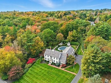
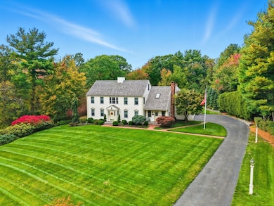


Home for the holidays! This updated colonial, a star in the neighborhood, has traditional lines but many surprises inside. Every space reflects care and quality, from the hardwood floors and abundant natural light to the seamless connection between indoor and outdoor living. The newly renovated kitchen with custom banquette opens to a spacious family and playroom area overlooking a wide private deck, landscaped yard, and beautiful saltwater pool — perfect for large gatherings. Upstairs, two immense primary suites provide flexibility, joined by two additional bedrooms and both front and back stairways. The walk-out lower level includes a gym, movie room, workshop, and excellent storage, supported by well-maintained systems including generator. A heated three-car garage with dual lifts, plumbing, and space for up to five vehicles offers an ideal setup for car enthusiasts or hobbyists. Putting green? Yes! Meticulous condition with a prime Norwell location, 26 miles south of Boston.
Last Agent to Sell the Property
William Raveis R.E. & Home Services Listed on: 10/23/2025
| Date | Type | Sale Price | Title Company |
|---|---|---|---|
| Quit Claim Deed | $1,600,000 | -- | |
| Quit Claim Deed | -- | None Available | |
| Quit Claim Deed | -- | None Available | |
| Deed | $585,000 | -- | |
| Deed | $585,000 | -- |
| Date | Status | Loan Amount | Loan Type |
|---|---|---|---|
| Previous Owner | $230,000 | No Value Available | |
| Previous Owner | $176,250 | No Value Available | |
| Previous Owner | $450,000 | Purchase Money Mortgage |
| Date | Event | Price | List to Sale | Price per Sq Ft |
|---|---|---|---|---|
| 01/09/2026 01/09/26 | Sold | $1,600,000 | -10.9% | $391 / Sq Ft |
| 11/26/2025 11/26/25 | Pending | -- | -- | -- |
| 11/07/2025 11/07/25 | Price Changed | $1,795,000 | -3.0% | $438 / Sq Ft |
| 10/23/2025 10/23/25 | For Sale | $1,850,000 | -- | $452 / Sq Ft |
| Year | Tax Paid | Tax Assessment Tax Assessment Total Assessment is a certain percentage of the fair market value that is determined by local assessors to be the total taxable value of land and additions on the property. | Land | Improvement |
|---|---|---|---|---|
| 2025 | $20,498 | $1,568,300 | $532,200 | $1,036,100 |
| 2024 | $20,078 | $1,491,700 | $502,200 | $989,500 |
| 2023 | $19,372 | $1,267,000 | $257,500 | $1,009,500 |
| 2022 | $19,379 | $1,166,000 | $273,500 | $892,500 |
| 2021 | $18,016 | $1,063,500 | $287,900 | $775,600 |
| 2020 | $7,738 | $1,088,400 | $293,100 | $795,300 |
| 2019 | $17,373 | $1,059,300 | $314,000 | $745,300 |
| 2018 | $16,760 | $1,025,700 | $287,900 | $737,800 |
| 2017 | $644 | $1,104,100 | $366,300 | $737,800 |
| 2016 | $17,140 | $1,038,800 | $327,100 | $711,700 |
| 2015 | $16,848 | $1,021,100 | $327,100 | $694,000 |
| 2014 | $16,336 | $997,900 | $357,200 | $640,700 |
Seller's Agent in 2026
Laurie Detwiler
William Raveis R.E. & Home Services
(781) 789-7974
31 in this area
71 Total Sales
Buyer's Agent in 2026
Lindsay Higgins
The Market
(857) 201-2461
1 in this area
15 Total Sales
Source: MLS Property Information Network (MLS PIN)
MLS Number: 73446958
APN: NORW-000072-000000-000082
Disclaimer: Certain information contained herein is derived from information provided by parties other than Homes.com. All information provided is deemed reliable, but is not guaranteed to be accurate and should be independently verified.
![]() The property listing data and information, or the Images, set forth herein were provided to MLS Property Information Network, Inc. from third party sources, including sellers, lessors and public records, and were compiled by MLS Property Information Network, Inc. The property listing data and information, and the Images, are for the personal, non-commercial use of consumers having a good faith interest in purchasing or leasing listed properties of the type displayed to them and may not be used for any purpose other than to identify prospective properties which such consumers may have a good faith interest in purchasing or leasing. MLS Property Information Network, Inc. and its subscribers disclaim any and all representations and warranties as to the accuracy of the property listing data and information, or as to the accuracy of any of the Images, set forth herein.
The property listing data and information, or the Images, set forth herein were provided to MLS Property Information Network, Inc. from third party sources, including sellers, lessors and public records, and were compiled by MLS Property Information Network, Inc. The property listing data and information, and the Images, are for the personal, non-commercial use of consumers having a good faith interest in purchasing or leasing listed properties of the type displayed to them and may not be used for any purpose other than to identify prospective properties which such consumers may have a good faith interest in purchasing or leasing. MLS Property Information Network, Inc. and its subscribers disclaim any and all representations and warranties as to the accuracy of the property listing data and information, or as to the accuracy of any of the Images, set forth herein.
Ask me questions while you tour the home.