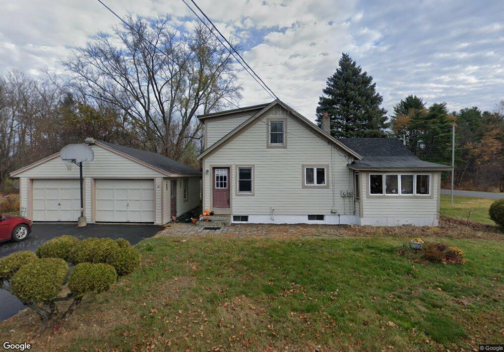
10 Snumshire Ln Charlestown, NH 03603
Estimated Value: $280,000 - $348,000
3
Beds
2
Baths
1,782
Sq Ft
$169/Sq Ft
Est. Value
About This Home
This home is located at 10 Snumshire Ln, Charlestown, NH 03603 and is currently estimated at $300,592, approximately $168 per square foot. 10 Snumshire Ln is a home located in Sullivan County with nearby schools including Charlestown Primary School, Charlestown Middle School, and Fall Mountain Regional High School.
Ownership History
Date
Name
Owned For
Owner Type
Purchase Details
Closed on
Jun 11, 2021
Sold by
Julie A Bacon Ret
Bought by
Grace Michael R and Lee Kara J
Current Estimated Value
Home Financials for this Owner
Home Financials are based on the most recent Mortgage that was taken out on this home.
Original Mortgage
$180,000
Outstanding Balance
$162,968
Interest Rate
2.9%
Mortgage Type
Purchase Money Mortgage
Estimated Equity
$137,624
Create a Home Valuation Report for This Property
The Home Valuation Report is an in-depth analysis detailing your home's value as well as a comparison with similar homes in the area
Home Values in the Area
Average Home Value in this Area
Purchase History
| Date | Buyer | Sale Price | Title Company |
|---|---|---|---|
| Grace Michael R | $200,000 | None Available |
Source: Public Records
Mortgage History
| Date | Status | Borrower | Loan Amount |
|---|---|---|---|
| Open | Grace Michael R | $180,000 |
Source: Public Records
Tax History Compared to Growth
Tax History
| Year | Tax Paid | Tax Assessment Tax Assessment Total Assessment is a certain percentage of the fair market value that is determined by local assessors to be the total taxable value of land and additions on the property. | Land | Improvement |
|---|---|---|---|---|
| 2024 | $5,985 | $164,600 | $37,300 | $127,300 |
| 2023 | $5,647 | $164,600 | $37,300 | $127,300 |
| 2022 | $5,312 | $164,600 | $37,300 | $127,300 |
| 2021 | $5,203 | $164,600 | $37,300 | $127,300 |
| 2020 | $5,032 | $130,200 | $22,300 | $107,900 |
| 2019 | $17,775 | $130,200 | $22,300 | $107,900 |
| 2017 | $4,752 | $130,200 | $22,300 | $107,900 |
| 2016 | $4,564 | $130,200 | $22,300 | $107,900 |
| 2015 | $4,635 | $144,000 | $23,900 | $120,100 |
| 2014 | $4,535 | $144,000 | $23,900 | $120,100 |
| 2013 | $4,648 | $144,000 | $23,900 | $120,100 |
Source: Public Records
Map
Nearby Homes
- 0 Claremont Rd Unit 6
- 1025 Mountainview Ave
- 1010 Morways Park
- 76 Hillside Dr
- 0 Old Claremont Rd
- 52 Morways Park
- 41 Morways Park
- 123 Hepatica Ln
- 25 Morways Park
- 2 Crown Point Dr Unit A
- 63 David Ave
- 20 Ponderosa Park
- 0 Norman Ave Unit 6
- 11 Bracket Cir
- 63 Riverview Dr
- 69 Stevens Rd
- 0 Saints Way Unit 24.5
- 29 River St
- 71 River St
- 0 Missing Link Rd
- 1014 Old Claremont Rd
- 24 Snumshire Ln
- 1046 Old Claremont Rd
- 1029 Old Claremont Rd
- 29 Snumshire Ln
- 40 Snumshire Ln
- 33 Snumshire Ln
- 1064 Old Claremont Rd
- 0 Claremont Rd
- 968 Old Claremont Rd
- 25 Mountainview Ave
- 37 N Hemlock Rd
- 954 Old Claremont Rd
- 1012 Mountainview Ave Unit 1012
- 1016 Mountainview Ave
- 1013 Mt View Dr
- 1020 Mountainview Ave Unit 1020
- 1026 Mtn View Dr
- 1144 Old Claremont Rd
- 1019 Mountainview Ave