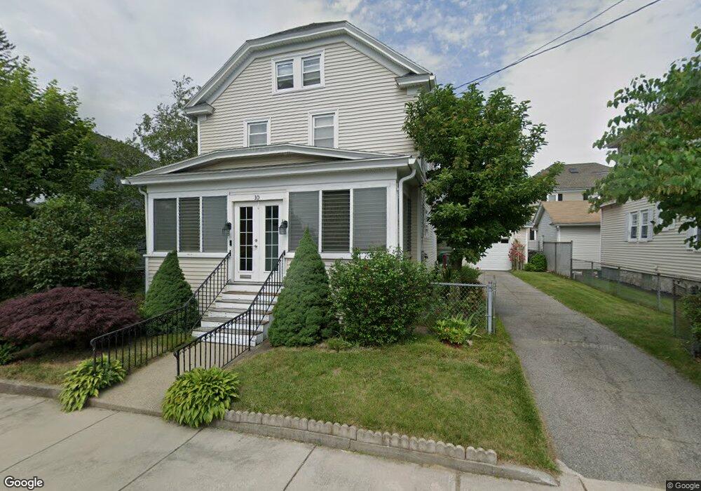
10 Staples St Lowell, MA 01851
Highlands NeighborhoodEstimated Value: $524,000 - $574,000
3
Beds
2
Baths
1,902
Sq Ft
$291/Sq Ft
Est. Value
About This Home
This home is located at 10 Staples St, Lowell, MA 01851 and is currently estimated at $553,525, approximately $291 per square foot. 10 Staples St is a home located in Middlesex County with nearby schools including Charles W. Morey Elementary School, Dr. Gertrude Bailey Elementary School, and Abraham Lincoln Elementary School.
Ownership History
Date
Name
Owned For
Owner Type
Purchase Details
Closed on
Jul 31, 1998
Sold by
Deroche Wilfred J and Deroche Alma
Bought by
Phavorabouth Monique P
Current Estimated Value
Home Financials for this Owner
Home Financials are based on the most recent Mortgage that was taken out on this home.
Original Mortgage
$117,000
Interest Rate
6.92%
Mortgage Type
Purchase Money Mortgage
Create a Home Valuation Report for This Property
The Home Valuation Report is an in-depth analysis detailing your home's value as well as a comparison with similar homes in the area
Home Values in the Area
Average Home Value in this Area
Purchase History
| Date | Buyer | Sale Price | Title Company |
|---|---|---|---|
| Phavorabouth Monique P | $130,000 | -- | |
| Phavorabouth Monique P | $130,000 | -- |
Source: Public Records
Mortgage History
| Date | Status | Borrower | Loan Amount |
|---|---|---|---|
| Open | Phavorabouth Monique P | $20,000 | |
| Open | Phavorabouth Monique P | $126,000 | |
| Closed | Phavorabouth Monique P | $117,000 |
Source: Public Records
Tax History
| Year | Tax Paid | Tax Assessment Tax Assessment Total Assessment is a certain percentage of the fair market value that is determined by local assessors to be the total taxable value of land and additions on the property. | Land | Improvement |
|---|---|---|---|---|
| 2025 | $5,490 | $478,200 | $164,900 | $313,300 |
| 2024 | $5,202 | $436,800 | $141,300 | $295,500 |
| 2023 | $4,906 | $395,000 | $122,900 | $272,100 |
| 2022 | $4,623 | $364,300 | $111,700 | $252,600 |
| 2021 | $4,315 | $320,600 | $97,100 | $223,500 |
| 2020 | $3,993 | $298,900 | $86,500 | $212,400 |
| 2019 | $3,874 | $275,900 | $86,700 | $189,200 |
| 2018 | $3,787 | $263,200 | $82,600 | $180,600 |
| 2017 | $3,630 | $243,300 | $75,000 | $168,300 |
| 2016 | $3,511 | $231,600 | $77,500 | $154,100 |
| 2015 | $3,410 | $220,300 | $74,800 | $145,500 |
| 2013 | $3,026 | $201,600 | $86,700 | $114,900 |
Source: Public Records
Map
Nearby Homes
- 118 Sanders Ave
- 142 Sanders Ave
- 234 Foster St
- 4 Tamarack St
- 173 Princeton Blvd
- 23 Burtt St
- 17 Edson St
- 45 Harvard St Unit 5 3rd fl
- 1311 Middlesex St
- 137 Pine St Unit 11
- 339 Pawtucket Blvd Unit 19
- 11 Warwick St Unit 3
- 295 Pawtucket Blvd Unit 7
- 37 Saint Paul St
- 312 Wilder St
- 49 Marginal St
- 351 Pawtucket Blvd Unit 3
- 351 Pawtucket Blvd Unit 29
- 311 Pawtucket Blvd Unit 3
- 307 Pawtucket Blvd Unit 24
Your Personal Tour Guide
Ask me questions while you tour the home.