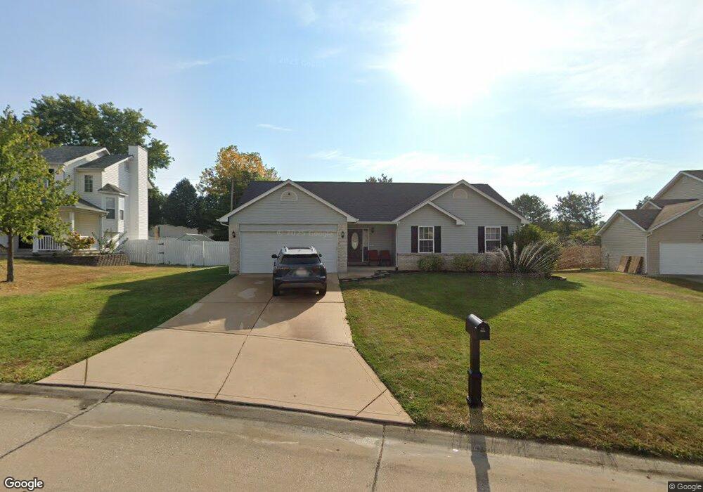
10 Tinsmith Ct O Fallon, MO 63366
Estimated Value: $327,980 - $370,000
3
Beds
2
Baths
1,441
Sq Ft
$239/Sq Ft
Est. Value
About This Home
This home is located at 10 Tinsmith Ct, O Fallon, MO 63366 and is currently estimated at $344,995, approximately $239 per square foot. 10 Tinsmith Ct is a home located in St. Charles County with nearby schools including Rock Creek Elementary School, Fort Zumwalt West Middle School, and Fort Zumwalt West High School.
Ownership History
Date
Name
Owned For
Owner Type
Purchase Details
Closed on
Jul 24, 2014
Sold by
Dell Brian O
Bought by
Walker Crystal C and Dell Crystal C O
Current Estimated Value
Purchase Details
Closed on
Jun 30, 1999
Sold by
Lucas James V and Lucas Pauline
Bought by
Odell Brian and Odell Crystal C
Home Financials for this Owner
Home Financials are based on the most recent Mortgage that was taken out on this home.
Original Mortgage
$118,646
Outstanding Balance
$32,316
Interest Rate
7.21%
Mortgage Type
FHA
Estimated Equity
$312,679
Create a Home Valuation Report for This Property
The Home Valuation Report is an in-depth analysis detailing your home's value as well as a comparison with similar homes in the area
Home Values in the Area
Average Home Value in this Area
Purchase History
| Date | Buyer | Sale Price | Title Company |
|---|---|---|---|
| Walker Crystal C | -- | None Available | |
| Odell Brian | $119,625 | Emmons Title Co |
Source: Public Records
Mortgage History
| Date | Status | Borrower | Loan Amount |
|---|---|---|---|
| Open | Odell Brian | $118,646 |
Source: Public Records
Tax History
| Year | Tax Paid | Tax Assessment Tax Assessment Total Assessment is a certain percentage of the fair market value that is determined by local assessors to be the total taxable value of land and additions on the property. | Land | Improvement |
|---|---|---|---|---|
| 2025 | $3,435 | $56,112 | -- | -- |
| 2023 | $3,437 | $51,854 | $0 | $0 |
| 2022 | $2,888 | $40,474 | $0 | $0 |
| 2021 | $2,890 | $40,474 | $0 | $0 |
| 2020 | $2,859 | $38,820 | $0 | $0 |
| 2019 | $2,866 | $38,820 | $0 | $0 |
| 2018 | $2,682 | $34,680 | $0 | $0 |
| 2017 | $2,645 | $34,680 | $0 | $0 |
| 2016 | $2,403 | $31,378 | $0 | $0 |
| 2015 | $2,234 | $31,378 | $0 | $0 |
| 2014 | $2,155 | $29,763 | $0 | $0 |
Source: Public Records
Map
Nearby Homes
- 3 Pinehurst Forest Ct
- 1234 Pinehurst Club Ct
- 14 Spangle Way Dr
- 8 Winter Forest Ct
- 159 Weatherby Landing Dr Unit 53
- 140 Weatherby Landing Dr
- 217 Roaring River Dr
- 20 Cherokee Sunset Ct Ct
- 962 Midpoint Dr
- 10 Southern Hills Ct
- 2325 Sundance Dr
- 11 Southern Hills Ct
- 109 Sterling Crossing Dr
- 1117 Turtle Creek Dr
- 151 N Wellington St
- 532 Bramblett Hills
- 604 Sunward Dr
- 5 Challenger Ct
- 76 Brook Hollow Ct
- 516 Sunward Dr
- 12 Tinsmith Ct
- 8 Tinsmith Ct
- 14 Tinsmith Ct
- 9 Tinsmith Ct
- 6 Tinsmith Ct
- 13 Tinsmith Ct
- 4 Tinsmith Ct
- 16 Tinsmith Ct
- 1350 Franklins Kite Dr
- 15 Tinsmith Ct
- 1344 Franklins Kite Dr
- 2 Tinsmith Ct
- 1338 Franklins Kite Dr
- 18 Tinsmith Ct
- 17 Tinsmith Ct
- 42 Quakers Place
- 1332 Franklins Kite Dr
- 702 Tinsmith Place
- 43 Quakers Place
- 20 Tinsmith Ct
Your Personal Tour Guide
Ask me questions while you tour the home.