M
Seller's Agent in 2025
Marnie Dubois
Keller Williams Realty
(207) 312-2125
1 in this area
146 Total Sales
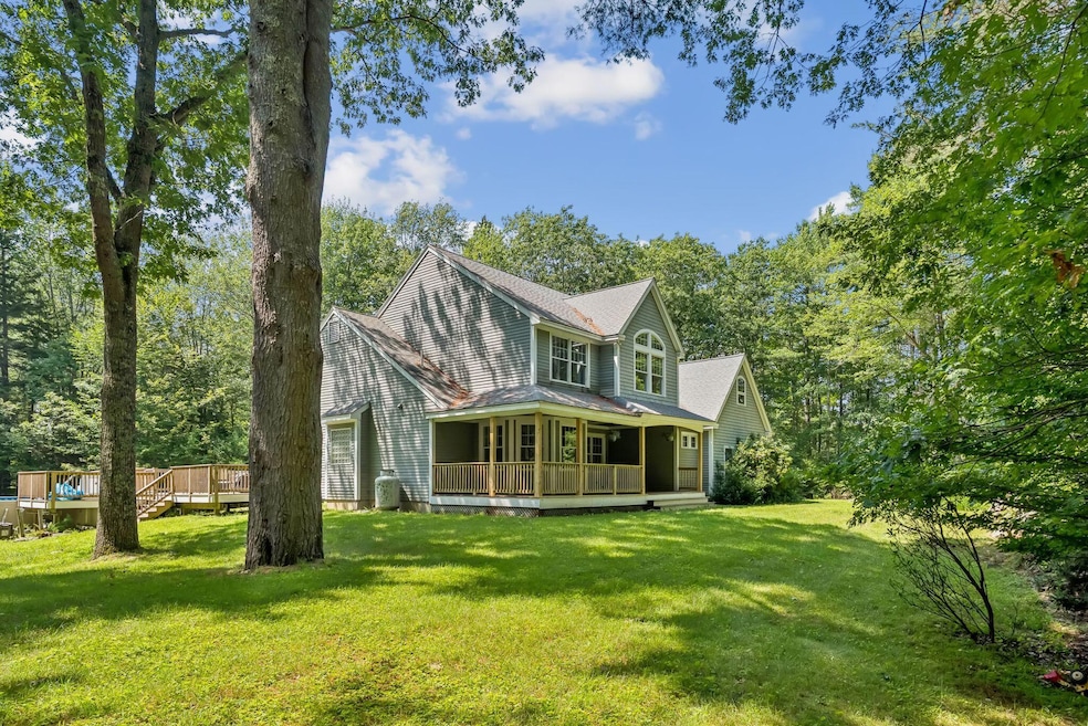


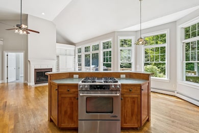
Modern Living Meets Natural Beauty - 4BR Contemporary on 5 Acres in Freeport
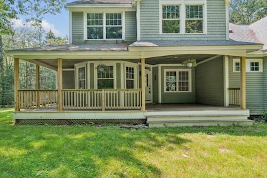
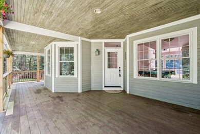
Discover your private retreat in the heart of Freeport. Set on 5 serene acres, this 4-bedroom, 2.5-bath contemporary blends modern design with the natural beauty of Maine.
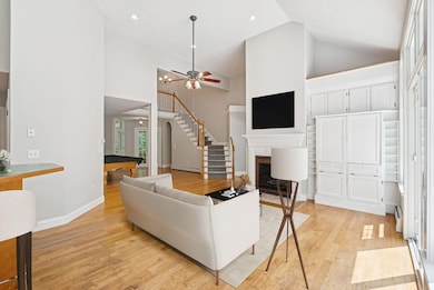
Inside, a grand entry welcomes you with soaring ceilings and abundant natural light. French doors open to a private office—perfect for remote work or quiet study. The stylish kitchen offers generous counter space and a walk-in pantry, flowing seamlessly into the inviting living area with its cozy fireplace. The first-floor primary suite provides a spa-like bath with a soaking tub, walk-in shower, and spacious walk-in closet. A convenient laundry room with utility sink completes the main level.
Upstairs, three large bedrooms and a versatile bonus room offer space for family, guests, or a home office.
Outside, enjoy wooded privacy, open yard space, and an expansive deck ideal for entertaining. A gated pool area with a crystal-clear above-ground pool enhances the lifestyle appeal.
All this, just minutes from the coast, downtown Freeport, shopping, dining, and I-295—offering peaceful seclusion without sacrificing convenience.
This rare offering combines modern living and natural beauty in one of Maine's most sought-after locations.
Last Buyer's Agent
Kenneth Greene
Classic Maine Realty, LLC
| Date | Type | Sale Price | Title Company |
|---|---|---|---|
| Warranty Deed | $750,000 | -- | |
| Warranty Deed | $750,000 | -- | |
| Warranty Deed | -- | -- | |
| Warranty Deed | -- | -- |
| Date | Status | Loan Amount | Loan Type |
|---|---|---|---|
| Previous Owner | $220,000 | Unknown |
| Date | Event | Price | List to Sale | Price per Sq Ft |
|---|---|---|---|---|
| 08/11/2025 08/11/25 | Sold | $750,000 | +3.5% | $286 / Sq Ft |
| 08/05/2025 08/05/25 | Pending | -- | -- | -- |
| 07/30/2025 07/30/25 | For Sale | $724,900 | -- | $276 / Sq Ft |
| Year | Tax Paid | Tax Assessment Tax Assessment Total Assessment is a certain percentage of the fair market value that is determined by local assessors to be the total taxable value of land and additions on the property. | Land | Improvement |
|---|---|---|---|---|
| 2025 | $9,631 | $695,400 | $194,500 | $500,900 |
| 2024 | $9,117 | $682,900 | $185,200 | $497,700 |
| 2023 | $8,249 | $599,900 | $168,300 | $431,600 |
| 2022 | $8,071 | $591,300 | $159,700 | $431,600 |
| 2021 | $7,894 | $591,300 | $159,700 | $431,600 |
| 2020 | $7,700 | $550,000 | $148,100 | $401,900 |
| 2019 | $7,402 | $517,600 | $139,700 | $377,900 |
| 2018 | $7,239 | $481,000 | $131,200 | $349,800 |
| 2017 | $6,905 | $461,900 | $128,200 | $333,700 |
| 2016 | $6,728 | $425,800 | $116,200 | $309,600 |
| 2015 | $6,712 | $399,500 | $106,000 | $293,500 |
| 2014 | $6,312 | $399,500 | $106,000 | $293,500 |
| 2013 | $6,158 | $388,500 | $102,200 | $286,300 |
M
Seller's Agent in 2025
Marnie Dubois
Keller Williams Realty
(207) 312-2125
1 in this area
146 Total Sales
K
Buyer's Agent in 2025
Kenneth Greene
Classic Maine Realty, LLC

Buyer's Agent in 2025
Kenny Greene
Harborview Properties, Inc.
(207) 653-0773
2 in this area
67 Total Sales
Source: Maine Listings
MLS Number: 1632420
APN: FPRT-000018-000062-000020
Disclaimer: Certain information contained herein is derived from information provided by parties other than Homes.com. All information provided is deemed reliable, but is not guaranteed to be accurate and should be independently verified.
![]() Listing data is derived in whole or in part from Maine Real Estate Information System, Inc. (d/b/a Maine Listings) and is for consumers' personal, noncommercial use only. Dimensions are approximate and not guaranteed. All data should be independently verified.
Listing data is derived in whole or in part from Maine Real Estate Information System, Inc. (d/b/a Maine Listings) and is for consumers' personal, noncommercial use only. Dimensions are approximate and not guaranteed. All data should be independently verified.
© 2026 Maine Real Estate Information System, Inc. All Rights Reserved. Equal Housing Opportunity.
Homes.com, LLC, 17600 Laguna Canyon Rd Irvine, CA 92618 (888)-952-6393
![]()
Ask me questions while you tour the home.