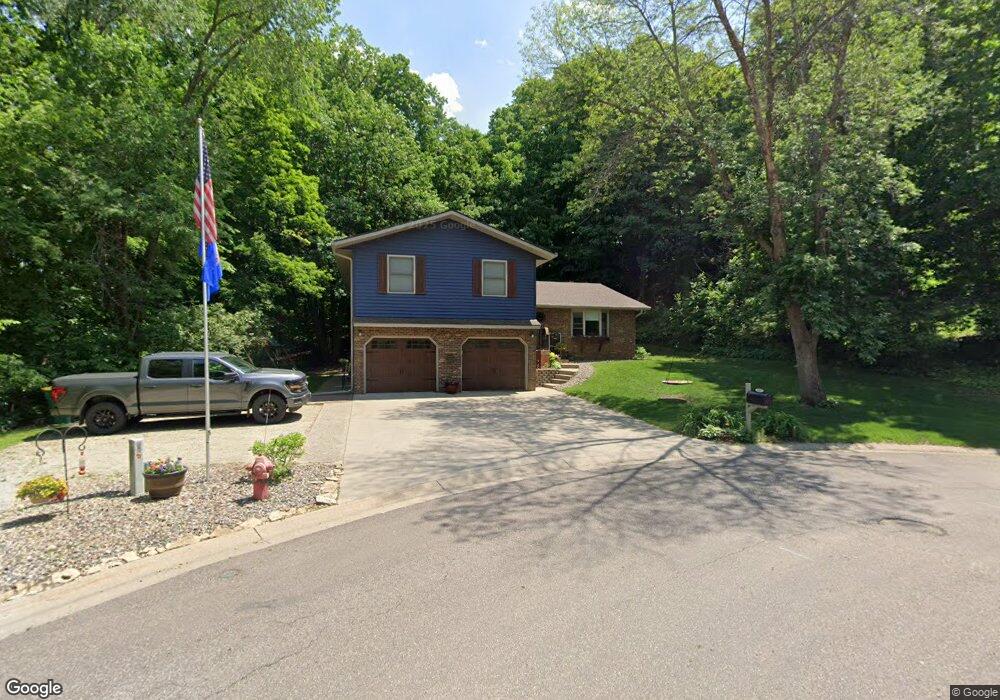
100 Grove St N Cannon Falls, MN 55009
Estimated Value: $379,000 - $442,000
3
Beds
2
Baths
1,944
Sq Ft
$214/Sq Ft
Est. Value
About This Home
This home is located at 100 Grove St N, Cannon Falls, MN 55009 and is currently estimated at $415,758, approximately $213 per square foot. 100 Grove St N is a home located in Goodhue County with nearby schools including Cannon Falls Elementary School, Cannon Falls High School and Middle School, and St. Paul's Lutheran Elementary School.
Ownership History
Date
Name
Owned For
Owner Type
Purchase Details
Closed on
Mar 28, 2003
Sold by
Nobach Anthony A and Nobach Judy A
Bought by
Godfrey David H and Godfrey Alison L
Current Estimated Value
Purchase Details
Closed on
Jun 19, 1998
Sold by
Mcguire Richard F and Mcguire Nancy A
Bought by
Nobach Anthony A and Nobach Judy A
Create a Home Valuation Report for This Property
The Home Valuation Report is an in-depth analysis detailing your home's value as well as a comparison with similar homes in the area
Home Values in the Area
Average Home Value in this Area
Purchase History
| Date | Buyer | Sale Price | Title Company |
|---|---|---|---|
| Godfrey David H | $215,000 | -- | |
| Nobach Anthony A | $175,000 | -- |
Source: Public Records
Tax History Compared to Growth
Tax History
| Year | Tax Paid | Tax Assessment Tax Assessment Total Assessment is a certain percentage of the fair market value that is determined by local assessors to be the total taxable value of land and additions on the property. | Land | Improvement |
|---|---|---|---|---|
| 2025 | $5,358 | $418,600 | $85,300 | $333,300 |
| 2024 | $5,358 | $418,600 | $85,000 | $333,600 |
| 2023 | $2,675 | $405,000 | $85,000 | $320,000 |
| 2022 | $4,728 | $374,200 | $73,500 | $300,700 |
| 2021 | $4,682 | $319,400 | $73,500 | $245,900 |
| 2020 | $4,496 | $310,500 | $73,500 | $237,000 |
| 2019 | $4,250 | $292,100 | $73,500 | $218,600 |
| 2018 | $3,784 | $275,700 | $54,500 | $221,200 |
| 2017 | $3,562 | $261,900 | $54,500 | $207,400 |
| 2016 | $3,348 | $245,000 | $54,500 | $190,500 |
| 2015 | $2,960 | $231,700 | $54,500 | $177,200 |
| 2014 | -- | $203,400 | $54,500 | $148,900 |
Source: Public Records
Map
Nearby Homes
- Virginia Plan at Hardwood Estates - Single Family Lots
- Vermont Plan at Hardwood Estates - Single Family Lots
- Sycamore Plan at Hardwood Estates - Single Family Lots
- Tennessee Plan at Hardwood Estates - Single Family Lots
- Summerlyn Plan at Hardwood Estates - Single Family Lots
- St. James Plan at Hardwood Estates - Single Family Lots
- Rhode Island Plan at Hardwood Estates - Single Family Lots
- St. Charles Plan at Hardwood Estates - Single Family Lots
- Spruce Plan at Hardwood Estates - Single Family Lots
- Oakwood II Plan at Hardwood Estates - Single Family Lots
- Poplar Plan at Hardwood Estates - Single Family Lots
- Oakwood Plan at Hardwood Estates - Single Family Lots
- Madison Plan at Hardwood Estates - Single Family Lots
- Magnolia Plan at Hardwood Estates - Single Family Lots
- Illinois Plan at Hardwood Estates - Single Family Lots
- Cannonball Plan at Hardwood Estates - Single Family Lots
- Bismarck Plan at Hardwood Estates - Single Family Lots
- Boardwalk Plan at Hardwood Estates - Single Family Lots
- Balsam II Plan at Hardwood Estates - Single Family Lots
- Aberdeen Plan at Hardwood Estates - Single Family Lots
- 30410 72nd Ave Way Unit 37998023
- xxx xxx 72nd Avenue Way
- xxx 72nd Avenue Way
- xxxxxx 72nd Avenue Way
- xxxx 72nd Avenue Way
- 30370 72nd Avenue Way
- 30360 72nd Avenue Way
- 30350 72nd Avenue Way
- 0 Xxxx Highway 19 Unit 6095621
- 30340 72nd Avenue Way
- xx xx 72nd Avenue Way
- 30400 71st Avenue Way
- 30330 72nd Avenue Way
- 30330 72nd Ave Way
- xxxx Hwy 19
- 30320 72nd Avenue Way
- 30319 72nd Avenue Way
- 7150 Highway 19 Blvd
- 7124 Highway 19 Blvd
- 7124 Highway 19 Blvd