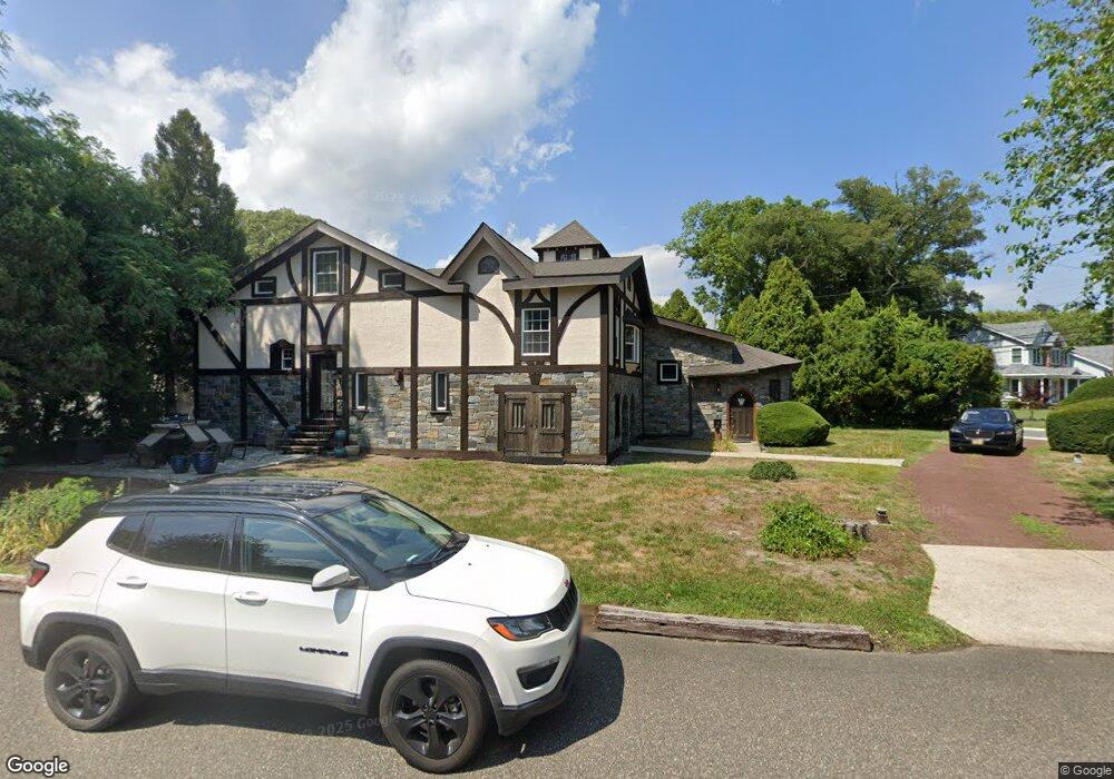
100 Van Sant Ave Linwood, NJ 08221
Estimated Value: $539,000 - $898,000
--
Bed
--
Bath
3,384
Sq Ft
$214/Sq Ft
Est. Value
About This Home
This home is located at 100 Van Sant Ave, Linwood, NJ 08221 and is currently estimated at $723,723, approximately $213 per square foot. 100 Van Sant Ave is a home located in Atlantic County with nearby schools including Seaview Elementary School, Belhaven Middle School, and Mainland Regional High School.
Ownership History
Date
Name
Owned For
Owner Type
Purchase Details
Closed on
May 19, 2005
Sold by
Mitchell Lawrence A
Bought by
White Keith A
Current Estimated Value
Purchase Details
Closed on
Jan 13, 2004
Sold by
Mitchell Sharon A
Bought by
Mitchell Lawrence A
Purchase Details
Closed on
May 28, 1999
Sold by
Mitchell Lawrence A
Bought by
Mitchell Sharon A
Purchase Details
Closed on
Nov 1, 1998
Sold by
Mitchell Estelle
Bought by
Mitchell Lawrence A
Purchase Details
Closed on
Dec 30, 1997
Sold by
Environmental Design Ltd
Bought by
Mitchell Estelle
Create a Home Valuation Report for This Property
The Home Valuation Report is an in-depth analysis detailing your home's value as well as a comparison with similar homes in the area
Home Values in the Area
Average Home Value in this Area
Purchase History
| Date | Buyer | Sale Price | Title Company |
|---|---|---|---|
| White Keith A | $340,000 | -- | |
| Mitchell Lawrence A | $92,010 | -- | |
| Mitchell Sharon A | $92,000 | -- | |
| Mitchell Lawrence A | $91,857 | Landis Title Corporation | |
| Mitchell Estelle | -- | -- |
Source: Public Records
Tax History Compared to Growth
Tax History
| Year | Tax Paid | Tax Assessment Tax Assessment Total Assessment is a certain percentage of the fair market value that is determined by local assessors to be the total taxable value of land and additions on the property. | Land | Improvement |
|---|---|---|---|---|
| 2025 | $15,443 | $404,800 | $104,800 | $300,000 |
| 2024 | $15,443 | $404,800 | $104,800 | $300,000 |
| 2023 | $14,727 | $404,800 | $104,800 | $300,000 |
| 2022 | $14,727 | $404,800 | $104,800 | $300,000 |
| 2021 | $12,235 | $339,300 | $104,800 | $234,500 |
| 2020 | $12,066 | $339,300 | $104,800 | $234,500 |
| 2019 | $11,808 | $339,300 | $104,800 | $234,500 |
| 2018 | $11,543 | $339,300 | $104,800 | $234,500 |
| 2017 | $11,312 | $339,300 | $104,800 | $234,500 |
| 2016 | $10,932 | $339,300 | $104,800 | $234,500 |
| 2015 | $10,942 | $339,300 | $104,800 | $234,500 |
| 2014 | $10,518 | $339,300 | $104,800 | $234,500 |
Source: Public Records
Map
Nearby Homes
- 110 W Poplar Ave
- 104 W Poplar Ave
- 105 W Edgewood Ave
- 1050 Shore Rd
- 130 Wilson Ave
- 901 Oak Ave
- 605 Shore Rd
- 1201 Woodlynne Blvd
- 210 Haines Ave
- 309 Haines Ave
- 1011 New Rd
- 1016 Richard Dr
- 500 Davis Ave
- 7 Woodstock Dr
- 911 Bartlett Ave
- 1005 Bartlett Ave
- 301 Wabash Ave
- 1026 Bartlett Dr
- 1026 Bartlett Ave
- 1917 Ventnor Ave