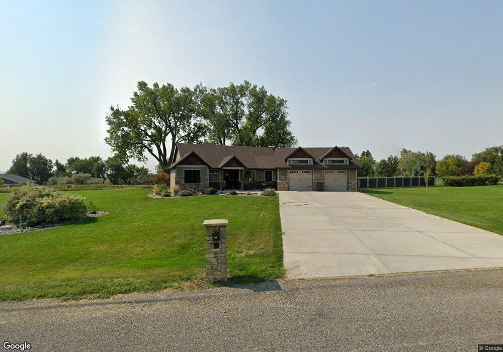
1000 Longview Rd Laurel, MT 59044
Estimated Value: $792,000 - $876,605
4
Beds
3
Baths
3,486
Sq Ft
$240/Sq Ft
Est. Value
About This Home
This home is located at 1000 Longview Rd, Laurel, MT 59044 and is currently estimated at $836,151, approximately $239 per square foot. 1000 Longview Rd is a home located in Yellowstone County with nearby schools including Fred W. Graff School, West School, and Laurel Middle School.
Ownership History
Date
Name
Owned For
Owner Type
Purchase Details
Closed on
Sep 13, 2024
Sold by
Steven J And Laurie S Anderson Trust and Anderson Steven J
Bought by
Hansen Todd C and Hansen Maggie Raaen
Current Estimated Value
Home Financials for this Owner
Home Financials are based on the most recent Mortgage that was taken out on this home.
Original Mortgage
$778,500
Interest Rate
6.73%
Mortgage Type
Construction
Purchase Details
Closed on
May 21, 2020
Sold by
Anderson Steven J and Anderson Laurie S
Bought by
Anderson Steven J and Anderson Laurie S
Purchase Details
Closed on
May 20, 2010
Sold by
Anderson Steven J and Anderson Laurie S
Bought by
Kenmark Corporation
Purchase Details
Closed on
May 3, 2010
Sold by
Foss Clarence A and Foos Naomi
Bought by
Anderson Steven J and Anderson Laurie S
Create a Home Valuation Report for This Property
The Home Valuation Report is an in-depth analysis detailing your home's value as well as a comparison with similar homes in the area
Home Values in the Area
Average Home Value in this Area
Purchase History
| Date | Buyer | Sale Price | Title Company |
|---|---|---|---|
| Hansen Todd C | -- | First Montana Title | |
| Anderson Steven J | -- | None Available | |
| Kenmark Corporation | -- | None Available | |
| Anderson Steven J | -- | None Available |
Source: Public Records
Mortgage History
| Date | Status | Borrower | Loan Amount |
|---|---|---|---|
| Closed | Hansen Todd C | $778,500 |
Source: Public Records
Tax History
| Year | Tax Paid | Tax Assessment Tax Assessment Total Assessment is a certain percentage of the fair market value that is determined by local assessors to be the total taxable value of land and additions on the property. | Land | Improvement |
|---|---|---|---|---|
| 2025 | $4,061 | $741,300 | $117,855 | $623,445 |
| 2024 | $4,061 | $585,300 | $86,617 | $498,683 |
| 2023 | $4,060 | $585,300 | $86,617 | $498,683 |
| 2022 | $3,111 | $481,900 | $0 | $0 |
| 2021 | $3,424 | $481,900 | $0 | $0 |
| 2020 | $3,516 | $478,400 | $0 | $0 |
| 2019 | $3,387 | $478,400 | $0 | $0 |
| 2018 | $3,786 | $464,800 | $0 | $0 |
| 2017 | $3,437 | $464,800 | $0 | $0 |
| 2016 | $3,254 | $445,200 | $0 | $0 |
| 2015 | $3,206 | $451,000 | $0 | $0 |
| 2014 | $2,461 | $185,871 | $0 | $0 |
Source: Public Records
Map
Nearby Homes
- 1031 Fir Ave
- 1104 E 8th St
- 1108 E 8th St
- 1319 Valley Dr
- 605 Date Ave
- 717 E 5th, 506 Alder Ave
- 717 E 5th St
- 601 E 5th St
- 516 Pennsylvania Ave
- 1631 Valley Dr
- 801 E 4th St
- 414 Wyoming Ave
- 110 E 5th St
- 1665 Wild Lupine Ln
- 1216 W 12th Street Cir
- 1254 W Beartooth Dr
- 603 5th Ave
- 1109 10th Ave
- 1735 Lobo Dr
- 1013 W 12th St
- 950 Longview Rd
- 000 Longview Rd
- 0 Longview Rd
- 900 Longview Rd
- 1115 Longview Rd
- 1030 Longview Rd
- 1119 Longview Rd
- 0 Green Bluff Ave
- 1301 Alder Ave
- 1000 Rockfork Cir
- 895 Longview Rd
- 1405 Green Bluff Ave
- 1370 Hill Crest Ave
- 850 Longview Rd
- 980 Rockfork Cir
- 1310 Hill Crest Ave
- 1415 Alder Ave
- 0 Rockfork Cir
- 1020 Rockfork Cir
- 975 Rockfork Cir
Your Personal Tour Guide
Ask me questions while you tour the home.