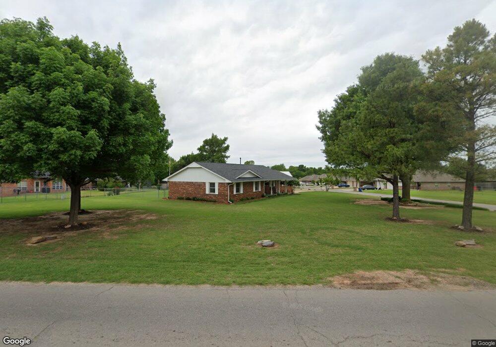
1000 S Shepard Ave El Reno, OK 73036
Estimated Value: $173,101 - $212,000
3
Beds
2
Baths
1,563
Sq Ft
$123/Sq Ft
Est. Value
About This Home
This home is located at 1000 S Shepard Ave, El Reno, OK 73036 and is currently estimated at $192,775, approximately $123 per square foot. 1000 S Shepard Ave is a home located in Canadian County with nearby schools including Hillcrest Elementary School, Rose Witcher Elementary School, and Lincoln Learning Center.
Ownership History
Date
Name
Owned For
Owner Type
Purchase Details
Closed on
Jul 10, 2019
Sold by
Larry S Meats Inc
Bought by
State Of Oklahoma
Current Estimated Value
Purchase Details
Closed on
Jun 18, 2019
Sold by
Brown Linda Gaye
Bought by
State Of Oklahoma
Purchase Details
Closed on
Apr 10, 2019
Sold by
Feddersen Marcus Dale
Bought by
State Of Oklahoma
Purchase Details
Closed on
Dec 10, 1999
Sold by
Standerfer Bill B and Standerfer Pamela G
Bought by
Hulsey Billy L and Hulsey Retta A
Purchase Details
Closed on
Jul 18, 1997
Sold by
Mitchell Gary L and Mitchell Carla
Create a Home Valuation Report for This Property
The Home Valuation Report is an in-depth analysis detailing your home's value as well as a comparison with similar homes in the area
Home Values in the Area
Average Home Value in this Area
Purchase History
| Date | Buyer | Sale Price | Title Company |
|---|---|---|---|
| State Of Oklahoma | -- | None Available | |
| State Of Oklahoma | -- | None Available | |
| State Of Oklahoma | -- | None Available | |
| Hulsey Billy L | $89,000 | -- | |
| -- | $79,000 | -- |
Source: Public Records
Tax History Compared to Growth
Tax History
| Year | Tax Paid | Tax Assessment Tax Assessment Total Assessment is a certain percentage of the fair market value that is determined by local assessors to be the total taxable value of land and additions on the property. | Land | Improvement |
|---|---|---|---|---|
| 2024 | $1,640 | $16,796 | $1,337 | $15,459 |
| 2023 | $1,640 | $16,307 | $1,337 | $14,970 |
| 2022 | $1,596 | $15,832 | $1,337 | $14,495 |
| 2021 | $1,583 | $15,371 | $1,337 | $14,034 |
| 2020 | $1,515 | $14,923 | $1,337 | $13,586 |
| 2019 | $1,533 | $14,489 | $1,337 | $13,152 |
| 2018 | $1,470 | $14,067 | $1,337 | $12,730 |
| 2017 | $1,452 | $13,657 | $1,337 | $12,320 |
| 2016 | $1,279 | $12,433 | $1,337 | $11,096 |
| 2015 | $1,180 | $11,719 | $1,337 | $10,382 |
| 2014 | $1,180 | $11,378 | $1,337 | $10,041 |
Source: Public Records
Map
Nearby Homes
- 1101 Gabriel St
- 1621 Chuck Wagon Dr
- 1608 Chuck Wagon Dr
- 1607 Chuck Wagon Dr
- 1219 Heritage Dr
- 1207 Heritage Dr
- 1117 SW Heritage Dr
- 313 Hal Dr
- 811 S Hoff Ave
- 1008 E Woodson St
- 100 N Donald Ave
- 900 E Woodson St
- 819 S Macomb Ave
- 120 N Donald Ave
- 101 N El Reno Ave
- 603 E Wade St
- 811 S Barker Ave
- 600 S Macomb Ave
- 516 S Macomb Ave
- 221 N L Ave
- 1848 Jack Rabbit Ln
- 1821 Jack Rabbit Ln
- 1837 Jack Rabbit Ln
- 1828 Jack Rabbit Ln
- 1813 Jack Rabbit Ln
- 1804 Jack Rabbit Ln
- 1816 Jack Rabbit Ln
- 1844 Jack Rabbit Ln
- 1856 Jack Rabbit Ln
- 1829 Jack Rabbit Ln
- 1640 Eighty-Niner Terrace
- 1762 Eighty-Niner Terrace
- 1746 Eighty-Niner Terrace
- 1836 Jack Rabbit Ln
- 1632 Eighty Niner Terrace
- 1808 Jack Rabbit Ln
- 1832 Jack Rabbit Ln
- 1833 Jack Rabbit Ln
- 1860 Jack Rabbit Ln
- 1616 Eighty-Niner Terrace