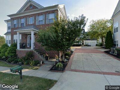
10003 Orland Stone Dr Bristow, VA 20136
Braemar NeighborhoodEstimated Value: $675,413 - $701,000
4
Beds
4
Baths
2,507
Sq Ft
$275/Sq Ft
Est. Value
About This Home
This home is located at 10003 Orland Stone Dr, Bristow, VA 20136 and is currently estimated at $688,853, approximately $274 per square foot. 10003 Orland Stone Dr is a home located in Prince William County with nearby schools including Patriot High School, T. Clay Wood Elementary School, and E.H. Marsteller Middle School.
Ownership History
Date
Name
Owned For
Owner Type
Purchase Details
Closed on
Dec 30, 2004
Sold by
Brookfield Braemar Llc
Bought by
Solis Freddy E
Current Estimated Value
Home Financials for this Owner
Home Financials are based on the most recent Mortgage that was taken out on this home.
Original Mortgage
$390,550
Interest Rate
5.73%
Mortgage Type
New Conventional
Create a Home Valuation Report for This Property
The Home Valuation Report is an in-depth analysis detailing your home's value as well as a comparison with similar homes in the area
Home Values in the Area
Average Home Value in this Area
Purchase History
| Date | Buyer | Sale Price | Title Company |
|---|---|---|---|
| Solis Freddy E | $488,190 | -- |
Source: Public Records
Mortgage History
| Date | Status | Borrower | Loan Amount |
|---|---|---|---|
| Open | Solis Freddy Eduardo | $376,500 | |
| Closed | Solis Freedy | $36,050 | |
| Closed | Solis Freddy E | $390,550 |
Source: Public Records
Tax History Compared to Growth
Tax History
| Year | Tax Paid | Tax Assessment Tax Assessment Total Assessment is a certain percentage of the fair market value that is determined by local assessors to be the total taxable value of land and additions on the property. | Land | Improvement |
|---|---|---|---|---|
| 2024 | $5,876 | $590,800 | $163,000 | $427,800 |
| 2023 | $5,850 | $562,200 | $150,000 | $412,200 |
| 2022 | $5,860 | $518,800 | $122,500 | $396,300 |
| 2021 | $5,733 | $469,600 | $112,000 | $357,600 |
| 2020 | $6,541 | $422,000 | $101,400 | $320,600 |
| 2019 | $6,479 | $418,000 | $101,400 | $316,600 |
| 2018 | $4,741 | $392,600 | $96,600 | $296,000 |
| 2017 | $4,672 | $378,100 | $96,600 | $281,500 |
| 2016 | $4,413 | $360,100 | $91,500 | $268,600 |
| 2015 | $4,224 | $358,000 | $91,500 | $266,500 |
| 2014 | $4,224 | $337,000 | $87,400 | $249,600 |
Source: Public Records
Map
Nearby Homes
- 10079 Orland Stone Dr
- 12814 Arnot Ln
- 9901 Airedale Ct
- 12000 Rutherglen Place
- 12937 Correen Hills Dr
- 12920 Fetlar Way
- 13049 Ormond Dr
- 9565 Fintry St
- 9573 Loma Dr
- 12905 Ness Hollow Ct
- 10154 Broadsword Dr
- 9278 Glen Meadow Ln
- 12435 Iona Sound Dr
- 12573 Garry Glen Dr
- 12931 Brigstock Ct
- 12561 Garry Glen Dr
- 12630 Garry Glen Dr
- 9533 Ballagan Ct
- 12694 Arthur Graves jr Ct
- 10020 Moxleys Ford Ln
- 10003 Orland Stone Dr
- 10005 Orland Stone Dr
- 10001 Orland Stone Dr
- 10138 Orland Stone Dr
- 10140 Orland Stone Dr
- 10007 Orland Stone Dr
- 10009 Orland Stone Dr
- 10142 Orland Stone Dr
- 10015 Orland Stone Dr
- 10136 Orland Stone Dr
- 10013 Orland Stone Dr
- 10144 Orland Stone Dr
- 10011 Pentland Hills Way
- 10013 Pentland Hills Way
- 10017 Orland Stone Dr
- 10015 Pentland Hills Way
- 10019 Orland Stone Dr
- 10021 Orland Stone Dr
- 10009 Pentland Hills Way
- 10135 Orland Stone Dr