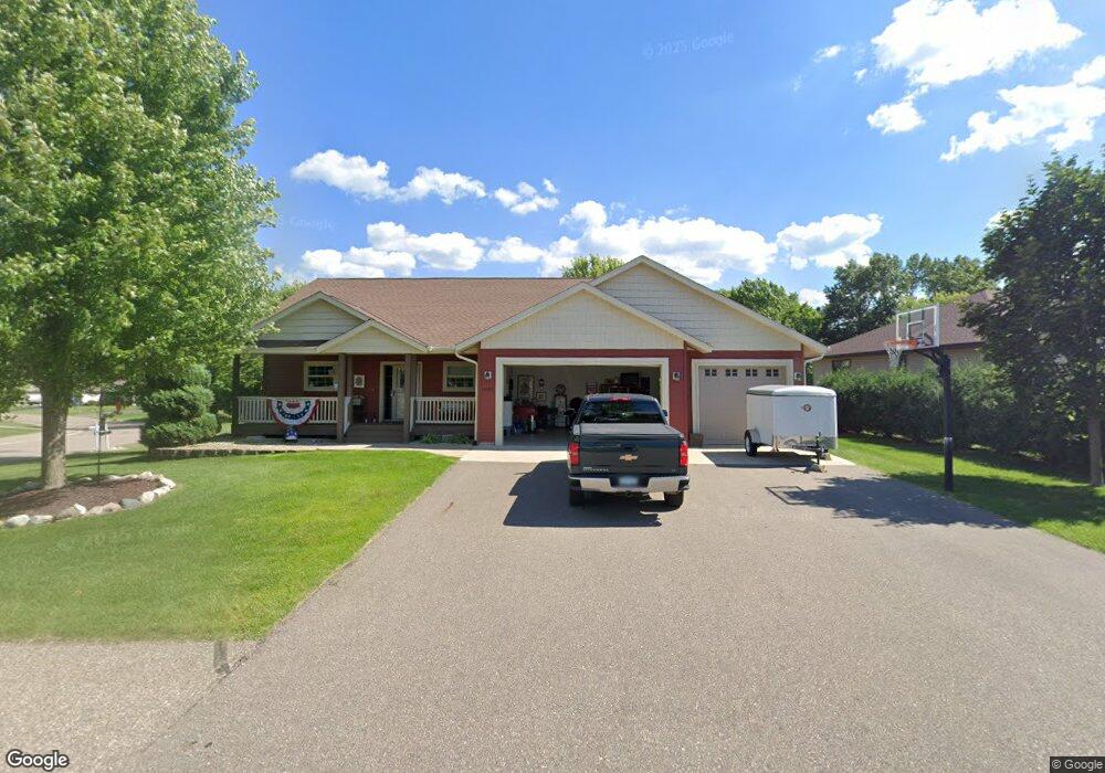
1001 Bay Cir S Annandale, MN 55302
Estimated Value: $428,000 - $482,000
3
Beds
3
Baths
1,460
Sq Ft
$311/Sq Ft
Est. Value
About This Home
This home is located at 1001 Bay Cir S, Annandale, MN 55302 and is currently estimated at $453,656, approximately $310 per square foot. 1001 Bay Cir S is a home located in Wright County with nearby schools including Annandale Elementary School, Annandale Middle School, and Annandale Senior High School.
Ownership History
Date
Name
Owned For
Owner Type
Purchase Details
Closed on
Apr 17, 2020
Sold by
Daniels Andrew and Daniels Catherine
Bought by
Jung Gary F and Jung Constance M
Current Estimated Value
Purchase Details
Closed on
Aug 2, 2019
Sold by
Linder Chad B and Linder Rebecca L
Bought by
Daniels Andrew and Daniels Catherine
Purchase Details
Closed on
Apr 28, 2005
Sold by
Emmerich Development Corp
Bought by
Linder Chad B and Baker Becky L
Create a Home Valuation Report for This Property
The Home Valuation Report is an in-depth analysis detailing your home's value as well as a comparison with similar homes in the area
Home Values in the Area
Average Home Value in this Area
Purchase History
| Date | Buyer | Sale Price | Title Company |
|---|---|---|---|
| Jung Gary F | $360,000 | Northland Title | |
| Daniels Andrew | $60,000 | Northland Title | |
| Linder Chad B | $47,900 | -- |
Source: Public Records
Tax History Compared to Growth
Tax History
| Year | Tax Paid | Tax Assessment Tax Assessment Total Assessment is a certain percentage of the fair market value that is determined by local assessors to be the total taxable value of land and additions on the property. | Land | Improvement |
|---|---|---|---|---|
| 2025 | $4,366 | $454,700 | $68,000 | $386,700 |
| 2024 | $4,308 | $433,500 | $65,000 | $368,500 |
| 2023 | $4,330 | $426,800 | $55,000 | $371,800 |
| 2022 | $4,302 | $384,700 | $58,000 | $326,700 |
| 2021 | $3,282 | $334,700 | $50,000 | $284,700 |
| 2020 | $3,404 | $254,700 | $50,000 | $204,700 |
| 2019 | $3,254 | $255,800 | $0 | $0 |
| 2018 | $3,066 | $227,400 | $0 | $0 |
| 2017 | $3,006 | $215,500 | $0 | $0 |
| 2016 | $2,978 | $0 | $0 | $0 |
| 2015 | $2,878 | $0 | $0 | $0 |
| 2014 | -- | $0 | $0 | $0 |
Source: Public Records
Map
Nearby Homes
- 970 Acacia Dr S
- 945 Acacia Cir S
- 750 Morrison Ave S
- 800 Morrison Ave NW
- 810 Morrison Ave NW
- 7425 Nevens Ave NW
- 520 Douglas Dr S
- 510 Douglas Dr S
- 681 Irwin Cir
- 7541 Lake John Dr
- 511 Douglas Dr S
- 7581 Lake John Dr
- Olson Plan at Triplett Farms
- Lincoln Plan at Triplett Farms
- Goodhue Plan at Triplett Farms
- Henderson Plan at Triplett Farms
- Hancock Plan at Triplett Farms
- Floyd Plan at Triplett Farms
- Madden Plan at Triplett Farms
- Rachel Plan at Triplett Farms
- 1005 Bay Cir S
- Lot 2 Bay Cir
- 1011 Bay Cir S
- 1000 Acacia Dr
- 1000 Acacia Dr S
- 1002 Bay Cir
- 1010 Acacia Dr
- 1004 Bay Cir
- 990 Acacia Dr S
- 1017 Bay Cir S
- 1006 Bay Cir S
- 1020 Acacia Dr
- 0 Lot 2 Bay Circle-- Unit 4369912
- 1003 Beech Ln S
- 1021 Bay Cir S
- 1008 Bay Cir
- 1007 Beech Ln S
- 1007 Beech Ln
- 995 Acacia Dr S
- 1030 Acacia Dr S