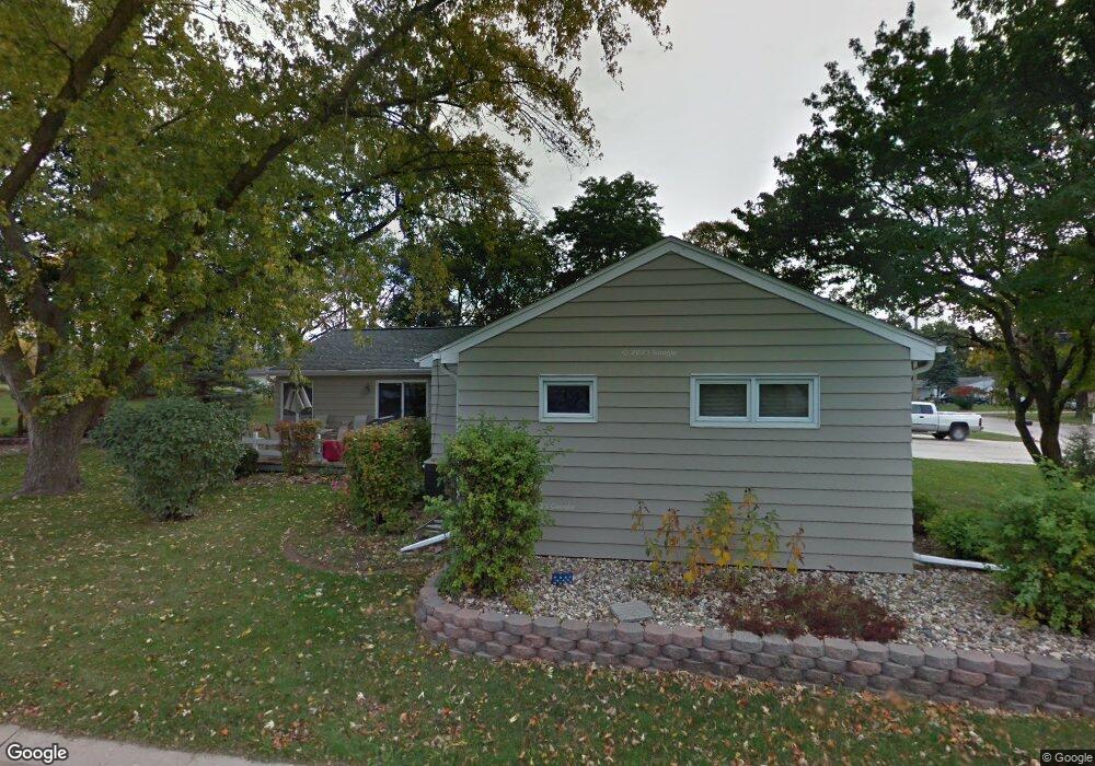
1002 12th St NE Mason City, IA 50401
Estimated Value: $191,385 - $277,000
3
Beds
2
Baths
1,914
Sq Ft
$117/Sq Ft
Est. Value
About This Home
This home is located at 1002 12th St NE, Mason City, IA 50401 and is currently estimated at $223,596, approximately $116 per square foot. 1002 12th St NE is a home located in Cerro Gordo County with nearby schools including Mason City High School, Mason City Seventh Day Adventi, and North Iowa Christian School.
Ownership History
Date
Name
Owned For
Owner Type
Purchase Details
Closed on
Oct 17, 2005
Sold by
Deshler Jennifer J
Bought by
Muntz Rita R
Current Estimated Value
Home Financials for this Owner
Home Financials are based on the most recent Mortgage that was taken out on this home.
Original Mortgage
$85,000
Interest Rate
5.8%
Mortgage Type
New Conventional
Create a Home Valuation Report for This Property
The Home Valuation Report is an in-depth analysis detailing your home's value as well as a comparison with similar homes in the area
Home Values in the Area
Average Home Value in this Area
Purchase History
| Date | Buyer | Sale Price | Title Company |
|---|---|---|---|
| Muntz Rita R | $136,750 | -- | |
| Muniz Rita R | $135,750 | None Available |
Source: Public Records
Mortgage History
| Date | Status | Borrower | Loan Amount |
|---|---|---|---|
| Closed | Muniz Rita R | $85,000 |
Source: Public Records
Tax History Compared to Growth
Tax History
| Year | Tax Paid | Tax Assessment Tax Assessment Total Assessment is a certain percentage of the fair market value that is determined by local assessors to be the total taxable value of land and additions on the property. | Land | Improvement |
|---|---|---|---|---|
| 2024 | $2,222 | $162,680 | $24,720 | $137,960 |
| 2023 | $2,572 | $162,680 | $24,720 | $137,960 |
| 2022 | $2,624 | $138,860 | $19,020 | $119,840 |
| 2021 | $2,550 | $136,470 | $19,020 | $117,450 |
| 2020 | $2,736 | $126,200 | $19,020 | $107,180 |
| 2019 | $2,318 | $0 | $0 | $0 |
| 2018 | $2,414 | $0 | $0 | $0 |
| 2017 | $2,476 | $0 | $0 | $0 |
| 2016 | $2,410 | $0 | $0 | $0 |
| 2015 | $2,410 | $0 | $0 | $0 |
| 2014 | $2,338 | $0 | $0 | $0 |
| 2013 | $2,246 | $0 | $0 | $0 |
Source: Public Records
Map
Nearby Homes
- 1006 12th St NE
- 1021 12th St NE
- 938 12th St NE
- 1416 N Kentucky Ave
- 1419 N Kentucky Ave
- 1100 N Tennessee Place
- 1306 N Rhode Island Ave
- 1368 12th St NE
- 110 N Kentucky Ave
- 807 10th St NE
- 726 11th St NE
- 1551 N Rhode Island Ave
- 716 15th St NE
- 1008 N Hampshire Ave
- 705 15th Place NE
- 1533 Plymouth Rd
- 1538 N Hampshire Ave
- 729 17th St NE
- 5 Highland Park Ct
- 22 Asbury Place Unit Boulder Road
- 1255 N Kentucky Ave Unit Lot 16
- 956 12th St NE
- 1252 N Kentucky Ave Unit Lot 1
- 1008 12th St NE
- 1312 N Kentucky Ave Unit Lot 2
- 1123 N Kentucky Ave
- 1317 N Kentucky Ave Unit Lot 15
- 947 12th St NE
- 937 12th St NE
- 952 12th St NE
- 1015 12th St NE
- 1328 N Kentucky Ave
- 1328 N Kentucky Ave Unit Lot 4
- 935 12th St NE
- 1115 N Kentucky Ave
- 1333 N Kentucky Ave Unit Lot 14
- 931 12th St NE
- 1336 N Kentucky Ave
- 1336 N Kentucky Ave Unit Lot 5
- 946 11th St NE