
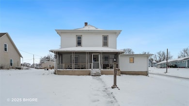
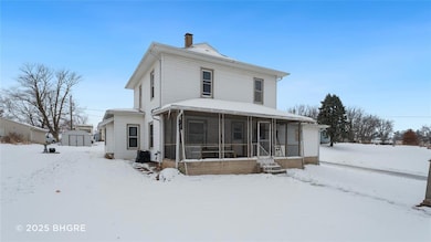
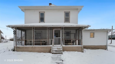
1002 Mcpherson St Casey, IA 50048
Guthrie County NeighborhoodEstimated payment $783/month
Highlights
- Mud Room
- Formal Dining Room
- 3-minute walk to Casey City Park
- No HOA
- Forced Air Heating and Cooling System
About This Home
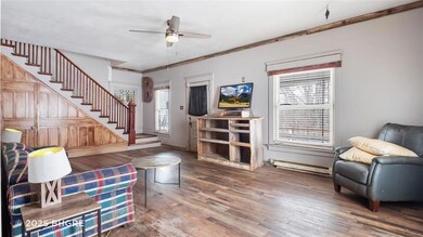
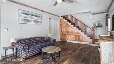
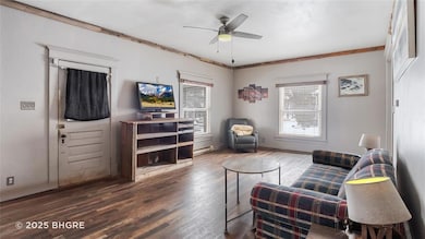
This charming two-story, four-bedroom home is full of character and offers a spacious, functional layout. The main floor features a large living room, dining room, and kitchen—all finished with durable LVP flooring. The eat-in kitchen provides abundant cabinet space and a convenient pantry, and it opens to a generous dining room complete with a cozy window seat. Upstairs, you’ll find three spacious bedrooms with beautiful original hardwood floors. Additional highlights include a garage with a mudroom entry directly into the kitchen. Ideal for those seeking a property with strong potential and room for value-boosting updates. Situated on a desirable corner lot, this home combines comfort, convenience, and classic charm.
Home Details
Home Type
- Single Family
Est. Annual Taxes
- $1,904
Year Built
- Built in 1915
Lot Details
- 0.27 Acre Lot
- Lot Dimensions are 65x180
Home Design
- Asphalt Shingled Roof
- Vinyl Siding
Interior Spaces
- 1,756 Sq Ft Home
- 2-Story Property
- Mud Room
- Formal Dining Room
- Unfinished Basement
Bedrooms and Bathrooms
- 1 Full Bathroom
Parking
- 2 Car Attached Garage
- Gravel Driveway
Utilities
- Forced Air Heating and Cooling System
Community Details
- No Home Owners Association
Listing and Financial Details
- Assessor Parcel Number 0001109600
Map
Home Values in the Area
Average Home Value in this Area
Tax History
| Year | Tax Paid | Tax Assessment Tax Assessment Total Assessment is a certain percentage of the fair market value that is determined by local assessors to be the total taxable value of land and additions on the property. | Land | Improvement |
|---|---|---|---|---|
| 2025 | $1,708 | $113,600 | $10,700 | $102,900 |
| 2024 | $1,708 | $99,100 | $7,200 | $91,900 |
| 2023 | $1,836 | $99,100 | $7,200 | $91,900 |
| 2022 | $1,782 | $77,200 | $7,200 | $70,000 |
| 2021 | $1,782 | $77,200 | $7,200 | $70,000 |
| 2020 | $680 | $71,600 | $7,200 | $64,400 |
| 2019 | $900 | $70,800 | $0 | $0 |
| 2018 | $1,314 | $70,800 | $0 | $0 |
| 2017 | $1,314 | $60,300 | $0 | $0 |
| 2016 | $1,138 | $60,300 | $0 | $0 |
| 2015 | $1,084 | $56,682 | $0 | $0 |
| 2014 | $1,030 | $56,682 | $0 | $0 |
Property History
| Date | Event | Price | List to Sale | Price per Sq Ft |
|---|---|---|---|---|
| 12/10/2025 12/10/25 | For Sale | $119,000 | -- | $68 / Sq Ft |
Purchase History
| Date | Type | Sale Price | Title Company |
|---|---|---|---|
| Quit Claim Deed | -- | None Available | |
| Warranty Deed | $54,000 | None Available |
Mortgage History
| Date | Status | Loan Amount | Loan Type |
|---|---|---|---|
| Previous Owner | $80,000 | Credit Line Revolving |
Source: Des Moines Area Association of REALTORS®
MLS Number: 731459
APN: 0001109600
Disclaimer: Certain information contained herein is derived from information provided by parties other than Homes.com. All information provided is deemed reliable, but is not guaranteed to be accurate and should be independently verified.
![]() IDX information is provided exclusively for personal, non-commercial use, and may not be used for any purpose other than to identify prospective properties consumers may be interested in purchasing. Information is deemed reliable but not guaranteed.
IDX information is provided exclusively for personal, non-commercial use, and may not be used for any purpose other than to identify prospective properties consumers may be interested in purchasing. Information is deemed reliable but not guaranteed.
