Estimated Value: $248,000 - $285,000
4
Beds
3
Baths
2,385
Sq Ft
$112/Sq Ft
Est. Value
About This Home
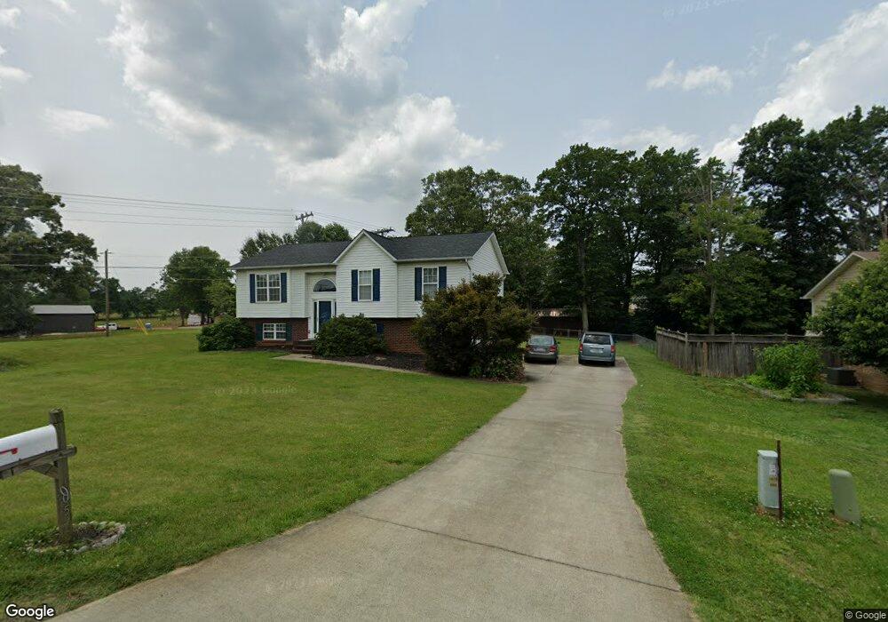
This home is located at 1005 Laurel Crest Rd, King, NC 27021 and is currently estimated at $266,494, approximately $111 per square foot. 1005 Laurel Crest Rd is a home located in Stokes County with nearby schools including Poplar Springs Elementary School, Chestnut Grove Middle, and West Stokes High.
Ownership History
Date
Name
Owned For
Owner Type
Purchase Details
Closed on
Oct 10, 2005
Sold by
Thomas Susan A
Bought by
Smith James M and Smith Cynthia M
Current Estimated Value
Home Financials for this Owner
Home Financials are based on the most recent Mortgage that was taken out on this home.
Original Mortgage
$55,000
Outstanding Balance
$29,364
Interest Rate
5.72%
Mortgage Type
New Conventional
Estimated Equity
$237,130
Purchase Details
Closed on
Apr 8, 2005
Sold by
Town & Country Builders Of Mount Airy In
Bought by
Thomas Susan A
Home Financials for this Owner
Home Financials are based on the most recent Mortgage that was taken out on this home.
Original Mortgage
$120,410
Interest Rate
5.62%
Mortgage Type
FHA
Create a Home Valuation Report for This Property
The Home Valuation Report is an in-depth analysis detailing your home's value as well as a comparison with similar homes in the area
Home Values in the Area
Average Home Value in this Area
Purchase History
| Date | Buyer | Sale Price | Title Company |
|---|---|---|---|
| Smith James M | $125,000 | None Available | |
| Thomas Susan A | $122,500 | None Available | |
| Town & Country Builders Of Mount Airy In | -- | None Available |
Source: Public Records
Mortgage History
| Date | Status | Borrower | Loan Amount |
|---|---|---|---|
| Open | Smith James M | $55,000 | |
| Previous Owner | Thomas Susan A | $120,410 |
Source: Public Records
Tax History
| Year | Tax Paid | Tax Assessment Tax Assessment Total Assessment is a certain percentage of the fair market value that is determined by local assessors to be the total taxable value of land and additions on the property. | Land | Improvement |
|---|---|---|---|---|
| 2025 | $1,703 | $238,200 | $35,000 | $203,200 |
| 2024 | $1,703 | $165,600 | $28,000 | $137,600 |
| 2023 | $1,341 | $165,600 | $28,000 | $137,600 |
| 2022 | $1,225 | $165,600 | $28,000 | $137,600 |
| 2021 | $1,225 | $165,600 | $28,000 | $137,600 |
| 2020 | $1,061 | $143,400 | $25,000 | $118,400 |
| 2019 | $1,061 | $143,400 | $25,000 | $118,400 |
| 2018 | $1,061 | $143,400 | $25,000 | $118,400 |
| 2017 | $1,054 | $143,400 | $25,000 | $118,400 |
| 2016 | $1,026 | $139,600 | $25,000 | $114,600 |
| 2015 | $1,019 | $139,600 | $25,000 | $114,600 |
| 2014 | $971 | $139,600 | $25,000 | $114,600 |
Source: Public Records
Map
Nearby Homes
- 100 Ridgecrest Dr
- 101 Ravenwood Ct
- 1110 Foxtrot Ct
- 113 Ravenwood Ct
- 103 Jasper Ct
- 310 Cedardale Ln
- 1255 Mountain View Rd
- 1739 Denny Rd
- Lot 19 Glen Brooke Ln
- Lot 18 Glen Brooke Ln
- 109 Glen Brooke Ln
- Lot 9 Brown Rd
- 157 Leeds Ln
- Lot 10 Brown Rd
- 1034 Kentland Dr
- 254 Winfield Dr
- 0 Mountain View Rd Unit 1173137
- 104 Palomino Dr
- 1129 Kentland Dr
- 218 Maverick Trail Dr
- 1015 Laurel Crest Rd
- 1025 Laurel Crest Rd
- 6061 Nc 66 Hwy S
- 6061 Nc 66 Hwy S
- 1020 Laurel Crest Rd
- 1010 Laurel Bluff Dr
- 1020 Laurel Bluff Dr
- 1035 Laurel Crest Rd
- 6070 Nc Highway 66 S
- 1030 Laurel Crest Rd
- 6020 Nc 66 Hwy S
- 1045 Laurel Crest Rd
- 6081 N Carolina 66
- 6076 Nc 66 Hwy S
- 1040 Laurel Crest Rd
- 6081 Nc 66 Hwy S
- 1030 Apple Ridge Rd
- 1055 Laurel Crest Rd
- 1030 Laurel Bluff Dr
Your Personal Tour Guide
Ask me questions while you tour the home.