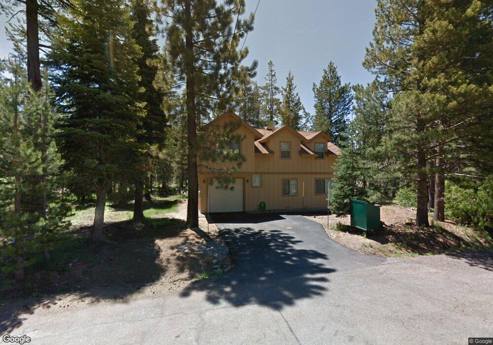
1006 Crow St South Lake Tahoe, CA 96150
Estimated Value: $617,176 - $832,000
4
Beds
3
Baths
1,987
Sq Ft
$362/Sq Ft
Est. Value
About This Home
This home is located at 1006 Crow St, South Lake Tahoe, CA 96150 and is currently estimated at $719,544, approximately $362 per square foot. 1006 Crow St is a home located in El Dorado County with nearby schools including Tahoe Valley Elementary School, South Tahoe Middle School, and South Tahoe High School.
Ownership History
Date
Name
Owned For
Owner Type
Purchase Details
Closed on
Feb 21, 2017
Sold by
Paslin David A and David A Paslin Living Trust
Bought by
Becker Becker Deborah Paslin Deborah Paslin and Becker Morgan C
Current Estimated Value
Purchase Details
Closed on
Sep 6, 2013
Sold by
Paslin David A
Bought by
Paslin David A and David A Paslin Living Trust
Purchase Details
Closed on
Apr 24, 1995
Sold by
Segall Reva A
Bought by
Segall John B and Segall Reva A
Create a Home Valuation Report for This Property
The Home Valuation Report is an in-depth analysis detailing your home's value as well as a comparison with similar homes in the area
Home Values in the Area
Average Home Value in this Area
Purchase History
| Date | Buyer | Sale Price | Title Company |
|---|---|---|---|
| Becker Becker Deborah Paslin Deborah Paslin | -- | None Available | |
| Paslin David A | -- | None Available | |
| Segall John B | -- | -- |
Source: Public Records
Tax History Compared to Growth
Tax History
| Year | Tax Paid | Tax Assessment Tax Assessment Total Assessment is a certain percentage of the fair market value that is determined by local assessors to be the total taxable value of land and additions on the property. | Land | Improvement |
|---|---|---|---|---|
| 2025 | $1,578 | $140,255 | $10,348 | $129,907 |
| 2024 | $1,578 | $137,506 | $10,146 | $127,360 |
| 2023 | $1,552 | $134,811 | $9,948 | $124,863 |
| 2022 | $1,537 | $132,168 | $9,753 | $122,415 |
| 2021 | $1,511 | $129,577 | $9,562 | $120,015 |
| 2020 | $1,493 | $128,249 | $9,464 | $118,785 |
| 2019 | $1,486 | $125,735 | $9,279 | $116,456 |
| 2018 | $1,454 | $123,271 | $9,098 | $114,173 |
| 2017 | $1,433 | $120,855 | $8,920 | $111,935 |
| 2016 | $1,405 | $118,487 | $8,746 | $109,741 |
| 2015 | $1,337 | $116,709 | $8,615 | $108,094 |
| 2014 | $1,337 | $114,426 | $8,448 | $105,978 |
Source: Public Records
Map
Nearby Homes
- 1085 Mulberry Dr
- 1140 Sioux St
- 1982 Cherokee St
- 2113 Oaxaco St
- 0 Tomahawk Ln
- 2182 Lindenwood Dr
- 2189 Cornelian Dr
- 2181 Pinewood Dr
- 2255 Blitzen Rd
- 2263 Blitzen Rd
- 1871 Normuk St
- 1889 Normuk St
- 1894 Normuk St
- 1935 Apache Ave
- 1940 Apache Ave
- 2877 Us Highway 50
- 1444 Apache Ave
- 1502 Seminole Dr
- 1666 Arapahoe St
- 1774 Delaware St