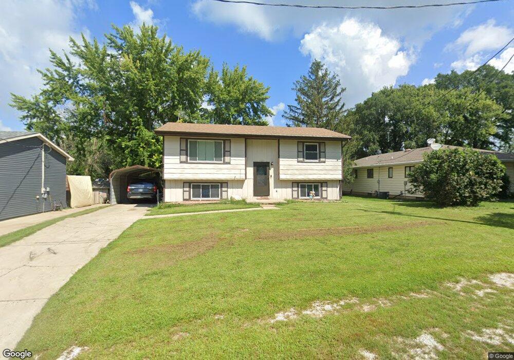
1007 Clinton St Dunlap, IA 51529
Estimated Value: $122,000 - $154,000
4
Beds
2
Baths
869
Sq Ft
$156/Sq Ft
Est. Value
About This Home
This home is located at 1007 Clinton St, Dunlap, IA 51529 and is currently estimated at $135,962, approximately $156 per square foot. 1007 Clinton St is a home located in Harrison County with nearby schools including Boyer Valley Elementary School and Boyer Valley Middle/High School.
Ownership History
Date
Name
Owned For
Owner Type
Purchase Details
Closed on
Jul 13, 2023
Sold by
Williams Dale L and Williams Nancy K
Bought by
M & D Williams Properties Llc
Current Estimated Value
Home Financials for this Owner
Home Financials are based on the most recent Mortgage that was taken out on this home.
Original Mortgage
$93,750
Outstanding Balance
$91,514
Interest Rate
6.79%
Mortgage Type
New Conventional
Estimated Equity
$44,448
Create a Home Valuation Report for This Property
The Home Valuation Report is an in-depth analysis detailing your home's value as well as a comparison with similar homes in the area
Home Values in the Area
Average Home Value in this Area
Purchase History
| Date | Buyer | Sale Price | Title Company |
|---|---|---|---|
| M & D Williams Properties Llc | $125,500 | None Listed On Document |
Source: Public Records
Mortgage History
| Date | Status | Borrower | Loan Amount |
|---|---|---|---|
| Open | M & D Williams Properties Llc | $93,750 |
Source: Public Records
Tax History Compared to Growth
Tax History
| Year | Tax Paid | Tax Assessment Tax Assessment Total Assessment is a certain percentage of the fair market value that is determined by local assessors to be the total taxable value of land and additions on the property. | Land | Improvement |
|---|---|---|---|---|
| 2025 | $1,870 | $113,690 | $11,340 | $102,350 |
| 2024 | $1,870 | $103,850 | $11,340 | $92,510 |
| 2023 | $1,616 | $103,850 | $11,340 | $92,510 |
| 2022 | $1,568 | $90,953 | $11,340 | $79,613 |
| 2021 | $1,568 | $90,953 | $11,340 | $79,613 |
| 2020 | $1,404 | $78,234 | $11,340 | $66,894 |
| 2019 | $1,394 | $78,234 | $11,340 | $66,894 |
| 2018 | $1,382 | $73,285 | $0 | $0 |
| 2017 | $1,426 | $73,285 | $0 | $0 |
| 2016 | $1,402 | $73,285 | $0 | $0 |
| 2015 | $1,402 | $66,022 | $0 | $0 |
| 2014 | $1,300 | $66,022 | $0 | $0 |
Source: Public Records
Map
Nearby Homes
- 1403 Eaton St
- 202 Y St
- 32055 Spruce Ave
- 1110 Street F16
- 2074 U Ave
- 2590 220th St
- 211 Brookview Dr
- 37 10th St
- 808 Park St
- 42 6th St
- 406 Weare St
- 102 Bluegrass Ln
- 101 Bluegrass Ln
- 907 Harvest Hills Dr
- 106 Bluegrass Ln
- 905 Harvest Hills Dr
- 903 Harvest Hills Dr
- 111 Ridgeline Rd
- 906 Harvest Hills Dr
- 305 Normal St
- 1005 Clinton St
- 401 N 11th St
- 401 N 11th St Unit Q
- 1003 Clinton St
- 1001 Clinton St
- 1101 Clinton St
- 1002 Clinton St
- 1006 Clinton St
- 307 N 11th St
- 403 N 10th St
- 308 N 10th St
- 308 N 11th St
- 311 N 10th St
- 1109 Clinton St
- 905 Clinton St
- 1009 Montague St
- 1005 Montague St
- 309 N 12th St
- 906 Clinton St
- 1001 Montague St