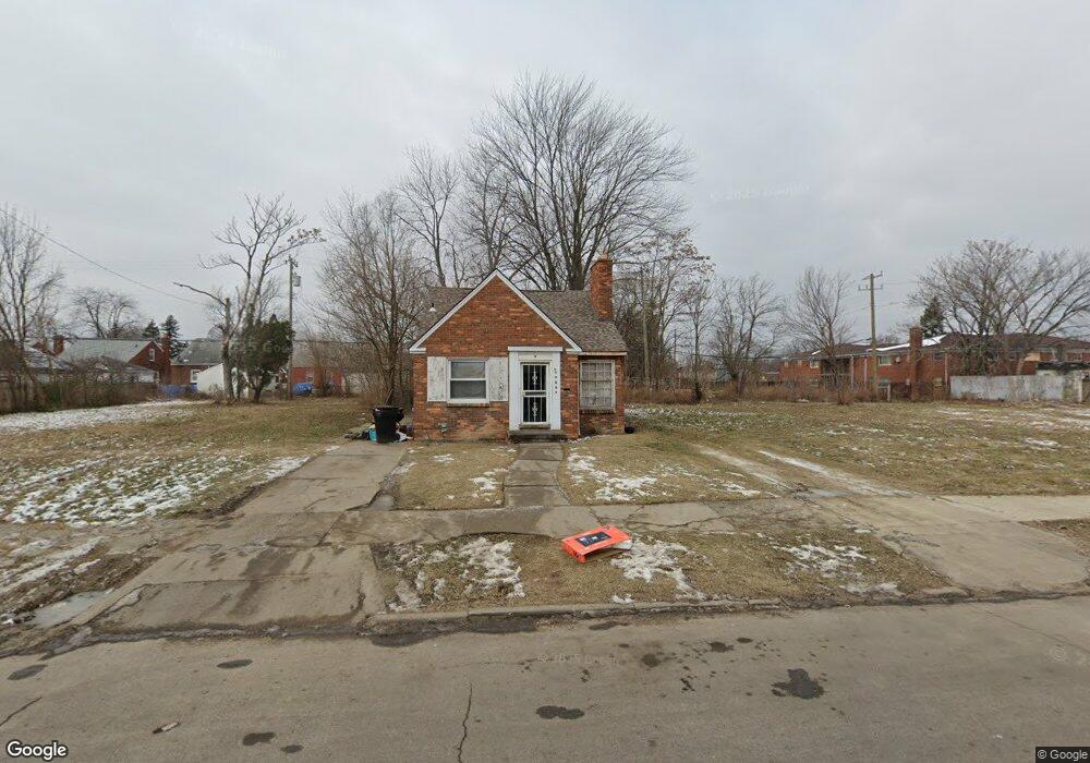
10073 Balfour Rd Detroit, MI 48224
Outer Drive-Hayes NeighborhoodEstimated Value: $51,000 - $76,000
3
Beds
2
Baths
1,011
Sq Ft
$63/Sq Ft
Est. Value
About This Home
This home is located at 10073 Balfour Rd, Detroit, MI 48224 and is currently estimated at $63,500, approximately $62 per square foot. 10073 Balfour Rd is a home located in Wayne County with nearby schools including Wayne Elementary School, Edward 'Duke' Ellington Conservatory of Music and Art, and Charles L. Spain Elementary-Middle School.
Ownership History
Date
Name
Owned For
Owner Type
Purchase Details
Closed on
Jan 6, 2015
Sold by
Treasurer Of The Charter County Of Wayne
Bought by
Detroit Land Bank Authority
Current Estimated Value
Purchase Details
Closed on
May 13, 2011
Sold by
Balfour 10073 Llc
Bought by
Nsuk3 Llc
Purchase Details
Closed on
Apr 23, 2010
Sold by
Rbs Citizens Na
Bought by
Federal National Mortgage Association
Purchase Details
Closed on
Apr 21, 2010
Sold by
Palchaudhuri Sunil and Charter One Bank Na
Bought by
Rbs Citizens Na and Citizens Bank Na
Create a Home Valuation Report for This Property
The Home Valuation Report is an in-depth analysis detailing your home's value as well as a comparison with similar homes in the area
Home Values in the Area
Average Home Value in this Area
Purchase History
| Date | Buyer | Sale Price | Title Company |
|---|---|---|---|
| Detroit Land Bank Authority | -- | None Available | |
| Nsuk3 Llc | -- | Continental Title Agency | |
| Federal National Mortgage Association | -- | None Available | |
| Rbs Citizens Na | $3,400 | None Available |
Source: Public Records
Tax History Compared to Growth
Tax History
| Year | Tax Paid | Tax Assessment Tax Assessment Total Assessment is a certain percentage of the fair market value that is determined by local assessors to be the total taxable value of land and additions on the property. | Land | Improvement |
|---|---|---|---|---|
| 2025 | -- | $0 | $0 | $0 |
| 2024 | -- | $0 | $0 | $0 |
| 2023 | $0 | $0 | $0 | $0 |
| 2022 | -- | $0 | $0 | $0 |
| 2021 | $0 | $0 | $0 | $0 |
| 2020 | $0 | $0 | $0 | $0 |
| 2019 | $1,699 | $0 | $0 | $0 |
| 2018 | $0 | $0 | $0 | $0 |
| 2017 | $1,070 | $0 | $0 | $0 |
| 2016 | $240 | $10,700 | $0 | $0 |
| 2015 | $1,070 | $10,700 | $0 | $0 |
| 2013 | $1,490 | $14,900 | $0 | $0 |
| 2010 | -- | $27,895 | $1,099 | $26,796 |
Source: Public Records
Map
Nearby Homes
- 10172 Somerset Ave
- 10029 Balfour Rd
- 10390 Somerset Ave
- 10468 Nottingham Rd
- 10404 Somerset Ave
- 9610 Whittier St
- 10508 Nottingham Rd
- 9801 Kensington Ave
- 10597 Beaconsfield St
- 9344 Courville St
- 9510 Whittier St
- 10731 Roxbury St
- 10345 Greensboro St
- 10551 Somerset Ave
- 10446 Balfour Rd
- 10713 Beaconsfield St
- 10253 Mckinney St
- 10521 Roxbury St
- 10811 Roxbury St
- 9265 Bedford St
- 10079 Balfour Rd
- 10065 Balfour Rd
- 10166 Somerset Ave
- 10087 Balfour Rd
- 10059 Balfour Rd
- 10158 Somerset Ave
- 10186 Somerset Ave
- 10051 Balfour Rd
- 10152 Somerset Ave
- 10045 Balfour Rd
- 10144 Somerset Ave
- 10039 Balfour Rd
- 10136 Somerset Ave
- 10223 Whittier Ave
- 10201 Whittier St
- 10235 Whittier St
- 10235 Whittier St
- 10235 Whittier St Unit 15
- 10235 Whittier St Unit 14
- 10235 Whittier St Unit 13