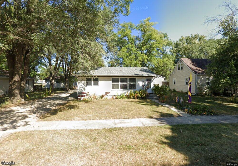
1008 10th St NE Mason City, IA 50401
Estimated Value: $76,000 - $125,000
2
Beds
1
Bath
1,536
Sq Ft
$60/Sq Ft
Est. Value
About This Home
This home is located at 1008 10th St NE, Mason City, IA 50401 and is currently estimated at $92,238, approximately $60 per square foot. 1008 10th St NE is a home located in Cerro Gordo County with nearby schools including Mason City High School, Mason City Seventh Day Adventi, and North Iowa Christian School.
Ownership History
Date
Name
Owned For
Owner Type
Purchase Details
Closed on
Jan 27, 2017
Sold by
Huntley Brian J and Huntley Sara R
Bought by
Mccoy Jon D and Mccoy Heather D
Current Estimated Value
Home Financials for this Owner
Home Financials are based on the most recent Mortgage that was taken out on this home.
Original Mortgage
$43,000
Outstanding Balance
$7,241
Interest Rate
4.2%
Mortgage Type
New Conventional
Estimated Equity
$84,998
Purchase Details
Closed on
Oct 8, 2014
Sold by
H & F Properties Llc
Bought by
Huntley Brian J and Huntley Sara H
Purchase Details
Closed on
Jan 12, 2007
Sold by
Huff Sandra K and Fournier Bruce A
Bought by
H & F Properties Llc
Purchase Details
Closed on
Dec 12, 2006
Sold by
Bratrud Allan D and Bratrud Dorothy H
Bought by
H & F Properties Llc
Create a Home Valuation Report for This Property
The Home Valuation Report is an in-depth analysis detailing your home's value as well as a comparison with similar homes in the area
Home Values in the Area
Average Home Value in this Area
Purchase History
| Date | Buyer | Sale Price | Title Company |
|---|---|---|---|
| Mccoy Jon D | -- | None Available | |
| Huntley Brian J | $37,100 | None Available | |
| H & F Properties Llc | -- | None Available | |
| H & F Properties Llc | $88,000 | None Available |
Source: Public Records
Mortgage History
| Date | Status | Borrower | Loan Amount |
|---|---|---|---|
| Open | Mccoy Jon D | $43,000 |
Source: Public Records
Tax History Compared to Growth
Tax History
| Year | Tax Paid | Tax Assessment Tax Assessment Total Assessment is a certain percentage of the fair market value that is determined by local assessors to be the total taxable value of land and additions on the property. | Land | Improvement |
|---|---|---|---|---|
| 2024 | $884 | $65,470 | $19,030 | $46,440 |
| 2023 | $1,026 | $65,470 | $19,030 | $46,440 |
| 2022 | $1,036 | $60,740 | $14,650 | $46,090 |
| 2021 | $908 | $59,270 | $14,650 | $44,620 |
| 2020 | $1,094 | $50,460 | $14,650 | $35,810 |
| 2019 | $834 | $0 | $0 | $0 |
| 2018 | $866 | $0 | $0 | $0 |
| 2017 | $886 | $0 | $0 | $0 |
| 2016 | $864 | $0 | $0 | $0 |
| 2015 | $864 | $0 | $0 | $0 |
| 2014 | $1,182 | $0 | $0 | $0 |
| 2013 | -- | $0 | $0 | $0 |
Source: Public Records
Map
Nearby Homes
- 110 N Kentucky Ave
- 1021 12th St NE
- 938 12th St NE
- 1100 N Tennessee Place
- 807 10th St NE
- 1368 12th St NE
- 1416 N Kentucky Ave
- 1419 N Kentucky Ave
- 1306 N Rhode Island Ave
- 726 11th St NE
- 1008 N Hampshire Ave
- 663 10th St NE
- 534 River Bend Ct
- 1551 N Rhode Island Ave
- 1533 Plymouth Rd
- 705 15th Place NE
- 682 3rd St NE
- 680 3rd St NE
- 22 Asbury Place Unit Boulder Road
- 1538 N Hampshire Ave
- 1014 10th St NE
- 1003 N Kentucky Ave
- 1020 10th St NE
- 1007 10th St NE
- 1015 10th St NE
- 921 N Kentucky Ave
- 948 10th St NE
- 1019 10th St NE
- 1021 N Kentucky Ave
- 1026 10th St NE
- 1007 11th St NE
- 1013 11th St NE
- 942 10th St NE
- 1025 10th St NE
- 1021 11th St NE
- 1032 10th St NE
- 945 10th St NE
- 945 11th St NE
- 941 10th St NE
- 938 10th St NE