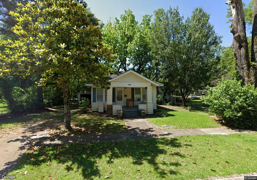
1008 E Broad St West Point, MS 39773
Estimated Value: $102,381 - $108,000
2
Beds
--
Bath
1,035
Sq Ft
$101/Sq Ft
Est. Value
About This Home
This home is located at 1008 E Broad St, West Point, MS 39773 and is currently estimated at $104,595, approximately $101 per square foot. 1008 E Broad St is a home located in Clay County with nearby schools including East Side Elementary School, West Clay Elementary School, and Church Hill Elementary School.
Ownership History
Date
Name
Owned For
Owner Type
Purchase Details
Closed on
Apr 9, 2024
Sold by
J And B Food Market Llc
Bought by
Patel Nimesh Pravinkumar and Patel Ashaben Nimesh
Current Estimated Value
Purchase Details
Closed on
Aug 12, 2022
Sold by
Clay County Mississippi
Bought by
Patel Nimesh Pravinkumar and Patel Ashaben Nimesh
Purchase Details
Closed on
Aug 2, 2022
Sold by
Patel Nimesh Pravinkumar
Bought by
Patel Nimesh Pravinkumar and Patel Ashaben Nimesh
Purchase Details
Closed on
Dec 19, 2018
Sold by
Terrell Thomas
Bought by
Charleys Pawn Shop Llc
Create a Home Valuation Report for This Property
The Home Valuation Report is an in-depth analysis detailing your home's value as well as a comparison with similar homes in the area
Purchase History
| Date | Buyer | Sale Price | Title Company |
|---|---|---|---|
| Patel Nimesh Pravinkumar | -- | None Listed On Document | |
| Patel Nimesh Pravinkumar | -- | Turner Law Offices Pllc | |
| Patel Nimesh Pravinkumar | -- | None Listed On Document | |
| Patel Nimesh Pravinkumar | -- | None Listed On Document | |
| Charleys Pawn Shop Llc | -- | -- |
Source: Public Records
Tax History
| Year | Tax Paid | Tax Assessment Tax Assessment Total Assessment is a certain percentage of the fair market value that is determined by local assessors to be the total taxable value of land and additions on the property. | Land | Improvement |
|---|---|---|---|---|
| 2025 | $540 | $9,949 | $3,997 | $5,952 |
| 2024 | $540 | $9,949 | $3,997 | $5,952 |
| 2023 | $913 | $6,098 | $1,361 | $4,737 |
| 2022 | $332 | $6,098 | $1,361 | $4,737 |
| 2021 | $332 | $6,098 | $1,361 | $4,737 |
| 2020 | $331 | $6,098 | $1,361 | $4,737 |
| 2019 | $313 | $6,055 | $1,361 | $4,694 |
| 2018 | $300 | $6,055 | $1,361 | $4,694 |
| 2017 | $300 | $6,055 | $1,361 | $4,694 |
| 2016 | $288 | $6,055 | $1,361 | $4,694 |
| 2015 | $276 | $5,606 | $1,361 | $4,245 |
| 2014 | -- | $5,606 | $1,361 | $4,245 |
| 2013 | -- | $5,606 | $1,361 | $4,245 |
Source: Public Records
Map
Nearby Homes
- 551 E Westbrook St
- 341 Mccord St
- 26596 E Main St
- 27045 E Main St
- 913 E Westbrook St
- 228 Mccord St
- 26852 E Main St
- 26788 E Main St
- 507 S Eshman Ave
- 105 Converse Dr
- 238 Calhoun St
- 472 S Eshman Ave
- 1046 E Brame Ave
- 405 S Eshman Ave
- 44 Torbert Dr
- 278 Converse Dr
- 761 E Morrow St
- 329 Converse Dr
- 530 E Morrow St
- 184 Tournament St
- 314 Miller Ave
- 326 Miller Ave
- 1016 E Broad St
- 442 Miller Ave
- 1028 E Broad St
- 1015 E Broad St
- 1242 E Broad St
- 1297 E Broad St
- 1003 E Broad St
- 319 Miller Ave
- 1017 E Westbrook St
- 1001 E Westbrook St
- 971 E Broad St
- 1025 E Westbrook St
- 1038 E Broad St
- 954 E Broad St
- 973 E Westbrook St
- 965 E Broad St
- 1031 E Westbrook St
- 1030 E Westbrook St
Your Personal Tour Guide
Ask me questions while you tour the home.