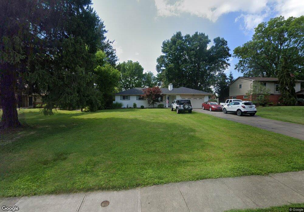
10085 Zig Zag Rd Blue Ash, OH 45242
Estimated Value: $357,319 - $435,000
3
Beds
2
Baths
1,194
Sq Ft
$330/Sq Ft
Est. Value
About This Home
This home is located at 10085 Zig Zag Rd, Blue Ash, OH 45242 and is currently estimated at $393,580, approximately $329 per square foot. 10085 Zig Zag Rd is a home located in Hamilton County with nearby schools including Edwin H Greene Intermediate Middle School, Sycamore Junior High School, and Sycamore High School.
Ownership History
Date
Name
Owned For
Owner Type
Purchase Details
Closed on
Feb 23, 1995
Sold by
Slater Alvin L
Bought by
Inman Ronald W and Inman Deborah Anne
Current Estimated Value
Home Financials for this Owner
Home Financials are based on the most recent Mortgage that was taken out on this home.
Original Mortgage
$92,000
Interest Rate
9.12%
Purchase Details
Closed on
Jul 27, 1994
Sold by
Slater Alvin L and Slater Marjorie J
Bought by
Slater Alvin L
Create a Home Valuation Report for This Property
The Home Valuation Report is an in-depth analysis detailing your home's value as well as a comparison with similar homes in the area
Home Values in the Area
Average Home Value in this Area
Purchase History
| Date | Buyer | Sale Price | Title Company |
|---|---|---|---|
| Inman Ronald W | -- | -- | |
| Slater Alvin L | -- | -- |
Source: Public Records
Mortgage History
| Date | Status | Borrower | Loan Amount |
|---|---|---|---|
| Closed | Inman Ronald W | $92,000 |
Source: Public Records
Tax History
| Year | Tax Paid | Tax Assessment Tax Assessment Total Assessment is a certain percentage of the fair market value that is determined by local assessors to be the total taxable value of land and additions on the property. | Land | Improvement |
|---|---|---|---|---|
| 2025 | $4,220 | $82,425 | $34,335 | $48,090 |
| 2024 | $4,122 | $82,425 | $34,335 | $48,090 |
| 2023 | $4,146 | $82,425 | $34,335 | $48,090 |
| 2022 | $4,953 | $82,160 | $37,769 | $44,391 |
| 2021 | $4,856 | $82,160 | $37,769 | $44,391 |
| 2020 | $4,898 | $82,160 | $37,769 | $44,391 |
| 2019 | $4,833 | $74,690 | $34,335 | $40,355 |
| 2018 | $4,659 | $74,690 | $34,335 | $40,355 |
| 2017 | $3,965 | $74,690 | $34,335 | $40,355 |
| 2016 | $3,522 | $64,016 | $19,149 | $44,867 |
| 2015 | $3,143 | $64,016 | $19,149 | $44,867 |
| 2014 | $3,154 | $64,016 | $19,149 | $44,867 |
| 2013 | $3,038 | $59,826 | $17,896 | $41,930 |
Source: Public Records
Map
Nearby Homes
- 5700 Samstone Ct
- 10019 Zig Zag Rd
- 10432 Hickory Point Dr
- 10489 Cinderella Dr
- 10550 Cinderella Dr
- 9850 Zig Zag Rd
- 9689 Cooper Ln
- 7835 Westwind Ln
- 7835 Pfeiffer Rd
- 10768 Fallsington Ct
- 7963 Mitchell Farm Ln
- 6250 Cooper Rd
- 7961 Elbrecht Dr
- 9500 Todd Dr
- 4270 Parkview Dr
- 4204 Magnolia Aly
- 4236 Parkview Dr
- 4234 Parkview Dr
- 4232 Parkview Dr
- 10089 Zig Zag Rd
- 10081 Zig Zag Rd
- 6010 Samstone Ct
- 6070 Samstone Ct
- 10093 Zig Zag Rd
- 10077 Zig Zag Rd
- 5960 Samstone Ct
- 10215 Kerrianna Dr
- 6150 Samstone Ct
- 10103 Zig Zag Rd
- 10084 Zig Zag Rd
- 10104 Zig Zag Rd
- 5910 Samstone Ct
- 10108 Zig Zag Rd
- 5860 Samstone Ct
- 10111 Zig Zag Rd
- 6069 Samstone Ct
- 6011 Samstone Ct
- 10112 Zig Zag Rd
- 5965 Samstone Ct
Your Personal Tour Guide
Ask me questions while you tour the home.