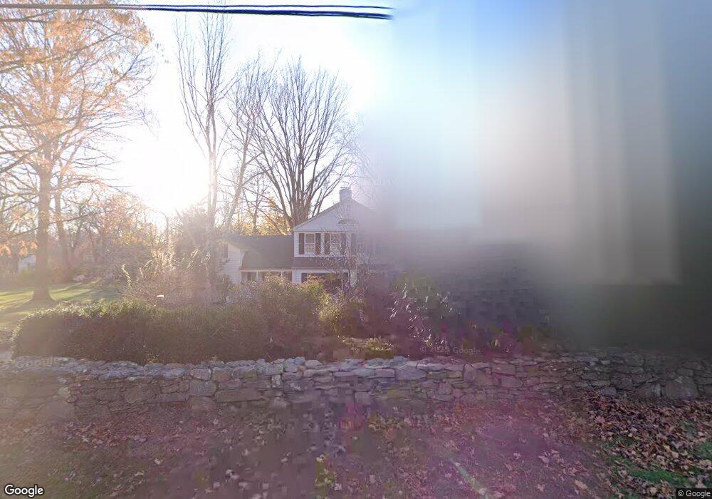
1009 Round Hill Rd Fairfield, CT 06824
University NeighborhoodEstimated Value: $1,571,623 - $1,920,000
3
Beds
5
Baths
2,878
Sq Ft
$606/Sq Ft
Est. Value
About This Home
This home is located at 1009 Round Hill Rd, Fairfield, CT 06824 and is currently estimated at $1,742,656, approximately $605 per square foot. 1009 Round Hill Rd is a home located in Fairfield County with nearby schools including Riverfield Elementary School, Roger Ludlowe Middle School, and Fairfield Ludlowe High School.
Ownership History
Date
Name
Owned For
Owner Type
Purchase Details
Closed on
Mar 3, 2006
Sold by
Liebman Leon
Bought by
Breen William P and Breen Margaret R
Current Estimated Value
Home Financials for this Owner
Home Financials are based on the most recent Mortgage that was taken out on this home.
Original Mortgage
$1,000,000
Outstanding Balance
$564,825
Interest Rate
6.16%
Estimated Equity
$1,177,831
Purchase Details
Closed on
May 15, 2001
Sold by
Nees Eugen C and Nees Dara K
Bought by
Liebman Leon
Purchase Details
Closed on
Sep 13, 1993
Sold by
Blase Robert Est
Bought by
Nees Eugene C and Nees Dara K
Create a Home Valuation Report for This Property
The Home Valuation Report is an in-depth analysis detailing your home's value as well as a comparison with similar homes in the area
Home Values in the Area
Average Home Value in this Area
Purchase History
| Date | Buyer | Sale Price | Title Company |
|---|---|---|---|
| Breen William P | $1,259,000 | -- | |
| Breen William P | $1,259,000 | -- | |
| Liebman Leon | $1,015,000 | -- | |
| Liebman Leon | $1,015,000 | -- | |
| Nees Eugene C | $541,000 | -- | |
| Nees Eugene C | $541,000 | -- |
Source: Public Records
Mortgage History
| Date | Status | Borrower | Loan Amount |
|---|---|---|---|
| Open | Nees Eugene C | $1,000,000 | |
| Closed | Nees Eugene C | $1,000,000 | |
| Previous Owner | Nees Eugene C | $450,000 |
Source: Public Records
Tax History Compared to Growth
Tax History
| Year | Tax Paid | Tax Assessment Tax Assessment Total Assessment is a certain percentage of the fair market value that is determined by local assessors to be the total taxable value of land and additions on the property. | Land | Improvement |
|---|---|---|---|---|
| 2025 | $18,583 | $654,570 | $317,870 | $336,700 |
| 2024 | $18,263 | $654,570 | $317,870 | $336,700 |
| 2023 | $18,007 | $654,570 | $317,870 | $336,700 |
| 2022 | $17,830 | $654,570 | $317,870 | $336,700 |
| 2021 | $17,660 | $654,570 | $317,870 | $336,700 |
| 2020 | $20,167 | $752,780 | $369,740 | $383,040 |
| 2019 | $20,167 | $752,780 | $369,740 | $383,040 |
| 2018 | $19,843 | $752,780 | $369,740 | $383,040 |
| 2017 | $19,437 | $752,780 | $369,740 | $383,040 |
| 2016 | $19,158 | $752,780 | $369,740 | $383,040 |
| 2015 | $20,737 | $836,500 | $364,210 | $472,290 |
| 2014 | $20,411 | $836,500 | $364,210 | $472,290 |
Source: Public Records
Map
Nearby Homes
- 105 Charter Oak Rd
- 44 Deer Run Rd
- 232 Pell Meadow Dr
- 168 Wormwood Rd
- 20 Ermine St
- 133 Green Acre Ln
- 15 Barton Rd
- 38 Edge Hill Rd
- 122 Colony St
- 360 Duck Farm Rd
- 33 Middlebrook Place
- 478 Crestwood Rd
- 245 Unquowa Rd Unit 34
- 245 Unquowa Rd Unit 11
- 245 Unquowa Rd Unit 33
- 338 Orchard Hill Ln
- 68 Figlar Ave
- 647 Bronson Rd
- 45 Robin Cir
- 42 Robin Cir
- 1041 Round Hill Rd
- 945 Round Hill Rd
- 1057 Round Hill Rd
- 999 Round Hill Rd
- 941 Round Hill Rd
- 1075 Round Hill Rd
- 953 Round Hill Rd
- 1091 Round Hill Rd
- 20 Old Barn Rd
- 1123 Round Hill Rd
- 56 Old Barn Rd
- 259 Taunton Rd
- 93 Sconset Dr
- 281 Taunton Rd
- 1161 Round Hill Rd
- 267 Taunton Rd
- 1145 Round Hill Rd
- 89 Sconset Dr
- 96 Sconset Dr
- 251 Taunton Rd