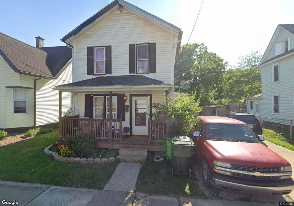
101 8th St SW Massillon, OH 44647
West Massillon NeighborhoodEstimated Value: $123,625 - $152,000
4
Beds
1
Bath
1,714
Sq Ft
$80/Sq Ft
Est. Value
About This Home
This home is located at 101 8th St SW, Massillon, OH 44647 and is currently estimated at $137,406, approximately $80 per square foot. 101 8th St SW is a home located in Stark County with nearby schools including Massillon Intermediate School, Massillon Junior High School, and Washington High School.
Ownership History
Date
Name
Owned For
Owner Type
Purchase Details
Closed on
Jun 26, 2012
Sold by
Rent Of Own Lesing Co Inc
Bought by
Baker Mathew A
Current Estimated Value
Purchase Details
Closed on
Apr 15, 2008
Sold by
Citifinancial Inc
Bought by
Rent To Own Leasing Co Inc
Purchase Details
Closed on
Dec 11, 2007
Sold by
Stevens Kenneth K and Stevens Wendy R
Bought by
Citifinancial Inc
Purchase Details
Closed on
Jun 19, 2000
Sold by
Stevens Johnny W and Stevens Deborah K
Bought by
Stevens Kenneth J and Stevens Wendy R
Create a Home Valuation Report for This Property
The Home Valuation Report is an in-depth analysis detailing your home's value as well as a comparison with similar homes in the area
Home Values in the Area
Average Home Value in this Area
Purchase History
| Date | Buyer | Sale Price | Title Company |
|---|---|---|---|
| Baker Mathew A | -- | None Available | |
| Rent To Own Leasing Co Inc | $23,400 | Resource Title Agency Inc | |
| Citifinancial Inc | $50,000 | None Available | |
| Stevens Kenneth J | -- | -- |
Source: Public Records
Tax History Compared to Growth
Tax History
| Year | Tax Paid | Tax Assessment Tax Assessment Total Assessment is a certain percentage of the fair market value that is determined by local assessors to be the total taxable value of land and additions on the property. | Land | Improvement |
|---|---|---|---|---|
| 2025 | -- | $37,730 | $8,190 | $29,540 |
| 2024 | -- | $37,730 | $8,190 | $29,540 |
| 2023 | $1,735 | $27,170 | $6,550 | $20,620 |
| 2022 | $697 | $27,170 | $6,550 | $20,620 |
| 2021 | $1,761 | $27,170 | $6,550 | $20,620 |
| 2020 | $1,223 | $22,060 | $5,360 | $16,700 |
| 2019 | $1,884 | $22,060 | $5,360 | $16,700 |
| 2018 | $1,582 | $22,060 | $5,360 | $16,700 |
| 2017 | $1,179 | $20,280 | $4,030 | $16,250 |
| 2016 | $1,199 | $20,280 | $4,030 | $16,250 |
| 2015 | $1,184 | $20,280 | $4,030 | $16,250 |
| 2014 | $1,184 | $19,610 | $3,890 | $15,720 |
| 2013 | $596 | $19,610 | $3,890 | $15,720 |
Source: Public Records
Map
Nearby Homes
- 508 Tremont Ave SW
- 504 5th St SW
- 1301 Lincoln Way NW
- 532 4th St SW
- 827 9th St SW
- 315 14th St SW
- 101 14th St NW
- 309 15th St NW
- 878 Liberty Ct SW
- 718 Bebb Ave SW
- 533 Webb Ave SW
- 1737 Leslie St NW
- 3414 Joyce Ave NW Unit 18
- Lot 42 Joyce Ave NW
- 3447 Marys Way Ave NW
- 3476 Joyce Ave NW Unit 15
- 620 1st St NW
- 1104 4th St SW
- 202 Rose Ave SE
- 313 2nd St NE