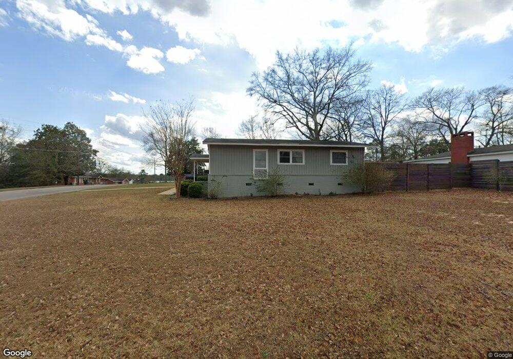
101 Andrews St Enterprise, AL 36330
Estimated Value: $94,000 - $127,000
3
Beds
1
Bath
1,050
Sq Ft
$103/Sq Ft
Est. Value
About This Home
This home is located at 101 Andrews St, Enterprise, AL 36330 and is currently estimated at $108,659, approximately $103 per square foot. 101 Andrews St is a home located in Coffee County with nearby schools including Hillcrest Elementary School, Dauphin Junior High School, and Enterprise High School.
Ownership History
Date
Name
Owned For
Owner Type
Purchase Details
Closed on
Jul 3, 2025
Sold by
Howell Roger
Bought by
Howell James and Howell Vanessa F
Current Estimated Value
Home Financials for this Owner
Home Financials are based on the most recent Mortgage that was taken out on this home.
Original Mortgage
$80,000
Outstanding Balance
$79,449
Interest Rate
6.01%
Mortgage Type
New Conventional
Estimated Equity
$29,210
Purchase Details
Closed on
Sep 17, 2019
Sold by
Equity Trust Co
Bought by
Howell Roger
Create a Home Valuation Report for This Property
The Home Valuation Report is an in-depth analysis detailing your home's value as well as a comparison with similar homes in the area
Home Values in the Area
Average Home Value in this Area
Purchase History
| Date | Buyer | Sale Price | Title Company |
|---|---|---|---|
| Howell James | $100,000 | None Listed On Document | |
| Howell James | $100,000 | None Listed On Document | |
| Howell Roger | -- | None Available |
Source: Public Records
Mortgage History
| Date | Status | Borrower | Loan Amount |
|---|---|---|---|
| Open | Howell James | $80,000 | |
| Closed | Howell James | $80,000 |
Source: Public Records
Tax History Compared to Growth
Tax History
| Year | Tax Paid | Tax Assessment Tax Assessment Total Assessment is a certain percentage of the fair market value that is determined by local assessors to be the total taxable value of land and additions on the property. | Land | Improvement |
|---|---|---|---|---|
| 2024 | $658 | $14,440 | $3,602 | $10,838 |
| 2023 | $626 | $12,778 | $3,600 | $9,178 |
| 2022 | $586 | $12,780 | $0 | $0 |
| 2021 | $522 | $11,320 | $0 | $0 |
| 2020 | $522 | $11,320 | $0 | $0 |
| 2019 | $520 | $11,260 | $0 | $0 |
| 2018 | $520 | $11,260 | $0 | $0 |
| 2017 | $550 | $11,960 | $0 | $0 |
| 2016 | $550 | $11,960 | $0 | $0 |
| 2015 | $550 | $11,960 | $0 | $0 |
| 2014 | $550 | $11,960 | $0 | $0 |
| 2011 | -- | $11,740 | $0 | $0 |
Source: Public Records
Map
Nearby Homes
- 103 Andrews St
- 406 Gibson St
- 105 Feagin St
- 814 E Lee St
- TBD Lester Dr
- 103 Candy Dr
- 208 Colony Dr
- 307 Colony Dr
- 309 Colony Dr
- 213 Cherryhill Rd
- 635 Glover Ave
- 109 Forest Ave
- 406 & 408 Glover Ave
- 119 Birchwood Place
- 212 Sylvan Dr
- 204 Holly Hill Rd
- 211 E Watts St
- 308 Loyola Dr
- 113 Weeks Dr
- 602 Cedar Dr