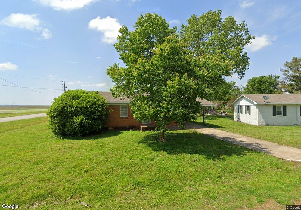
101 Laurel St Wilson, AR 72395
Estimated Value: $54,000 - $139,000
Studio
--
Bath
1,013
Sq Ft
$88/Sq Ft
Est. Value
About This Home
This home is located at 101 Laurel St, Wilson, AR 72395 and is currently estimated at $89,294, approximately $88 per square foot. 101 Laurel St is a home located in Mississippi County with nearby schools including Rivercrest Elementary School and The Delta School.
Ownership History
Date
Name
Owned For
Owner Type
Purchase Details
Closed on
Jan 2, 2014
Sold by
M K W Assn Of Farmers
Bought by
Lawrence Land Holdings Llc
Current Estimated Value
Purchase Details
Closed on
Jan 1, 2014
Sold by
M K W Assn Of Farmers
Bought by
Lawrence Land Holdings Llc
Purchase Details
Closed on
Jan 2, 1976
Sold by
Fha
Bought by
M K W Assn Of Farmers
Purchase Details
Closed on
Jan 1, 1976
Sold by
Fha
Bought by
M K W Assn Of Farmers
Purchase Details
Closed on
Jan 2, 1974
Sold by
Thompson Scottie
Bought by
Fha
Purchase Details
Closed on
Jan 1, 1974
Sold by
Thompson Scottie
Bought by
Fha
Purchase Details
Closed on
Jan 2, 1972
Sold by
M K W Assn Of Farmers
Bought by
Thompson Scottie
Purchase Details
Closed on
Jan 1, 1972
Sold by
M K W Assn Of Farmers
Bought by
Thompson Scottie
Purchase Details
Closed on
Jan 1, 1951
Bought by
Lee Wilson Company
Create a Home Valuation Report for This Property
The Home Valuation Report is an in-depth analysis detailing your home's value as well as a comparison with similar homes in the area
Purchase History
| Date | Buyer | Sale Price | Title Company |
|---|---|---|---|
| Lawrence Land Holdings Llc | $147,000 | -- | |
| Lawrence Land Holdings Llc | $147,000 | -- | |
| M K W Assn Of Farmers | -- | -- | |
| M K W Assn Of Farmers | -- | -- | |
| Fha | -- | -- | |
| Fha | -- | -- | |
| Thompson Scottie | -- | -- | |
| Thompson Scottie | -- | -- | |
| Lee Wilson Company | -- | -- |
Source: Public Records
Tax History
| Year | Tax Paid | Tax Assessment Tax Assessment Total Assessment is a certain percentage of the fair market value that is determined by local assessors to be the total taxable value of land and additions on the property. | Land | Improvement |
|---|---|---|---|---|
| 2025 | $256 | $4,887 | $600 | $4,287 |
| 2024 | $233 | $4,887 | $600 | $4,287 |
| 2023 | $233 | $4,887 | $600 | $4,287 |
| 2022 | $233 | $4,887 | $600 | $4,287 |
Source: Public Records
Map
Nearby Homes
- 7 Monroe St
- 65 Adams St
- 210 Cypress St
- 10 Crosstown Rd
- 309 Senter Ave
- 310 Pine St
- 1 Cedar St
- 1391 S Highway 136
- 500 Hill St
- 0 Shippen Ave Unit 22016399
- 0 E Johnson Ave
- 1 State Highway 140
- 0 State Highway 140
- 1798 E Co Road 952
- 132 Ken Dr
- 130 Diane Dr
- 0 Cheryl Unit 43977
- 105 E Alicia St
- 109 Newport Dr
- 111 Colonial Rd
- 103 Laurel St
- 202 Raintree Dr
- 100 Laurel St
- 105 Laurel St
- 102 Laurel St
- 206 Raintree Dr
- 208 Raintree Dr
- 107 Laurel St
- 106 Laurel St
- 210 Raintree Dr
- 207 Raintree Dr
- 209 Raintree Dr
- 226 State Highway 14
- 244 State Highway 14
- 157 Highway 14
- 250 State Highway 14
- 1097 W State Highway 119
- 3992 S County Road 391
- 280 State Highway 14
- 3978 S County Road 391
Your Personal Tour Guide
Ask me questions while you tour the home.