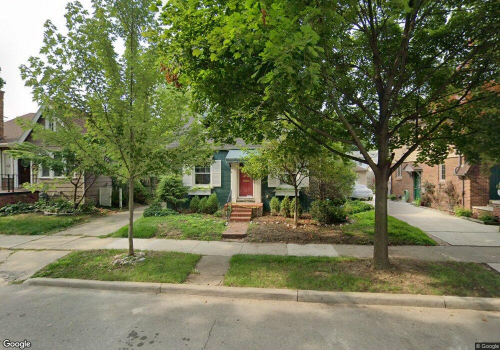
101 Mapleton Rd Unit Bldg-Unit Grosse Pointe Farms, MI 48236
Estimated Value: $423,000 - $553,000
Studio
2
Baths
1,272
Sq Ft
$395/Sq Ft
Est. Value
About This Home
This home is located at 101 Mapleton Rd Unit Bldg-Unit, Grosse Pointe Farms, MI 48236 and is currently estimated at $502,830, approximately $395 per square foot. 101 Mapleton Rd Unit Bldg-Unit is a home located in Wayne County with nearby schools including Richard Elementary School, Brownell Middle School, and Grosse Pointe South High School.
Ownership History
Date
Name
Owned For
Owner Type
Purchase Details
Closed on
Sep 14, 2023
Sold by
Lizza Michael J
Bought by
Kraft Paul Christian
Current Estimated Value
Home Financials for this Owner
Home Financials are based on the most recent Mortgage that was taken out on this home.
Original Mortgage
$349,300
Outstanding Balance
$341,808
Interest Rate
6.9%
Mortgage Type
New Conventional
Estimated Equity
$161,022
Purchase Details
Closed on
Jul 11, 2018
Sold by
Secretary Of Hud
Bought by
Federal Housing Commissioner
Purchase Details
Closed on
Oct 4, 2016
Sold by
Petz John S and Petz Susan L
Bought by
Uinted Stattes Secretary Of Hud
Create a Home Valuation Report for This Property
The Home Valuation Report is an in-depth analysis detailing your home's value as well as a comparison with similar homes in the area
Home Values in the Area
Average Home Value in this Area
Purchase History
| Date | Buyer | Sale Price | Title Company |
|---|---|---|---|
| Kraft Paul Christian | $499,000 | Ata National Title | |
| Kraft Paul Christian | $499,000 | Ata National Title | |
| Federal Housing Commissioner | -- | Ata National Title Group Llc | |
| Uinted Stattes Secretary Of Hud | $219,692 | None Available |
Source: Public Records
Mortgage History
| Date | Status | Borrower | Loan Amount |
|---|---|---|---|
| Open | Kraft Paul Christian | $349,300 | |
| Closed | Kraft Paul Christian | $349,300 |
Source: Public Records
Tax History
| Year | Tax Paid | Tax Assessment Tax Assessment Total Assessment is a certain percentage of the fair market value that is determined by local assessors to be the total taxable value of land and additions on the property. | Land | Improvement |
|---|---|---|---|---|
| 2025 | $4,240 | $159,900 | $0 | $0 |
| 2024 | $3,987 | $151,300 | $0 | $0 |
| 2023 | $4,044 | $139,500 | $0 | $0 |
| 2022 | $4,044 | $127,900 | $0 | $0 |
| 2021 | $8,114 | $116,500 | $0 | $0 |
| 2019 | $7,012 | $105,800 | $0 | $0 |
| 2018 | $3,711 | $101,200 | $0 | $0 |
| 2017 | $3,649 | $98,400 | $0 | $0 |
| 2016 | $4,151 | $96,500 | $0 | $0 |
| 2015 | $7,577 | $76,300 | $0 | $0 |
| 2013 | $7,340 | $73,400 | $0 | $0 |
| 2012 | $1,953 | $73,400 | $14,900 | $58,500 |
Source: Public Records
Map
Nearby Homes
- 59 Hall Place
- 83 Meadow Ln
- 171 Moran Rd
- 171 Merriweather Rd
- 180 Fisher Rd
- 105 Lake Shore Rd
- 242 Lewiston Rd
- 89 Lake Shore Rd
- 601 Fisher Rd
- 207 Lake Shore Rd
- 35 Mckinley Place
- 355 Lincoln Rd
- 577 Washington Rd
- 259 Mount Vernon Ave
- 29 Fisher Rd
- 277 Lincoln Rd
- 223 Cloverly Rd
- 257 Ridge Rd
- 377 Rivard Blvd Unit 3
- 467 University Place
Your Personal Tour Guide
Ask me questions while you tour the home.