Estimated Value: $92,000 - $107,000
3
Beds
1
Bath
1,018
Sq Ft
$100/Sq Ft
Est. Value
About This Home
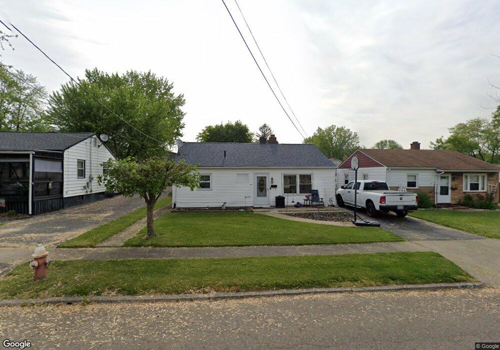
This home is located at 101 McDonald Ave, Niles, OH 44446 and is currently estimated at $101,763, approximately $99 per square foot. 101 McDonald Ave is a home located in Trumbull County with nearby schools including Niles Primary School, Niles Intermediate School, and Niles Middle School.
Ownership History
Date
Name
Owned For
Owner Type
Purchase Details
Closed on
Apr 24, 2007
Sold by
Ford Aaron P
Bought by
Ford Aaron P and Demare Kellie A
Current Estimated Value
Purchase Details
Closed on
Apr 11, 2007
Sold by
Ford Aaron P
Bought by
Ford Aaron P and Demare Kellie A
Purchase Details
Closed on
Oct 14, 2005
Sold by
Macali Renee M and Macali Palmer J
Bought by
Ford Aaron P
Home Financials for this Owner
Home Financials are based on the most recent Mortgage that was taken out on this home.
Original Mortgage
$54,255
Outstanding Balance
$33,410
Interest Rate
8.25%
Mortgage Type
Adjustable Rate Mortgage/ARM
Estimated Equity
$68,353
Purchase Details
Closed on
Oct 11, 2005
Sold by
Macali Renee M and Macali Palmer J
Bought by
Ford Aaron P
Home Financials for this Owner
Home Financials are based on the most recent Mortgage that was taken out on this home.
Original Mortgage
$54,255
Outstanding Balance
$33,410
Interest Rate
8.25%
Mortgage Type
Adjustable Rate Mortgage/ARM
Estimated Equity
$68,353
Purchase Details
Closed on
Jan 1, 1990
Sold by
Isenberg Sarah G
Bought by
Palmer J Macali
Create a Home Valuation Report for This Property
The Home Valuation Report is an in-depth analysis detailing your home's value as well as a comparison with similar homes in the area
Home Values in the Area
Average Home Value in this Area
Purchase History
| Date | Buyer | Sale Price | Title Company |
|---|---|---|---|
| Ford Aaron P | -- | None Available | |
| Ford Aaron P | -- | None Available | |
| Ford Aaron P | $54,255 | -- | |
| Ford Aaron P | $54,255 | -- | |
| Palmer J Macali | -- | -- |
Source: Public Records
Mortgage History
| Date | Status | Borrower | Loan Amount |
|---|---|---|---|
| Open | Ford Aaron P | $54,255 | |
| Closed | Ford Aaron P | $54,255 |
Source: Public Records
Tax History Compared to Growth
Tax History
| Year | Tax Paid | Tax Assessment Tax Assessment Total Assessment is a certain percentage of the fair market value that is determined by local assessors to be the total taxable value of land and additions on the property. | Land | Improvement |
|---|---|---|---|---|
| 2024 | $977 | $23,420 | $2,910 | $20,510 |
| 2023 | $977 | $23,420 | $2,910 | $20,510 |
| 2022 | $739 | $15,130 | $2,910 | $12,220 |
| 2021 | $776 | $15,130 | $2,910 | $12,220 |
| 2020 | $783 | $15,130 | $2,910 | $12,220 |
| 2019 | $762 | $14,010 | $2,910 | $11,100 |
| 2018 | $759 | $14,010 | $2,910 | $11,100 |
| 2017 | $755 | $14,010 | $2,910 | $11,100 |
| 2016 | $873 | $16,040 | $2,910 | $13,130 |
| 2015 | $863 | $16,040 | $2,910 | $13,130 |
| 2014 | $866 | $16,040 | $2,910 | $13,130 |
| 2013 | $864 | $16,880 | $2,910 | $13,970 |
Source: Public Records
Map
Nearby Homes
- 2003 James St
- 1804 Stepney St
- 1619 N Carnegie Ave
- 2213 N Glenwood Ave
- 1511 Kearney St
- 126 S Rhodes Ave
- 352 N Rhodes Ave
- 344 Mcevoy Ct
- 201 S Cleveland Ave
- 21 Summit Ave
- 2248 Crestmont Dr
- 1115 Estelle Ct
- 1863 Merlo Ct
- 0 Summit
- 2139 Coates Dr
- 2135 Isabelle Dr
- 207 Pennsylvania Ave
- 934 Mason St
- 219 Pennsylvania Ave
- 328 Scott Ave
- 43 McDonald Ave
- 39 McDonald Ave
- 111 McDonald Ave
- 50 Poplar Ave
- 54 Poplar Ave
- 44 Poplar Ave
- 60 Poplar Ave
- 38 Poplar Ave
- 110 McDonald Ave
- 119 McDonald Ave
- 29 McDonald Ave
- 34 Poplar Ave
- 34 McDonald Ave
- 118 McDonald Ave
- 25 McDonald Ave
- 1935 Stepney St
- 28 Poplar Ave
- 1942 Stepney St
- 124 McDonald Ave
- 45 Poplar Ave