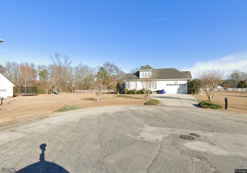
101 Meadowbrook Ct Benson, NC 27504
Estimated Value: $426,000 - $540,000
3
Beds
3
Baths
2,529
Sq Ft
$185/Sq Ft
Est. Value
About This Home
This home is located at 101 Meadowbrook Ct, Benson, NC 27504 and is currently estimated at $468,294, approximately $185 per square foot. 101 Meadowbrook Ct is a home located in Johnston County with nearby schools including Benson Elementary School, Benson Middle School, and South Johnston High School.
Ownership History
Date
Name
Owned For
Owner Type
Purchase Details
Closed on
Feb 22, 2011
Sold by
Younger Shane Edward
Bought by
Younger Andrew J and Younger Patricia A
Current Estimated Value
Home Financials for this Owner
Home Financials are based on the most recent Mortgage that was taken out on this home.
Original Mortgage
$237,305
Interest Rate
4.99%
Mortgage Type
New Conventional
Purchase Details
Closed on
Jan 20, 2011
Sold by
Younger Andrew J and Younger Patricia A
Bought by
Whittington Jack W
Home Financials for this Owner
Home Financials are based on the most recent Mortgage that was taken out on this home.
Original Mortgage
$237,305
Interest Rate
4.99%
Mortgage Type
New Conventional
Purchase Details
Closed on
Dec 10, 2010
Sold by
Shegog Patricia Ann
Bought by
Younger Andrew J and Younger Patricia A
Home Financials for this Owner
Home Financials are based on the most recent Mortgage that was taken out on this home.
Original Mortgage
$237,305
Interest Rate
4.99%
Mortgage Type
New Conventional
Purchase Details
Closed on
Dec 9, 2010
Sold by
Duffy Sonny James
Bought by
Younger Andrew J and Younger Patricia A
Home Financials for this Owner
Home Financials are based on the most recent Mortgage that was taken out on this home.
Original Mortgage
$237,305
Interest Rate
4.99%
Mortgage Type
New Conventional
Purchase Details
Closed on
Mar 29, 2010
Sold by
Younger Andrew J and Younger Patricia A
Bought by
Younger Andrew J and Younger Patricia A
Purchase Details
Closed on
Mar 24, 2010
Sold by
Younger Andrew J and Younger Patricia A
Bought by
Gilvin Ronnie Lynn and Duffy Sonny James
Purchase Details
Closed on
Nov 17, 2006
Sold by
Younger Andrew Jackson and Younger Patricia Ann Sills
Bought by
The Younger Family Revocable Marital Ded
Purchase Details
Closed on
Sep 15, 2005
Sold by
Rivenbark Robin Keith and Rivenbark Paula Ann
Bought by
Younger Andrew Jackson and Younger Patricia Ann Sills
Purchase Details
Closed on
May 31, 2002
Sold by
Rivenbark Robin Keith
Bought by
Junior Johnson Inc
Create a Home Valuation Report for This Property
The Home Valuation Report is an in-depth analysis detailing your home's value as well as a comparison with similar homes in the area
Home Values in the Area
Average Home Value in this Area
Purchase History
| Date | Buyer | Sale Price | Title Company |
|---|---|---|---|
| Younger Andrew J | -- | None Available | |
| Whittington Jack W | $230,000 | None Available | |
| Younger Andrew J | -- | None Available | |
| Younger Andrew J | -- | None Available | |
| Younger Andrew J | -- | None Available | |
| Younger Andrew J | -- | None Available | |
| Gilvin Ronnie Lynn | -- | None Available | |
| The Younger Family Revocable Marital Ded | -- | None Available | |
| Younger Andrew Jackson | $260,000 | None Available | |
| Junior Johnson Inc | $243,000 | -- |
Source: Public Records
Mortgage History
| Date | Status | Borrower | Loan Amount |
|---|---|---|---|
| Previous Owner | Whittington Jack W | $237,305 |
Source: Public Records
Tax History
| Year | Tax Paid | Tax Assessment Tax Assessment Total Assessment is a certain percentage of the fair market value that is determined by local assessors to be the total taxable value of land and additions on the property. | Land | Improvement |
|---|---|---|---|---|
| 2025 | $5,227 | $462,600 | $70,000 | $392,600 |
| 2024 | $3,466 | $270,790 | $32,000 | $238,790 |
| 2023 | $3,466 | $270,790 | $32,000 | $238,790 |
| 2022 | $3,466 | $270,790 | $32,000 | $238,790 |
| 2021 | $3,466 | $270,790 | $32,000 | $238,790 |
| 2020 | $3,493 | $270,790 | $32,000 | $238,790 |
| 2019 | $3,493 | $270,790 | $32,000 | $238,790 |
| 2018 | $3,534 | $267,740 | $45,000 | $222,740 |
| 2017 | $3,534 | $267,740 | $45,000 | $222,740 |
| 2016 | $3,507 | $267,740 | $45,000 | $222,740 |
| 2015 | $3,507 | $267,740 | $45,000 | $222,740 |
| 2014 | $3,507 | $267,740 | $45,000 | $222,740 |
Source: Public Records
Map
Nearby Homes
- 1039 N Lincoln St
- Tract 3 Benson Hardee Rd
- Tract 1 Benson Hardee Rd
- Tract 2 Benson Hardee Rd
- 0 Benson Hardee Rd Unit 10069689
- 704 N Lincoln St
- 140 Denning Farms Ln
- 503 N Lincoln St
- 240 Margot Manor Dr
- 401 N Lincoln St
- 1120 W Pope St
- 303 N Lincoln St
- 107 Oak Park Dr
- 702 W Main St
- 1343 Nc Hwy 27 W
- 245 Creek Crossing Dr
- 17 Geneva Cir
- 0 W Church St
- 302 S Pine St
- 413 S Plentiful Way Unit 107p
- 106 Meadowbrook Ct
- 106 Meadowbrook Ct Unit 15
- 112 Sunnybrook Cir
- 109 Sunnybrook Cir
- 109 Sunnybrook Cir Unit 7
- 113 Sunnybrook Cir
- 113 Sunnybrook Cir Unit 8
- 105 Meadowbrook Ct
- 105 Sunnybrook Cir
- 2222 N Carolina 50
- 83 Dogeye Rd
- 83 Dogeye Rd Unit 17
- 102 Sunnybrook Cir
- 2222 Nc Highway 50 N
- 2290 Nc Highway 50 N
- 99 Dogeye Rd
- 99 Dogeye Rd Unit 18
- 109 Meadowbrook Ct Unit 11
- 109 Meadowbrook Ct
- 110 Meadowbrook Ct
Your Personal Tour Guide
Ask me questions while you tour the home.