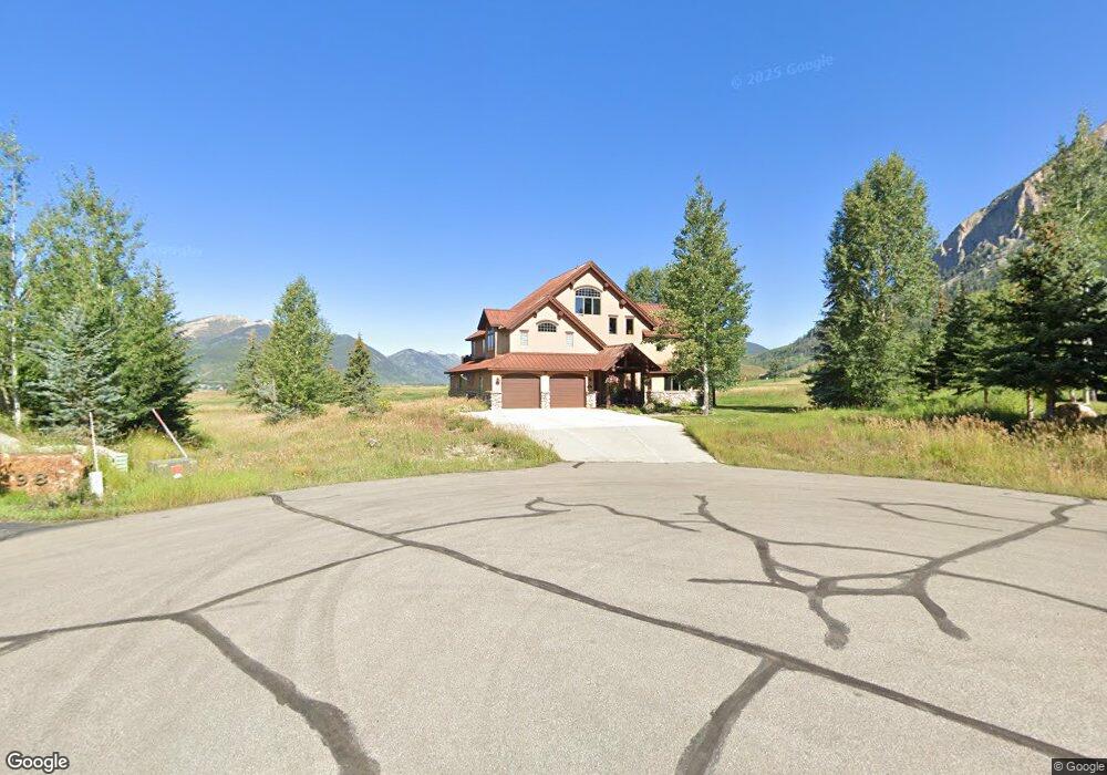
101 Mulligan Dr Crested Butte, CO 81224
Estimated Value: $3,357,933 - $4,574,000
4
Beds
4
Baths
3,776
Sq Ft
$1,008/Sq Ft
Est. Value
About This Home
This home is located at 101 Mulligan Dr, Crested Butte, CO 81224 and is currently estimated at $3,804,733, approximately $1,007 per square foot. 101 Mulligan Dr is a home located in Gunnison County with nearby schools including Gunnison Elementary School, Crested Butte Community School, and Gunnison Middle School.
Ownership History
Date
Name
Owned For
Owner Type
Purchase Details
Closed on
May 16, 2011
Sold by
Miner Race K and Miner Allison A
Bought by
Horne Paul T and Horne Shari T
Current Estimated Value
Home Financials for this Owner
Home Financials are based on the most recent Mortgage that was taken out on this home.
Original Mortgage
$937,500
Outstanding Balance
$642,440
Interest Rate
4.58%
Mortgage Type
Adjustable Rate Mortgage/ARM
Estimated Equity
$3,162,293
Purchase Details
Closed on
Dec 11, 2000
Sold by
Murry James M
Bought by
Miner Race K
Purchase Details
Closed on
Jul 7, 1997
Sold by
Murry
Bought by
Murry
Purchase Details
Closed on
Apr 30, 1997
Create a Home Valuation Report for This Property
The Home Valuation Report is an in-depth analysis detailing your home's value as well as a comparison with similar homes in the area
Home Values in the Area
Average Home Value in this Area
Purchase History
| Date | Buyer | Sale Price | Title Company |
|---|---|---|---|
| Horne Paul T | $1,250,000 | None Available | |
| Miner Race K | $1,275,000 | -- | |
| Murry | -- | -- | |
| -- | $160,000 | -- |
Source: Public Records
Mortgage History
| Date | Status | Borrower | Loan Amount |
|---|---|---|---|
| Open | Horne Paul T | $937,500 |
Source: Public Records
Tax History Compared to Growth
Tax History
| Year | Tax Paid | Tax Assessment Tax Assessment Total Assessment is a certain percentage of the fair market value that is determined by local assessors to be the total taxable value of land and additions on the property. | Land | Improvement |
|---|---|---|---|---|
| 2024 | $13,833 | $183,170 | $44,320 | $138,850 |
| 2023 | $13,696 | $179,490 | $43,430 | $136,060 |
| 2022 | $11,915 | $133,450 | $23,280 | $110,170 |
| 2021 | $10,968 | $137,290 | $23,950 | $113,340 |
| 2020 | $7,509 | $89,200 | $20,110 | $69,090 |
| 2019 | $7,405 | $89,200 | $20,110 | $69,090 |
| 2018 | $7,553 | $83,960 | $17,500 | $66,460 |
| 2017 | $7,602 | $83,960 | $17,500 | $66,460 |
| 2016 | $7,531 | $86,620 | $19,900 | $66,720 |
Source: Public Records
Map
Nearby Homes
- 402 Eagle Ln
- 262 Larkspur Loop
- 166 & 168 Coyote Cir
- 315 Par Ln
- 115 Larkspur Loop
- 365 Larkspur Loop
- 140 Alpine Ct
- 429 Larkspur Loop
- 17 Short Dr
- 350 Country Club Dr Unit 217A
- 350 Country Club Dr Unit 218A
- 350 Country Club Dr Unit 402A
- 64 Vista Ct
- 22 Links Ln
- 412 Ridge Rd
- 491 Slate River Dr
- 88 Vista Ct
- 288 Forest Ln
- 434 Country Club Dr
- 179 Aspen Ln
- 1 Mulligan Dr
- 81 Mulligan Dr
- 98 Mulligan Dr
- 86 Mulligan Dr
- 68 Mulligan Dr
- 53 Mulligan Dr
- 233 Fairway Dr
- 40 Mulligan Dr
- 0 Mulligan Dr
- 249 Fairway Dr
- 217 Fairway Dr
- 217 Fairway Dr Unit LOT S92 SKYLAND INIT
- 29 Mulligan Dr
- 0 Fairway Dr Unit 766554
- 0 Fairway Dr Unit 762047
- 0 Fairway Dr Unit 761514
- 0 Fairway Dr Unit 760908
- 0 Fairway Dr Unit 758336
- 0 Fairway Dr Unit 757055
- 0 Fairway Dr Unit 742510