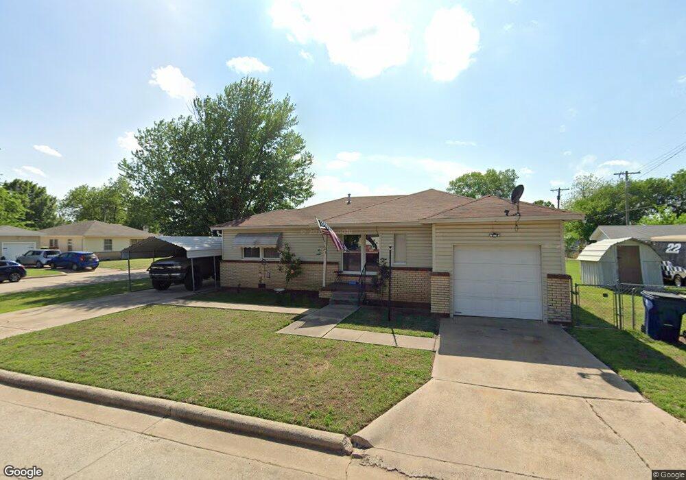
101 N 21st St Duncan, OK 73533
Estimated Value: $63,509 - $85,000
3
Beds
2
Baths
986
Sq Ft
$77/Sq Ft
Est. Value
About This Home
This home is located at 101 N 21st St, Duncan, OK 73533 and is currently estimated at $76,377, approximately $77 per square foot. 101 N 21st St is a home located in Stephens County with nearby schools including Mark Twain Elementary School, Duncan Middle School, and Duncan High School.
Ownership History
Date
Name
Owned For
Owner Type
Purchase Details
Closed on
Oct 18, 2016
Sold by
Mccasland Ellen
Bought by
Ace Properties Llc
Current Estimated Value
Purchase Details
Closed on
Jun 21, 2016
Sold by
Mccosland Lorrain N
Bought by
Mccosland Ellen
Purchase Details
Closed on
Oct 1, 2009
Sold by
Hennan Bradley and Hennan Rhonda
Bought by
Mccasland Lorrian N and Mccasland Dorothy M
Purchase Details
Closed on
Feb 5, 2003
Sold by
Huff William D and Huff Atricia
Purchase Details
Closed on
Jun 20, 2001
Sold by
Knight Tammy
Purchase Details
Closed on
Jun 2, 1995
Sold by
Huff William D
Purchase Details
Closed on
Apr 8, 1994
Sold by
Johnson Norma Jean
Purchase Details
Closed on
Nov 10, 1992
Sold by
Worrell Glen E
Create a Home Valuation Report for This Property
The Home Valuation Report is an in-depth analysis detailing your home's value as well as a comparison with similar homes in the area
Home Values in the Area
Average Home Value in this Area
Purchase History
| Date | Buyer | Sale Price | Title Company |
|---|---|---|---|
| Ace Properties Llc | -- | None Available | |
| Mccosland Ellen | -- | None Available | |
| Mccasland Lorrian N | $40,000 | None Available | |
| -- | $31,500 | -- | |
| -- | $27,500 | -- | |
| -- | $18,500 | -- | |
| -- | $16,000 | -- | |
| -- | $14,500 | -- |
Source: Public Records
Tax History Compared to Growth
Tax History
| Year | Tax Paid | Tax Assessment Tax Assessment Total Assessment is a certain percentage of the fair market value that is determined by local assessors to be the total taxable value of land and additions on the property. | Land | Improvement |
|---|---|---|---|---|
| 2025 | $372 | $4,581 | $507 | $4,074 |
| 2024 | $372 | $4,363 | $507 | $3,856 |
| 2023 | $372 | $4,155 | $507 | $3,648 |
| 2022 | $345 | $4,092 | $507 | $3,585 |
| 2021 | $328 | $3,859 | $507 | $3,352 |
| 2020 | $350 | $4,055 | $507 | $3,548 |
| 2019 | $334 | $3,862 | $507 | $3,355 |
| 2018 | $328 | $3,683 | $507 | $3,176 |
| 2017 | $301 | $3,503 | $507 | $2,996 |
| 2016 | $421 | $4,953 | $507 | $4,446 |
| 2015 | $404 | $4,717 | $507 | $4,210 |
| 2014 | $404 | $4,492 | $550 | $3,942 |
Source: Public Records
Map
Nearby Homes
- 2006 W Oak Ave
- 2011 2011 W Oak Ave
- 2108 Ave
- 174831 N 2844 Rd
- 210 N 22nd St
- 1812 W Walnut Ave
- 2110 W Main St
- 209 N 22nd St
- 201 N 23rd St
- 106 Emery Rd
- 2210 Western Dr
- 206 N 28th St
- 507 N Alice Dr
- 27 N 14th St
- 0 W Beech Ave
- 210 210 N 31st St
- 2206 2206 W Spruce
- 2230 W Spruce St
- 1203 W Walnut Ave
- 1309 W Pecan Ave
- 2103 W Birch Ave
- 2011 W Birch Ave
- 2102 W Oak Ave
- 2105 W Birch Ave
- 2102 W Birch Ave
- 2104 W Oak Ave
- 2102 W Birch Ave
- 2012 W Oak Ave
- 2106 W Oak Ave
- 2104 W Birch Ave
- 2009 W Birch Ave
- 2009 W Birch Ave
- 2107 W Birch Ave
- 2012 W Birch Ave
- 2106 W Birch Ave
- 2010 W Oak Ave
- 2108 W Oak Ave
- 2108 W Birch Ave
- 2010 W Birch Ave
- 2109 W Birch Ave