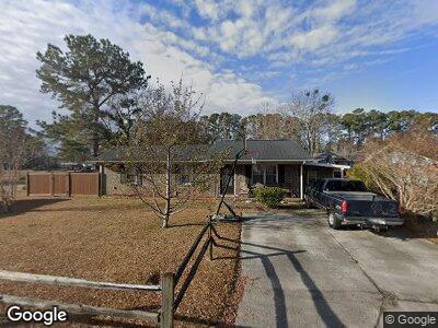
101 Neal Ln Myrtle Beach, SC 29588
Estimated Value: $1,498,000 - $2,134,000
4
Beds
4
Baths
4,133
Sq Ft
$409/Sq Ft
Est. Value
About This Home
This home is located at 101 Neal Ln, Myrtle Beach, SC 29588 and is currently estimated at $1,689,048, approximately $408 per square foot. 101 Neal Ln is a home located in Horry County with nearby schools including Socastee Elementary School, Forestbrook Middle School, and Socastee High School.
Ownership History
Date
Name
Owned For
Owner Type
Purchase Details
Closed on
Apr 7, 2025
Sold by
Desalvo Matthew James
Bought by
Desalvo Matthew J and Desalvo Debby T
Current Estimated Value
Purchase Details
Closed on
Jun 11, 2018
Sold by
Coleman
Bought by
Desalvo Matthew J and Desalvo Debby T
Purchase Details
Closed on
Sep 30, 2015
Bought by
Coleman Family
Purchase Details
Closed on
Dec 9, 2014
Sold by
Coleman James R
Bought by
Coleman Lindsay B
Purchase Details
Closed on
Jun 19, 2013
Sold by
King Anthony B
Bought by
Coleman Lindsay B
Purchase Details
Closed on
Jul 30, 1998
Sold by
Roane Gales P
Bought by
King Anthony B and King Winnie B
Create a Home Valuation Report for This Property
The Home Valuation Report is an in-depth analysis detailing your home's value as well as a comparison with similar homes in the area
Home Values in the Area
Average Home Value in this Area
Purchase History
| Date | Buyer | Sale Price | Title Company |
|---|---|---|---|
| Desalvo Matthew J | -- | -- | |
| Desalvo Matthew J | $755,000 | -- | |
| Coleman Family | -- | -- | |
| Coleman Lindsay B | -- | -- | |
| Coleman Lindsay B | $665,000 | -- | |
| King Anthony B | $430,000 | -- |
Source: Public Records
Mortgage History
| Date | Status | Borrower | Loan Amount |
|---|---|---|---|
| Previous Owner | King Anthony B | $200,000 |
Source: Public Records
Tax History Compared to Growth
Tax History
| Year | Tax Paid | Tax Assessment Tax Assessment Total Assessment is a certain percentage of the fair market value that is determined by local assessors to be the total taxable value of land and additions on the property. | Land | Improvement |
|---|---|---|---|---|
| 2024 | $4,185 | $40,788 | $11,608 | $29,180 |
| 2023 | $4,185 | $40,788 | $11,608 | $29,180 |
| 2021 | $3,757 | $61,182 | $17,412 | $43,770 |
| 2020 | $3,247 | $61,182 | $17,412 | $43,770 |
| 2019 | $11,810 | $45,828 | $17,412 | $28,416 |
| 2018 | $2,091 | $39,897 | $15,051 | $24,846 |
| 2017 | $2,032 | $39,897 | $15,051 | $24,846 |
| 2016 | -- | $39,897 | $15,051 | $24,846 |
| 2015 | $2,014 | $39,897 | $15,051 | $24,846 |
| 2014 | $1,458 | $32,067 | $15,051 | $17,016 |
Source: Public Records
Map
Nearby Homes
- 113 Neal Ln
- 3456 Macklen Rd Unit 18B
- 330 Fairwood Terrace
- 103 Ebb Tide Harbour Unit HARBOUR TOWN
- 1310 Hidden Harbor Rd
- 1336 Winding Creek Way
- 1255 Winding Creek Way Unit Phase 1 lot 53
- 1240 Winding Creek Way Unit Phase 1 lot 104
- 543 Oak Landing Dr Unit Phase 1 lot 127
- 5535 Creon St Unit MB
- 531 Oak Landing Dr Unit Phase 1 lot 124
- 220 River Edge Dr Unit Phase 1 lot 11
- 527 Oak Landing Dr
- 1437 Shoreline Dr
- 523 Oak Landing Dr Unit Phase 1 lot 122
- 224 River Edge Dr Unit Phase 1 lot 10
- 515 Oak Landing Dr Unit Phase 1 lot 120
- 3020 River Island Way Unit Phase 3 lot 384
- 232 River Edge Dr Unit Phase 1 lot 8
- 202 Millstone Dr
- 101 Neal Ln
- 101 Neal Ln
- 103 Neal Ln
- 177 Ranchette Cir
- 173 Ranchette Cir
- 100 Neal Ln
- 105 Neal Ln
- 105 Neal Ln
- 93 Ranchette Cir
- 102 Neal Ln
- 171 Ranchette Cir
- 209 Ranchette Cir Unit A
- 209 Ranchette Cir
- 209B Ranchette Cir Unit B
- 209 Ranchette Cir Unit B
- 209 Ranchette Cir Unit B
- 213 Ranchette Cir Unit s 213AB - 215AB
- 215 Ranchette Cir
- 213 Ranchette Cir
- 169 Ranchette Cir