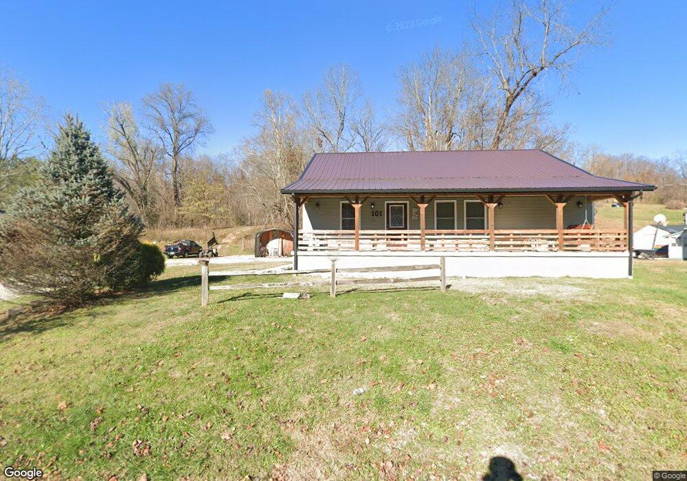
101 Patrick St Coal Grove, OH 45638
Estimated Value: $141,000 - $250,000
2
Beds
2
Baths
1,424
Sq Ft
$127/Sq Ft
Est. Value
About This Home
This home is located at 101 Patrick St, Coal Grove, OH 45638 and is currently estimated at $181,291, approximately $127 per square foot. 101 Patrick St is a home located in Lawrence County with nearby schools including Dawson-Bryant Elementary School, Dawson-Bryant Middle School, and Dawson-Bryant High School.
Ownership History
Date
Name
Owned For
Owner Type
Purchase Details
Closed on
Sep 2, 2014
Sold by
Moore Shellie D and Moore 2 Floyd E
Bought by
Mcgovern Clara
Current Estimated Value
Purchase Details
Closed on
Oct 19, 2007
Sold by
Sites Shellie
Bought by
Sites Shellie and Moore Ii Floyd E
Purchase Details
Closed on
Jun 2, 1994
Sold by
Spurlock Louise
Bought by
Sites Stephen and Sites Shellie
Purchase Details
Closed on
Nov 5, 1992
Sold by
Spurlock Homer T and Spurlock Loui
Bought by
Spurlock Louise
Create a Home Valuation Report for This Property
The Home Valuation Report is an in-depth analysis detailing your home's value as well as a comparison with similar homes in the area
Home Values in the Area
Average Home Value in this Area
Purchase History
| Date | Buyer | Sale Price | Title Company |
|---|---|---|---|
| Mcgovern Clara | $25,000 | -- | |
| Sites Shellie | $12,915 | Attorney | |
| Sites Stephen | $15,000 | -- | |
| Spurlock Louise | -- | -- |
Source: Public Records
Tax History
| Year | Tax Paid | Tax Assessment Tax Assessment Total Assessment is a certain percentage of the fair market value that is determined by local assessors to be the total taxable value of land and additions on the property. | Land | Improvement |
|---|---|---|---|---|
| 2025 | $1,558 | $55,328 | $3,997 | $51,331 |
| 2024 | $1,558 | $50,300 | $3,630 | $46,670 |
| 2023 | $1,557 | $50,300 | $3,630 | $46,670 |
| 2022 | $1,554 | $50,300 | $3,630 | $46,670 |
| 2021 | $1,428 | $46,900 | $3,460 | $43,440 |
| 2020 | $1,490 | $46,900 | $3,460 | $43,440 |
| 2019 | $1,485 | $46,900 | $3,460 | $43,440 |
| 2018 | $397 | $10,900 | $3,460 | $7,440 |
| 2017 | $396 | $10,900 | $3,460 | $7,440 |
| 2016 | $369 | $10,900 | $3,460 | $7,440 |
| 2015 | $361 | $9,840 | $3,460 | $6,380 |
| 2014 | $338 | $9,840 | $3,460 | $6,380 |
| 2013 | $337 | $9,840 | $3,460 | $6,380 |
Source: Public Records
Map
Nearby Homes
- 103 Carrico Dr
- 1003 Marion Pike
- 519 Lane St
- 514 Lane St
- 303 Pike St
- 37 Township Road 268
- 0 Central & Mlk
- 1824 Carter Ave
- 508 16th St
- 0 18th Street & Central Ave
- 1400 Montgomery Ave
- 0 Central Ave
- 2805 S 8th St
- 2721 S 8th St
- 2620 S 13th St
- 148 Private Road 707
- 2725 S 5th St
- 321 Wyanoke St
- 2601 S 6th St
- 000 Chestnut Hill Dr
- 827 Marion Pike
- 105 Patrick St
- 845 Marion Pike
- 900 Marion Pike
- 909 Marion Pike
- 102 Remy St
- 908 Marion Pike
- 911 Marion Pike
- 111 Patrick St
- 898 Marion Pike
- 849 Marion Pike
- 104 Remy St
- 113 Patrick St
- 856 Marion Pike
- 913 Marion Pike
- 910 Marion Pike
- 914 Marion Pike
- 841 Marion Pike
- 854 Marion Pike Unit JO-3
- 854 Marion Pike Unit OJ-3
Your Personal Tour Guide
Ask me questions while you tour the home.