
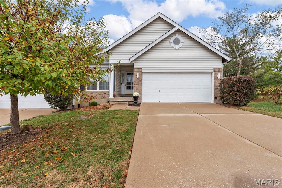

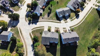
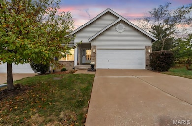
101 Robbins Way Dr Florissant, MO 63034
Estimated payment $1,946/month
Total Views
31,928
2
Beds
3
Baths
2,720
Sq Ft
$106
Price per Sq Ft
Highlights
- Hot Property
- Recreation Room
- Traditional Architecture
- Deck
- Vaulted Ceiling
- Walk-In Pantry
About This Home
Welcome to 101 Robbins Way Drive—where comfort meets connection, and every corner whispers “you’re home.”
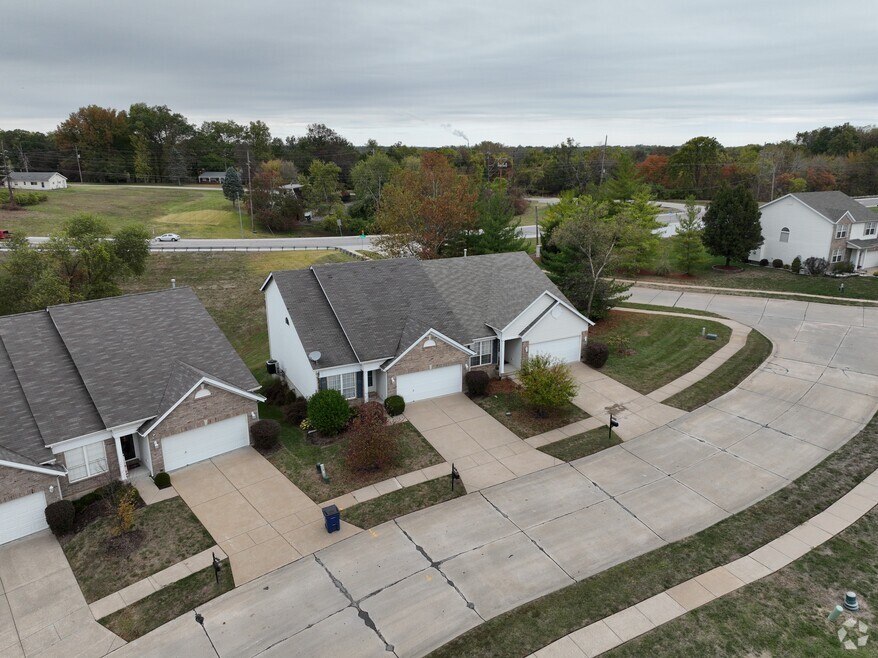
Step into a sunlit sanctuary nestled in the heart of Florissant. This 2-bedroom, 3-bath retreat doesn’t just offer space—it offers serenity. From the moment you enter, the living room greets you like an old friend, and the dedicated office/ formal dining space invites your dreams to take root. Whether building your empire from home or entertaining during the holidays if you prefer a formal dining room. The kitchen is more than functional—it’s a place to gather, to laugh, to linger. Luxury vinyl plank floors guide you to a breakfast room wrapped in bay windows, where morning light dances across your coffee cup and the deck beckons you to breathe in the day. The primary suite is a haven of harmony, with dual vanities and his-and-hers closets that honor both individuality and togetherness. And downstairs? A finished walk-out lower level with its own full bath—perfect for guests, creativity, or quiet reflection. Your wish is easy in this lower level, create your home theater or gym and include a family room and recreation space. Outside, the Robbins Mill Estates community offers peace of mind with maintained grounds and snow removal, so you can focus on what matters: living fully, loving deeply, and building your next chapter. This isn’t just a house. It’s a feeling. A rhythm. A place where your story unfolds.
Property Details
Home Type
- Multi-Family
Est. Annual Taxes
- $2,741
Year Built
- Built in 2001
Lot Details
- 8,276 Sq Ft Lot
- Lot Dimensions are 65 x 128
- Level Lot
HOA Fees
- $195 Monthly HOA Fees
Parking
- 2 Car Attached Garage
- Parking Deck
- Front Facing Garage
Home Design
- Traditional Architecture
- Villa
- Property Attached
- Brick Veneer
- Vinyl Siding
- Concrete Perimeter Foundation
Interior Spaces
- 1-Story Property
- Vaulted Ceiling
- Gas Log Fireplace
- Sliding Doors
- Panel Doors
- Entrance Foyer
- Living Room with Fireplace
- Dining Room
- Recreation Room
- Bonus Room
- Utility Room
- Basement
Kitchen
- Eat-In Kitchen
- Walk-In Pantry
- Electric Oven
- Built-In Electric Range
- Microwave
- Dishwasher
- Stainless Steel Appliances
Flooring
- Carpet
- Luxury Vinyl Plank Tile
- Luxury Vinyl Tile
Bedrooms and Bathrooms
- 2 Bedrooms
- Double Vanity
Laundry
- Laundry Room
- Laundry on main level
- Dryer
- Washer
Outdoor Features
- Deck
- Patio
- Front Porch
Schools
- Barrington Elem. Elementary School
- Central Middle School
- Hazelwood Central High School
Utilities
- Forced Air Heating and Cooling System
- Natural Gas Connected
- Gas Water Heater
- Cable TV Available
Listing and Financial Details
- Home warranty included in the sale of the property
- Assessor Parcel Number 06G-23-0240
Community Details
Overview
- Association fees include ground maintenance, maintenance parking/roads, common area maintenance, snow removal
- Robbins Mill Estates Association
Amenities
- Common Area
3D Interior and Exterior Tours
Floorplans
Map
Create a Home Valuation Report for This Property
The Home Valuation Report is an in-depth analysis detailing your home's value as well as a comparison with similar homes in the area
Home Values in the Area
Average Home Value in this Area
Tax History
| Year | Tax Paid | Tax Assessment Tax Assessment Total Assessment is a certain percentage of the fair market value that is determined by local assessors to be the total taxable value of land and additions on the property. | Land | Improvement |
|---|---|---|---|---|
| 2025 | $2,741 | $38,530 | $4,200 | $34,330 |
| 2024 | $2,741 | $30,080 | $2,550 | $27,530 |
| 2023 | $2,731 | $30,080 | $2,550 | $27,530 |
| 2022 | $2,628 | $25,740 | $5,470 | $20,270 |
| 2021 | $2,487 | $25,740 | $5,470 | $20,270 |
| 2020 | $2,288 | $22,030 | $2,190 | $19,840 |
| 2019 | $2,251 | $22,030 | $2,190 | $19,840 |
| 2018 | $2,214 | $20,030 | $1,540 | $18,490 |
| 2017 | $2,211 | $20,030 | $1,540 | $18,490 |
| 2016 | $2,337 | $20,840 | $1,880 | $18,960 |
| 2015 | $2,284 | $20,840 | $1,880 | $18,960 |
| 2014 | $2,383 | $21,660 | $5,430 | $16,230 |
Source: Public Records
Property History
| Date | Event | Price | List to Sale | Price per Sq Ft |
|---|---|---|---|---|
| 11/03/2025 11/03/25 | Price Changed | $289,000 | -3.3% | $106 / Sq Ft |
| 11/03/2025 11/03/25 | For Sale | $299,000 | -- | $110 / Sq Ft |
Source: MARIS MLS
Purchase History
| Date | Type | Sale Price | Title Company |
|---|---|---|---|
| Quit Claim Deed | -- | None Listed On Document | |
| Warranty Deed | $160,000 | -- |
Source: Public Records
Mortgage History
| Date | Status | Loan Amount | Loan Type |
|---|---|---|---|
| Previous Owner | $131,600 | No Value Available |
Source: Public Records
About the Listing Agent
I'm an expert real estate agent with Keller Williams Realty Chesterfield in Florissant, MO, St. Louis and St Charles counties, providing home-buyers and sellers with professional, responsive, and attentive real estate services. Want an agent who'll really listen to what you want in a home? Need an agent who knows how to effectively market your home so it sells? I will help you develop and execute your unique strategy! I work hard to meet or exceed your goal! Give me a call! I'm eager to help
Rhonda's Other Listings
Source: MARIS MLS
MLS Number: MIS25071468
APN: 06G-23-0240
Disclaimer: Certain information contained herein is derived from information provided by parties other than Homes.com. All information provided is deemed reliable, but is not guaranteed to be accurate and should be independently verified.
![]() Based on information submitted to the MLS GRID. All data is obtained from various sources and may not have been verified by broker or MLS GRID. Supplied Open House Information is subject to change without notice. All information should be independently reviewed and verified for accuracy. Properties may or may not be listed by the office/agent presenting the information. Some IDX listings have been excluded from this website.
Based on information submitted to the MLS GRID. All data is obtained from various sources and may not have been verified by broker or MLS GRID. Supplied Open House Information is subject to change without notice. All information should be independently reviewed and verified for accuracy. Properties may or may not be listed by the office/agent presenting the information. Some IDX listings have been excluded from this website.
The Digital Millennium Copyright Act of 1998, 17 U.S.C. § 512 (the “DMCA”) provides recourse for copyright owners who believe that material appearing on the Internet infringes their rights under U.S. copyright law. If you believe in good faith that any content or material made available in connection with our website or services infringes your copyright, you (or your agent) may send us a notice requesting that the content or material be removed, or access to it blocked.
Notices must be sent in writing by email to DMCAnotice@MLSGrid.com.
The DMCA requires that your notice of alleged copyright infringement include the following information:
(1) description of the copyrighted work that is the subject of claimed infringement;
(2) description of the alleged infringing content and information sufficient to permit us to locate the content;
(3) contact information for you, including your address, telephone number and email address;
(4) a statement by you that you have a good faith belief that the content in the manner complained of is not authorized by the copyright owner, or its agent, or by the operation of any law;
(5) a statement by you, signed under penalty of perjury, that the information in the notification is accurate and that you have the authority to enforce the copyrights that are claimed to be infringed; and
(6) a physical or electronic signature of the copyright owner or a person authorized to act on the copyright owner’s behalf. Failure to include all of the above information may result in the delay of the processing of your complaint.
Nearby Homes
- 144 Carytown Ln
- 210 Behlmann Meadows Way
- 4308 Hollow Brook Ct
- 4681 Richmond Forest Dr
- 14333 River Oaks Ct
- 4304 Inlet Isle Dr Unit 7
- 4328 Inlet Isle Dr
- 13630 Old Halls Ferry Rd
- 14214 Ashbury Meadows Dr
- 14234 Ashbury Meadows Dr
- 14428 Williamsburg Manor Dr
- 4373 Old Jamestown Winery Rd
- 13124 Crestwood Bend Ln
- 5618 Madlar Ln
- 5625 Delcastle Dr
- 13125 Crestwood Bend Ln
- 13136 Crestwood Bend Ln
- 13140 Crestwood Bend Ln
- 13141 Crestwood Bend Ln
- 13107 Ambrose Ct
- 14368 Jamestown Bay Dr
- 14429 Jamestown Bay Dr
- 5707 Hidden Cove Ln
- 13054 Mystic Bend Ln
- 3665 Seville Dr
- 3665 Hambletonian Dr
- 3144 Sunswept Park Dr
- 3209 Cross Keys Dr
- 3748 Riviere Marne Ct
- 2990 Santiago Dr
- 2701 Wintergreen Dr
- 15623 92nd Ave
- 4583 Whisper Lake Dr
- 5354 Trailview Dr
- 3935 Parker Rd
- 4031 Les Cherbourg Ln
- 1670 Fairmount Dr
- 2510 Woodsage Dr
- 3115 Wellington Dr
- 4158 Fox Crossing Dr