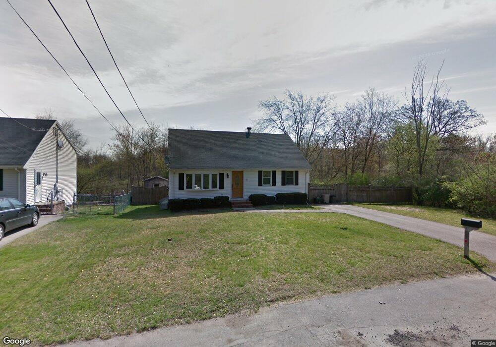
101 Stockholm Ave Brockton, MA 02301
Campello NeighborhoodEstimated Value: $503,000 - $547,000
3
Beds
1
Bath
1,411
Sq Ft
$373/Sq Ft
Est. Value
About This Home
This home is located at 101 Stockholm Ave, Brockton, MA 02301 and is currently estimated at $526,353, approximately $373 per square foot. 101 Stockholm Ave is a home located in Plymouth County with nearby schools including Davis K-8 School, John F. Kennedy Elementary School, and South Middle School.
Ownership History
Date
Name
Owned For
Owner Type
Purchase Details
Closed on
Jun 3, 1998
Sold by
Johnson Robert D
Bought by
Waugh Linda D
Current Estimated Value
Purchase Details
Closed on
Nov 22, 1995
Sold by
Dias Peter A and Dias Mary J
Bought by
Johnson Robert D
Purchase Details
Closed on
May 19, 1993
Sold by
Eldan Constr Co Inc
Bought by
Dias Peter A and Dias Mary J
Create a Home Valuation Report for This Property
The Home Valuation Report is an in-depth analysis detailing your home's value as well as a comparison with similar homes in the area
Home Values in the Area
Average Home Value in this Area
Purchase History
| Date | Buyer | Sale Price | Title Company |
|---|---|---|---|
| Waugh Linda D | $118,900 | -- | |
| Johnson Robert D | $103,500 | -- | |
| Dias Peter A | $99,900 | -- |
Source: Public Records
Mortgage History
| Date | Status | Borrower | Loan Amount |
|---|---|---|---|
| Open | Dias Peter A | $60,000 | |
| Open | Dias Peter A | $150,000 |
Source: Public Records
Tax History Compared to Growth
Tax History
| Year | Tax Paid | Tax Assessment Tax Assessment Total Assessment is a certain percentage of the fair market value that is determined by local assessors to be the total taxable value of land and additions on the property. | Land | Improvement |
|---|---|---|---|---|
| 2025 | $5,321 | $439,400 | $185,700 | $253,700 |
| 2024 | $5,015 | $417,200 | $185,700 | $231,500 |
| 2023 | $4,949 | $381,300 | $140,000 | $241,300 |
| 2022 | $4,996 | $357,600 | $127,300 | $230,300 |
| 2021 | $4,347 | $299,800 | $109,500 | $190,300 |
| 2020 | $4,453 | $293,900 | $95,500 | $198,400 |
| 2019 | $4,140 | $266,400 | $90,900 | $175,500 |
| 2018 | $3,965 | $246,900 | $90,900 | $156,000 |
| 2017 | $3,780 | $234,800 | $90,900 | $143,900 |
| 2016 | $3,762 | $216,700 | $87,500 | $129,200 |
| 2015 | $3,512 | $193,500 | $87,500 | $106,000 |
| 2014 | $3,564 | $196,600 | $87,500 | $109,100 |
Source: Public Records
Map
Nearby Homes
- 358 Copeland St
- 15 Longworth Ave Unit 231
- 35 Longworth Ave Unit 17
- 13 Finny's Way
- 15 Fieldstone Dr
- 1 Fairway Dr
- 47 Southworth St
- 163 S Leyden St
- 21 Roosevelt Ave
- 115 Market St
- 16 Friendship Dr
- 223 Clinton St Unit 10
- 223 Clinton St Unit 3
- 65 Tremont St
- 18 American Ave
- 977 Warren Ave
- 137 Channing Ave
- 122 Sinclair Rd
- 139 Geralynn Dr
- 1036 Ash St
- 111 Stockholm Ave
- 95 Hubbard Ave
- 85 Hubbard Ave
- 115 Hubbard Ave
- 92 Hubbard Ave
- 125 Hubbard Ave
- 86 Hubbard Ave
- 104 Hubbard Ave
- 82 Hubbard Ave
- 110 Hubbard Ave
- 47 Glendale Ave
- 126 Hubbard Ave
- 57 Glendale Ave
- 35 Glendale Ave
- 133 Hubbard Ave
- 63 Glendale Ave
- 130 Hubbard Ave
- 67 Glendale Ave
- 55 Lawson Terrace
- 71 Glendale Ave