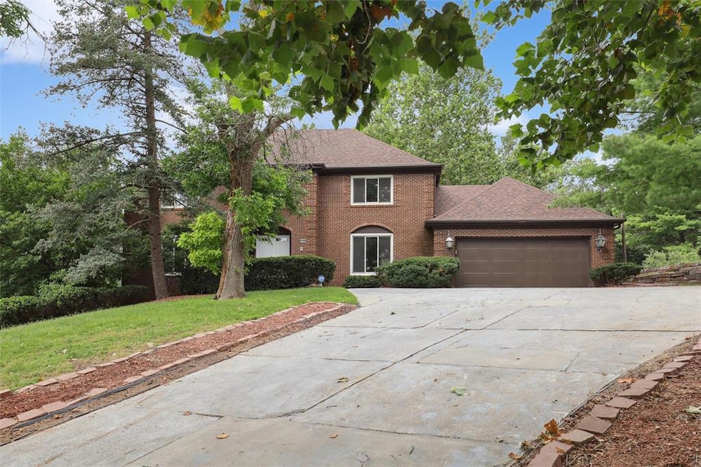


1010 56th St Des Moines, IA 50311
Waveland Woods NeighborhoodEstimated payment $4,457/month
Highlights
- 0.48 Acre Lot
- Recreation Room
- Sun or Florida Room
- Deck
- 2 Fireplaces
- No HOA
About This Home
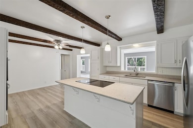
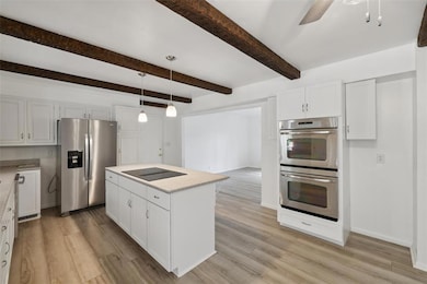
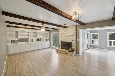
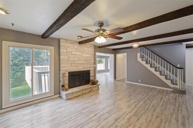
This home blends new & old for a unique flair! So much to see and enjoy inside and out! Gracious front entry. Large white kitchen with granite counters, & SS appliances including built in double oven. All rooms are oversized & include formal dining, living room with stone fireplace, built-ins & ceiling beams, flex room perfect for office or play area, guest bath, & don’t forget the massive 4 season room (addition 2020) overlooking the deck and backyard! This home boast 5 bedrooms all on the 2nd floor including the owner suite with 3⁄4 Bath and walk in closet. Generous sized bedrooms, full bath and laundry complete this floor. Head down to the lower level to enjoy sitting by the fireplace or move into the entertainment room complete with retro stone wet bar & lime green stools! Rooms that make perfect recreation or storage space, and a second 4 season room that walks out to patio. 2 car garage is oversized, and service door walks out to covered area that has additional attached outdoor storage entry space. Home sits on almost half acre and has an irrigation system, Newer Anderson Windows to boot! Located in Waveland Woods, you have Views of the Waveland golf course & quick access to almost anywhere you are headed around town!
Home Details
Home Type
- Single Family
Est. Annual Taxes
- $12,284
Year Built
- Built in 1969
Lot Details
- 0.48 Acre Lot
- Lot Dimensions are 100x210
- Irrigation
Home Design
- Brick Exterior Construction
- Asphalt Shingled Roof
- Vinyl Siding
Interior Spaces
- 3,218 Sq Ft Home
- 2-Story Property
- Wet Bar
- 2 Fireplaces
- Family Room Downstairs
- Formal Dining Room
- Den
- Recreation Room
- Sun or Florida Room
Kitchen
- Eat-In Kitchen
- Built-In Double Oven
- Cooktop
- Dishwasher
Flooring
- Carpet
- Luxury Vinyl Plank Tile
Bedrooms and Bathrooms
- 5 Bedrooms
Laundry
- Laundry on upper level
- Dryer
- Washer
Finished Basement
- Walk-Out Basement
- Natural lighting in basement
Parking
- 2 Car Attached Garage
- Driveway
Outdoor Features
- Deck
- Covered Patio or Porch
Utilities
- Forced Air Heating and Cooling System
Community Details
- No Home Owners Association
Listing and Financial Details
- Assessor Parcel Number 09007113000000
Map
Home Values in the Area
Average Home Value in this Area
Tax History
| Year | Tax Paid | Tax Assessment Tax Assessment Total Assessment is a certain percentage of the fair market value that is determined by local assessors to be the total taxable value of land and additions on the property. | Land | Improvement |
|---|---|---|---|---|
| 2025 | $12,032 | $791,400 | $63,000 | $728,400 |
| 2024 | $12,032 | $622,100 | $55,600 | $566,500 |
| 2023 | $11,370 | $710,600 | $55,600 | $655,000 |
| 2022 | $11,282 | $579,800 | $47,800 | $532,000 |
| 2021 | $11,004 | $579,800 | $47,800 | $532,000 |
| 2020 | $11,428 | $538,100 | $44,300 | $493,800 |
| 2019 | $11,026 | $449,600 | $44,300 | $405,300 |
| 2018 | $10,820 | $418,800 | $39,300 | $379,500 |
| 2017 | $9,580 | $418,800 | $39,300 | $379,500 |
| 2016 | $9,328 | $366,000 | $34,200 | $331,800 |
| 2015 | $9,328 | $366,000 | $34,200 | $331,800 |
| 2014 | $8,634 | $337,000 | $30,800 | $306,200 |
Property History
| Date | Event | Price | List to Sale | Price per Sq Ft |
|---|---|---|---|---|
| 09/18/2025 09/18/25 | Price Changed | $650,000 | -2.3% | $202 / Sq Ft |
| 08/19/2025 08/19/25 | For Sale | $665,000 | -- | $207 / Sq Ft |
Purchase History
| Date | Type | Sale Price | Title Company |
|---|---|---|---|
| Interfamily Deed Transfer | -- | None Available |
Mortgage History
| Date | Status | Loan Amount | Loan Type |
|---|---|---|---|
| Closed | $274,160 | New Conventional |
Source: Des Moines Area Association of REALTORS®
MLS Number: 724553
APN: 090-07113000000
Disclaimer: Certain information contained herein is derived from information provided by parties other than Homes.com. All information provided is deemed reliable, but is not guaranteed to be accurate and should be independently verified.
![]() IDX information is provided exclusively for personal, non-commercial use, and may not be used for any purpose other than to identify prospective properties consumers may be interested in purchasing. Information is deemed reliable but not guaranteed.
IDX information is provided exclusively for personal, non-commercial use, and may not be used for any purpose other than to identify prospective properties consumers may be interested in purchasing. Information is deemed reliable but not guaranteed.
- 1051 57th St
- 1129 57th St
- 5610 University Ave
- 5912 Rutland Dr
- 1215 Merle Hay Rd
- 723 53rd St
- 5228 Harwood Dr
- 1304 60th St
- 1344 57th St
- 1129 64th St
- 4902 University Ave Unit 335
- 5723 Waterbury Cir
- 720 63rd St
- 6330 Center St
- 812 Polk Blvd
- 1236 63rd St
- 1441 56th St
- 6420 Center St
- 686 63rd St
- 5420 Ingersoll Ave
- 1229 Merle Hay Rd
- 5513 Forest Ave
- 1148 63rd St
- 5322 Ingersoll Ave
- 900 65th St
- 1413 63rd St
- 1036 66th St Unit 1036.5
- 1539 56th St
- 1261 8th St
- 1261 8th St Unit ID1036843P
- 1261 8th St Unit ID1036769P
- 1261 8th St Unit ID1036848P
- 4010 University
- 5113 Lincoln Ave Unit 5113
- 2107 52nd St Unit 2017
- 1225 11th St
- 4925 Franklin Ave
- 4215 Grand Ave
- 6710 Northwest Dr Unit Duplex
- 2004 63rd St
