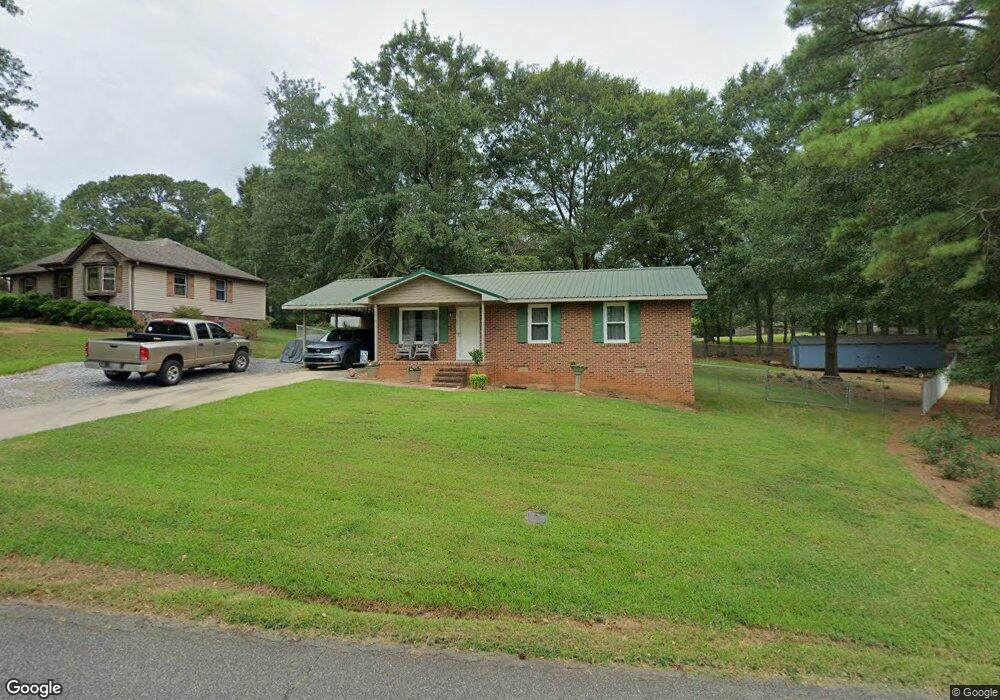
1010 McFalls Cir Anderson, SC 29621
Estimated Value: $146,000 - $200,000
3
Beds
1
Bath
1,050
Sq Ft
$166/Sq Ft
Est. Value
About This Home
This home is located at 1010 McFalls Cir, Anderson, SC 29621 and is currently estimated at $174,490, approximately $166 per square foot. 1010 McFalls Cir is a home located in Anderson County with nearby schools including Nevitt Forest Elementary School, Glenview Middle School, and T.L. Hanna High School.
Ownership History
Date
Name
Owned For
Owner Type
Purchase Details
Closed on
Jul 30, 2020
Sold by
Chapman Derrill C and Chapman Joyce E
Bought by
Lollis Robert M
Current Estimated Value
Home Financials for this Owner
Home Financials are based on the most recent Mortgage that was taken out on this home.
Original Mortgage
$598,989
Outstanding Balance
$532,326
Interest Rate
3.1%
Mortgage Type
New Conventional
Estimated Equity
-$357,836
Purchase Details
Closed on
Jan 17, 2003
Sold by
Black Marilyn T
Bought by
Randolph Danny L
Purchase Details
Closed on
Jan 16, 2003
Sold by
Bankers Tr Co Of Ca Na
Bought by
Chapman Derrill C
Create a Home Valuation Report for This Property
The Home Valuation Report is an in-depth analysis detailing your home's value as well as a comparison with similar homes in the area
Home Values in the Area
Average Home Value in this Area
Purchase History
| Date | Buyer | Sale Price | Title Company |
|---|---|---|---|
| Lollis Robert M | $98,000 | None Available | |
| Randolph Danny L | $39,500 | -- | |
| Chapman Derrill C | $54,000 | -- |
Source: Public Records
Mortgage History
| Date | Status | Borrower | Loan Amount |
|---|---|---|---|
| Open | Lollis Robert M | $598,989 |
Source: Public Records
Tax History Compared to Growth
Tax History
| Year | Tax Paid | Tax Assessment Tax Assessment Total Assessment is a certain percentage of the fair market value that is determined by local assessors to be the total taxable value of land and additions on the property. | Land | Improvement |
|---|---|---|---|---|
| 2024 | $606 | $4,860 | $480 | $4,380 |
| 2023 | $607 | $4,860 | $480 | $4,380 |
| 2022 | $576 | $4,860 | $480 | $4,380 |
| 2021 | $518 | $3,900 | $300 | $3,600 |
| 2020 | $393 | $4,380 | $450 | $3,930 |
| 2019 | $1,443 | $4,380 | $450 | $3,930 |
| 2018 | $1,425 | $4,380 | $450 | $3,930 |
| 2017 | -- | $4,380 | $450 | $3,930 |
| 2016 | $1,268 | $4,110 | $300 | $3,810 |
| 2015 | $1,278 | $4,110 | $300 | $3,810 |
| 2014 | $1,255 | $4,110 | $300 | $3,810 |
Source: Public Records
Map
Nearby Homes
- 801 McFalls Cir
- 230 Hammond Cir
- 218 Hammond Cir
- Lot 1 Broadway Lake Rd
- 720 Lakeside Dr
- 415 Serena Cir
- 329 McFalls Landing
- 16 Margate Rd
- 112 Linkside Dr
- 106 Linkside Dr
- 103 Gilmer Rd
- Lot 6 High Shoals Rd
- Lot 10 High Shoals Rd
- Lot 9 High Shoals Rd
- Lot 7 High Shoals Rd
- Lot 8 and Lot 9 High Shoals Rd
- Lot 5 High Shoals Rd
- 118 Lakeside Dr
- 516 Lakeside Dr
- 210 King Arthur Dr
- 1010 McFalls Cir
- 1024 McFalls Cir
- 1008 McFalls Cir
- 1025 McFalls Cir
- 62-64 Mc Falls Cir
- 106 Guest Cir
- 1027 McFalls Cir
- 106 Guest Cir
- 1022 McFalls Cir
- 103 Guest Cir
- 1101 McFalls Cir
- 1101 McFalls Cir
- 1 McFalls Cir
- 1104 McFalls Cir
- 110 Guest Cir
- 1207 Broadway Lake Rd
- 1005 McFalls Cir
- 1006 McFalls Cir
- 1004 Mcfall Cir
- 1004 McFalls Cir