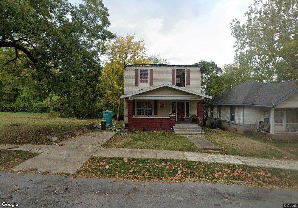
1010 Rice St Little Rock, AR 72202
Central High NeighborhoodEstimated Value: $85,000 - $286,000
--
Bed
3
Baths
1,904
Sq Ft
$78/Sq Ft
Est. Value
About This Home
This home is located at 1010 Rice St, Little Rock, AR 72202 and is currently estimated at $149,070, approximately $78 per square foot. 1010 Rice St is a home located in Pulaski County with nearby schools including M.L. King Elementary School, Dunbar Magnet Middle School, and Central High School.
Ownership History
Date
Name
Owned For
Owner Type
Purchase Details
Closed on
Jan 30, 2023
Sold by
Fresh & Tight Investment Llc
Bought by
Mchugh Timothy J
Current Estimated Value
Purchase Details
Closed on
Apr 2, 2019
Sold by
The Estate Of Robert S Ross
Bought by
Fresh & Tight In Vestments Llc
Purchase Details
Closed on
Jan 31, 2003
Sold by
Carloss Rosie
Bought by
Ross Robert S
Purchase Details
Closed on
May 20, 2002
Sold by
Hocott Joe B and Herrin Patricia R Hocott
Bought by
Carloss Rosie
Create a Home Valuation Report for This Property
The Home Valuation Report is an in-depth analysis detailing your home's value as well as a comparison with similar homes in the area
Home Values in the Area
Average Home Value in this Area
Purchase History
| Date | Buyer | Sale Price | Title Company |
|---|---|---|---|
| Mchugh Timothy J | $15,000 | -- | |
| Fresh & Tight In Vestments Llc | $2,000 | West Little Rock Title Co | |
| Ross Robert S | -- | -- | |
| Carloss Rosie | $14,000 | -- |
Source: Public Records
Tax History Compared to Growth
Tax History
| Year | Tax Paid | Tax Assessment Tax Assessment Total Assessment is a certain percentage of the fair market value that is determined by local assessors to be the total taxable value of land and additions on the property. | Land | Improvement |
|---|---|---|---|---|
| 2025 | $56 | $800 | $800 | -- |
| 2024 | $109 | $1,561 | $800 | $761 |
| 2023 | $109 | $1,561 | $800 | $761 |
| 2022 | $109 | $10,745 | $800 | $9,945 |
| 2021 | $372 | $1,700 | $700 | $1,000 |
| 2020 | $119 | $1,700 | $700 | $1,000 |
| 2019 | $119 | $1,700 | $700 | $1,000 |
| 2018 | $119 | $12,790 | $700 | $12,090 |
| 2017 | $255 | $12,790 | $700 | $12,090 |
| 2016 | $630 | $19,260 | $3,600 | $15,660 |
| 2015 | $556 | $9,367 | $3,600 | $5,767 |
| 2014 | $556 | $7,927 | $3,600 | $4,327 |
Source: Public Records
Map
Nearby Homes
- 0 Rice St Unit 25014406
- 2416 W 13th St
- 923 Booker St
- 1616 Dennison St
- 2211 W 17th St
- 312 Barton St
- 2717 W Capitol Ave
- 1424 Wolfe St
- 1417 Wolfe St
- 1004 Johnson St
- 1609 S Woodrow St
- 216 Rice St
- 1817 S Park St
- 201 Dennison St
- 3224 W 11th St
- 1423 Allis St
- 1504 Bishop St
- 3112 W 16th St
- 3212 Lamar St
- 400 S Booker St
- 1006 Rice St
- 2421 W 10th St
- 1022 Rice St
- 2323 W 10th St
- 1017 Thayer St
- 2324 W 11th St
- 2319 W 10th St
- 2423 W 10th St
- 2318 W 11th St
- W 11th St
- 2315 W 10th St
- 1100 Rice St
- 2312 W 11th St
- 923 Rice St
- 0 Thayer St Unit 16002349
- 0 Thayer St Unit 16004059
- 0 Thayer St Unit 17003744
- 0 Thayer St Unit 17006730
- 0 Thayer St Unit 20028543
- 0 Thayer St Unit 20038922