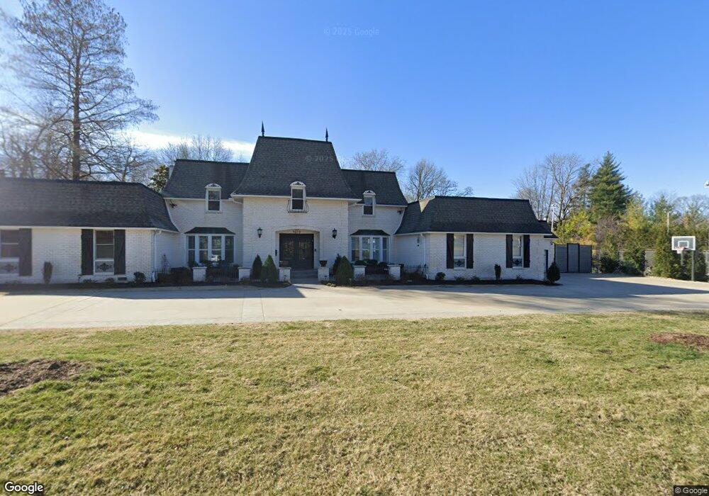
1010 W Laurel Rd Joplin, MO 64801
Roanoke NeighborhoodEstimated Value: $20,000 - $86,000
5
Beds
5
Baths
5,400
Sq Ft
$10/Sq Ft
Est. Value
About This Home
This home is located at 1010 W Laurel Rd, Joplin, MO 64801 and is currently estimated at $53,000, approximately $9 per square foot. 1010 W Laurel Rd is a home located in Jasper County with nearby schools including Columbia Elementary School, North Middle School, and Joplin High School.
Ownership History
Date
Name
Owned For
Owner Type
Purchase Details
Closed on
Mar 13, 2012
Sold by
Adams Stefan W and Adams Kimberly S
Bought by
Satterlee Barrett G and Satterlee Revocable Trust
Current Estimated Value
Purchase Details
Closed on
Dec 13, 2011
Sold by
Lanear Richard E and La Near Ellen A
Bought by
Adams Stefan W and Adams Kimberly S
Purchase Details
Closed on
May 24, 2010
Sold by
Lanear Richard E and Lanear Ellen A
Bought by
Robeson Charles A
Purchase Details
Closed on
Jun 12, 2009
Sold by
Lanear Richard E and Lanear Ellen A
Bought by
Robeson Charles A
Home Financials for this Owner
Home Financials are based on the most recent Mortgage that was taken out on this home.
Original Mortgage
$256,500
Interest Rate
4.7%
Mortgage Type
VA
Create a Home Valuation Report for This Property
The Home Valuation Report is an in-depth analysis detailing your home's value as well as a comparison with similar homes in the area
Home Values in the Area
Average Home Value in this Area
Purchase History
| Date | Buyer | Sale Price | Title Company |
|---|---|---|---|
| Satterlee Barrett G | -- | Fatco | |
| Adams Stefan W | -- | Fatco | |
| Robeson Charles A | -- | Abbey | |
| Robeson Charles A | -- | Abbey |
Source: Public Records
Mortgage History
| Date | Status | Borrower | Loan Amount |
|---|---|---|---|
| Previous Owner | Robeson Charles A | $256,500 |
Source: Public Records
Tax History Compared to Growth
Tax History
| Year | Tax Paid | Tax Assessment Tax Assessment Total Assessment is a certain percentage of the fair market value that is determined by local assessors to be the total taxable value of land and additions on the property. | Land | Improvement |
|---|---|---|---|---|
| 2024 | $142 | $3,080 | $3,080 | -- |
| 2023 | $142 | $3,080 | $3,080 | $0 |
| 2022 | $142 | $3,080 | $3,080 | $0 |
| 2021 | $141 | $3,080 | $3,080 | $0 |
| 2020 | $144 | $3,080 | $3,080 | $0 |
| 2019 | $144 | $3,080 | $3,080 | $0 |
| 2018 | $126 | $2,700 | $0 | $0 |
| 2017 | $126 | $2,700 | $0 | $0 |
| 2016 | $125 | $2,700 | $0 | $0 |
| 2015 | $125 | $2,700 | $0 | $0 |
| 2014 | $125 | $2,700 | $0 | $0 |
Source: Public Records
Map
Nearby Homes
- 915 W Kensington Rd
- 1002 NW Murphy Blvd
- 1232 Bramar Dr
- 1025 Northridge Rd
- 1302 Cambridge Rd
- 629 W Islington Place
- 802 Hampton Place
- 711 N Moffet Ave
- 624 N Sergeant Ave
- 609 N Pearl Ave
- 535 N Byers Ave
- 605 N Pearl Ave
- 428 N Sergeant Ave
- 530 N Pearl Ave
- 411 N Connor Ave
- Lot 3 N Anderson Ave
- Lot 2 N Anderson Ave
- Lot 3 West N Anderson Ave
- Lot 2 West N Anderson Ave
- Lot 1 West N Anderson Ave
- 1015 W Kensington Rd
- 1304 Fairmont Dr
- 1012 W Kensington Rd
- 1030 W Laurel Rd
- 926 W Laurel Rd
- 1008 W Kensington Rd
- 1001 W Laurel Rd
- 1311 Fairmont Dr
- 935 W Kensington Rd
- 1021 W Kensington Rd
- 1016 W Kensington Rd
- 1314 Fairmont Dr
- 1307 Sheridan Dr
- 1317 Sheridan Dr
- 1317 Sheridan Dr Unit 1
- 1020 W Kensington Rd
- 918 W Laurel Rd
- 922 W Kensington Rd
- 1015 Arcadia
- 1304 Crest Dr