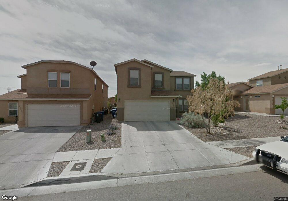
10104 Range Rd SW Albuquerque, NM 87121
Southwest Heights NeighborhoodEstimated Value: $318,000 - $328,000
3
Beds
3
Baths
2,032
Sq Ft
$158/Sq Ft
Est. Value
About This Home
This home is located at 10104 Range Rd SW, Albuquerque, NM 87121 and is currently estimated at $321,683, approximately $158 per square foot. 10104 Range Rd SW is a home located in Bernalillo County with nearby schools including Carlos Rey Elementary School, Atrisco Heritage Academy High School, and Robert F. Kennedy Charter School.
Ownership History
Date
Name
Owned For
Owner Type
Purchase Details
Closed on
Mar 4, 2013
Sold by
Casias Patrick A
Bought by
Casias Patrick A and Casias Santana L
Current Estimated Value
Purchase Details
Closed on
Apr 10, 2007
Sold by
Centex Homes
Bought by
Casias Patrick A
Home Financials for this Owner
Home Financials are based on the most recent Mortgage that was taken out on this home.
Original Mortgage
$177,676
Interest Rate
6.15%
Mortgage Type
FHA
Create a Home Valuation Report for This Property
The Home Valuation Report is an in-depth analysis detailing your home's value as well as a comparison with similar homes in the area
Home Values in the Area
Average Home Value in this Area
Purchase History
| Date | Buyer | Sale Price | Title Company |
|---|---|---|---|
| Casias Patrick A | -- | Accommodation | |
| Casias Patrick A | -- | Commerce Title |
Source: Public Records
Mortgage History
| Date | Status | Borrower | Loan Amount |
|---|---|---|---|
| Previous Owner | Casias Patrick A | $177,676 |
Source: Public Records
Tax History
| Year | Tax Paid | Tax Assessment Tax Assessment Total Assessment is a certain percentage of the fair market value that is determined by local assessors to be the total taxable value of land and additions on the property. | Land | Improvement |
|---|---|---|---|---|
| 2025 | $2,252 | $53,300 | $11,868 | $41,432 |
| 2024 | $2,183 | $51,748 | $11,523 | $40,225 |
| 2023 | $2,147 | $50,240 | $11,187 | $39,053 |
| 2022 | $2,075 | $48,778 | $10,862 | $37,916 |
| 2021 | $2,005 | $47,357 | $10,545 | $36,812 |
| 2020 | $1,972 | $45,978 | $10,238 | $35,740 |
| 2019 | $1,914 | $44,639 | $9,940 | $34,699 |
| 2018 | $1,846 | $44,639 | $9,940 | $34,699 |
| 2017 | $1,789 | $43,340 | $9,651 | $33,689 |
| 2016 | $1,738 | $40,852 | $9,097 | $31,755 |
| 2015 | $39,662 | $39,662 | $8,832 | $30,830 |
| 2014 | $1,700 | $40,029 | $8,832 | $31,197 |
| 2013 | -- | $47,060 | $7,688 | $39,372 |
Source: Public Records
Map
Nearby Homes
- 2408 Sun Gate Trail SW
- 10416 Gila Gulch Rd SW
- 10601 Crandall Rd SW
- 2428 Del Timbre Ln SW
- 1308 Amole Dr SW
- 10643 Four Mile Rd SW
- 9623 El Patron Rd SW
- 10523 Valedon Ln SW
- 2706 Cantara Ln SW
- 10804 Guadiana Place SW
- 2811 Porto St SW
- 2819 Cabernet St SW
- 11024 Bowie Rd SW
- 10505 Tinaja Way SW
- 10513 Tinaja Way SW
- 10517 Tinaja Way SW
- 10525 Tinaja Way SW
- 10521 Tinaja Way SW
- 10529 Tinaja Way SW
- 10500 Tinaja Way SW
- 10108 Range Rd SW
- 10100 Range Rd SW
- 10112 Range Rd SW
- 10116 Range Rd SW
- 10109 Range Rd SW
- 10101 Range Rd SW
- 10105 Range Rd SW
- 10055 Range Rd SW
- 10048 Range Rd SW
- 10115 Range Rd SW
- 10120 Range Rd SW
- 10051 Range Rd SW
- 10044 Range Rd SW
- 10124 Range Rd SW
- 10047 Range Rd SW
- 2100 Lone Draw St SW
- 10123 Range Rd SW
- 10109 Corral Gate Ln SW
- 10101 Corral Gate Ln SW
- 10040 Range Rd SW
Your Personal Tour Guide
Ask me questions while you tour the home.