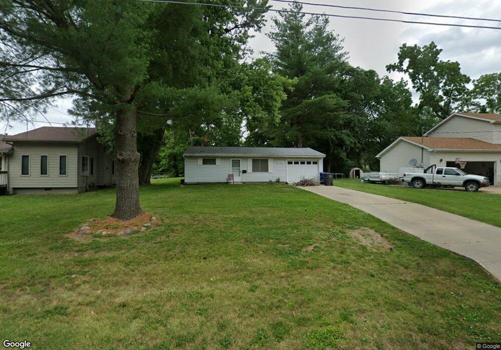
1011 Carrie Ave Des Moines, IA 50315
Watrous South NeighborhoodEstimated Value: $119,000 - $150,000
2
Beds
1
Bath
667
Sq Ft
$197/Sq Ft
Est. Value
About This Home
This home is located at 1011 Carrie Ave, Des Moines, IA 50315 and is currently estimated at $131,141, approximately $196 per square foot. 1011 Carrie Ave is a home located in Polk County with nearby schools including Park Avenue Elementary School, Brody Middle School, and Lincoln High School.
Ownership History
Date
Name
Owned For
Owner Type
Purchase Details
Closed on
Apr 25, 2025
Sold by
Wolinski Anthony P
Bought by
Anthony Peter Wolinski Revocable Trust and Wolinski
Current Estimated Value
Purchase Details
Closed on
May 24, 2004
Sold by
Lapham William G and Lapham Elizabeth A
Bought by
Wolinski Anthony P
Create a Home Valuation Report for This Property
The Home Valuation Report is an in-depth analysis detailing your home's value as well as a comparison with similar homes in the area
Home Values in the Area
Average Home Value in this Area
Purchase History
| Date | Buyer | Sale Price | Title Company |
|---|---|---|---|
| Anthony Peter Wolinski Revocable Trust | -- | None Listed On Document | |
| Anthony Peter Wolinski Revocable Trust | -- | None Listed On Document | |
| Wolinski Anthony P | $59,500 | -- |
Source: Public Records
Tax History Compared to Growth
Tax History
| Year | Tax Paid | Tax Assessment Tax Assessment Total Assessment is a certain percentage of the fair market value that is determined by local assessors to be the total taxable value of land and additions on the property. | Land | Improvement |
|---|---|---|---|---|
| 2025 | $2,146 | $121,800 | $25,700 | $96,100 |
| 2024 | $2,146 | $109,100 | $22,700 | $86,400 |
| 2023 | $2,164 | $109,100 | $22,700 | $86,400 |
| 2022 | $2,148 | $91,800 | $19,300 | $72,500 |
| 2021 | $2,152 | $91,800 | $19,300 | $72,500 |
| 2020 | $2,234 | $86,200 | $18,100 | $68,100 |
| 2019 | $2,050 | $86,200 | $18,100 | $68,100 |
| 2018 | $2,030 | $76,300 | $15,800 | $60,500 |
| 2017 | $1,896 | $76,300 | $15,800 | $60,500 |
| 2016 | $1,848 | $70,100 | $14,200 | $55,900 |
| 2015 | $1,848 | $70,100 | $14,200 | $55,900 |
| 2014 | $1,870 | $70,400 | $14,000 | $56,400 |
Source: Public Records
Map
Nearby Homes
- 4108 SW 12th St
- 1204 Elder Ln
- 4020 SW 12th St
- 1219 Elder Ln
- 1207 Emma Ave
- 930 Emma Ave
- 1109 Herold Ave
- 1222 Watrous Ave
- 1223 Emma Ave
- 1203 Herold Ave
- 1116 Herold Ave
- 4204 SW 7th St
- . Herold Ave
- 3808 SW 12th St
- 3903 SW 9th St
- 606 Marion St
- 936 Mckinley Ave Unit 14
- 3724 SW 13th St
- 1229 Evans St
- 518 Maxwelton Dr
- 1013 Carrie Ave
- 1007 Carrie Ave
- 1005 Carrie Ave
- 1107 Carrie Ave
- 1012 Carrie Ave
- 1008 Carrie Ave
- 1100 Carrie Ave
- 4200 SW 10th St
- 1003 Carrie Ave
- 1112 Carrie Ave
- 1117 Carrie Ave
- 1114 Carrie Ave
- 4102 Glover Ave
- 1001 Carrie Ave
- 4202 SW 10th St
- 1118 Carrie Ave
- 1009 Elder Ln
- 4201 SW 10th St
- 1015 Elder Ln
- 1101 Elder Ln