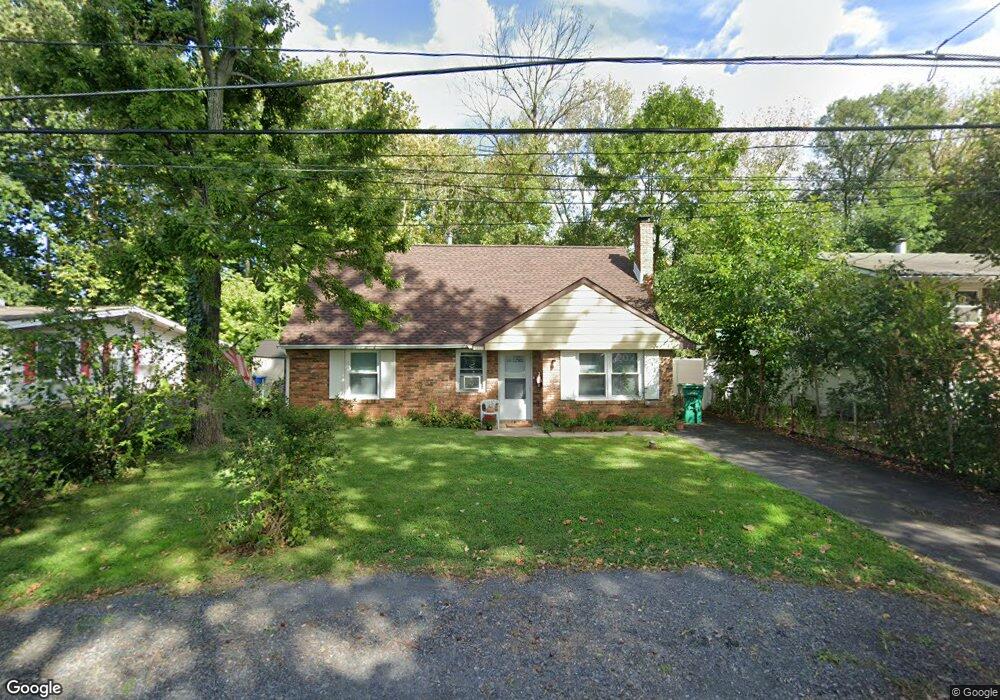
1011 First Ave Croydon, PA 19021
Estimated Value: $345,000 - $383,000
4
Beds
2
Baths
1,440
Sq Ft
$256/Sq Ft
Est. Value
About This Home
This home is located at 1011 First Ave, Croydon, PA 19021 and is currently estimated at $368,984, approximately $256 per square foot. 1011 First Ave is a home located in Bucks County with nearby schools including Truman Senior High School, School Lane Charter School, and St Charles Borromeo School.
Ownership History
Date
Name
Owned For
Owner Type
Purchase Details
Closed on
Aug 8, 2017
Sold by
Delany Elizabeth F and Gaerttner Elizabeth F
Bought by
Delany Elizabeth F
Current Estimated Value
Purchase Details
Closed on
Apr 3, 1984
Sold by
Woodward Harry and Woodward Pauline B
Bought by
Gaerttner Elizabeth F
Create a Home Valuation Report for This Property
The Home Valuation Report is an in-depth analysis detailing your home's value as well as a comparison with similar homes in the area
Home Values in the Area
Average Home Value in this Area
Purchase History
| Date | Buyer | Sale Price | Title Company |
|---|---|---|---|
| Delany Elizabeth F | -- | None Available | |
| Gaerttner Elizabeth F | $49,500 | -- |
Source: Public Records
Tax History
| Year | Tax Paid | Tax Assessment Tax Assessment Total Assessment is a certain percentage of the fair market value that is determined by local assessors to be the total taxable value of land and additions on the property. | Land | Improvement |
|---|---|---|---|---|
| 2025 | $4,997 | $18,400 | $1,640 | $16,760 |
| 2024 | $4,997 | $18,400 | $1,640 | $16,760 |
| 2023 | $4,960 | $18,400 | $1,640 | $16,760 |
| 2022 | $4,960 | $18,400 | $1,640 | $16,760 |
| 2021 | $4,960 | $18,400 | $1,640 | $16,760 |
| 2020 | $4,960 | $18,400 | $1,640 | $16,760 |
| 2019 | $4,942 | $18,400 | $1,640 | $16,760 |
| 2018 | $4,862 | $18,400 | $1,640 | $16,760 |
| 2017 | $4,788 | $18,400 | $1,640 | $16,760 |
| 2016 | $4,788 | $18,400 | $1,640 | $16,760 |
| 2015 | $3,440 | $18,400 | $1,640 | $16,760 |
| 2014 | $3,440 | $18,400 | $1,640 | $16,760 |
Source: Public Records
Map
Nearby Homes
- 1034 Second Ave
- 909 Third Ave
- 805 State Rd
- 813 Fifth Ave
- 709 Shadyside Ave
- 618 Cedar Ave
- 730 Excelsior Ave
- 530 Main Ave
- 601 Fourth Ave
- 535 Princess Ave
- 910 Magnolia Ave
- 1103 Nancy Dr
- 806 Logan Ave
- 208 Neshaminy Rd
- 2113 Pennsylvania Ave
- 1051 Maple Ave
- 1706 Spencer Dr
- 0 Newportville Rd Unit PABU2115306
- 227 Cliff Ave
- 0 Allen Ave
Your Personal Tour Guide
Ask me questions while you tour the home.