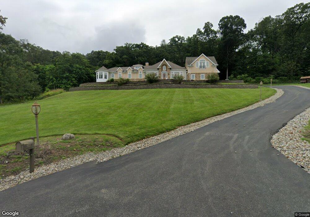
1011 N Mountain Ave Bound Brook, NJ 08805
Estimated Value: $1,324,000 - $1,776,000
5
Beds
5
Baths
5,171
Sq Ft
$286/Sq Ft
Est. Value
About This Home
This home is located at 1011 N Mountain Ave, Bound Brook, NJ 08805 and is currently estimated at $1,479,451, approximately $286 per square foot. 1011 N Mountain Ave is a home located in Somerset County with nearby schools including Crim Primary School, Bridgewater-Raritan Middle School, and Hillside Intermediate School.
Ownership History
Date
Name
Owned For
Owner Type
Purchase Details
Closed on
Jul 10, 2018
Sold by
Papanastasiou Georgia Leontarakis
Bought by
Papanastasiou Georgia Leontarakis
Current Estimated Value
Purchase Details
Closed on
Oct 24, 2008
Sold by
Leontarakis Irene
Bought by
Papanastasiou Georgia
Create a Home Valuation Report for This Property
The Home Valuation Report is an in-depth analysis detailing your home's value as well as a comparison with similar homes in the area
Home Values in the Area
Average Home Value in this Area
Purchase History
| Date | Buyer | Sale Price | Title Company |
|---|---|---|---|
| Papanastasiou Georgia Leontarakis | -- | None Available | |
| Papanastasiou Georgia | $350,000 | None Available |
Source: Public Records
Tax History
| Year | Tax Paid | Tax Assessment Tax Assessment Total Assessment is a certain percentage of the fair market value that is determined by local assessors to be the total taxable value of land and additions on the property. | Land | Improvement |
|---|---|---|---|---|
| 2025 | $22,365 | $1,168,300 | $295,000 | $873,300 |
| 2024 | $22,365 | $1,148,100 | $295,000 | $853,100 |
| 2023 | $20,223 | $1,019,300 | $295,000 | $724,300 |
| 2022 | $18,966 | $919,800 | $295,000 | $624,800 |
| 2021 | $18,626 | $884,000 | $295,000 | $589,000 |
| 2020 | $20,498 | $974,700 | $295,000 | $679,700 |
| 2019 | $20,396 | $960,700 | $295,000 | $665,700 |
| 2018 | $20,134 | $950,600 | $298,800 | $651,800 |
| 2017 | $18,637 | $879,100 | $298,800 | $580,300 |
| 2016 | $18,312 | $877,000 | $298,800 | $578,200 |
| 2015 | $18,084 | $866,500 | $298,800 | $567,700 |
| 2014 | $18,170 | $857,500 | $298,800 | $558,700 |
Source: Public Records
Map
Nearby Homes
- 1058 Shadowlawn Dr Unit 1258
- 24 Dudley Ct
- 112 Wallace Ct Unit 612
- 1108 Shadowlawn Dr Unit 701
- 1108 Shadowlawn Dr
- 3038 King Ct
- 44 Hillcrest Rd
- 8 Juniper Pointe Trail
- 5 Adams Ct
- 1625 King Ct Unit 1625
- 1636 King Ct Unit 1636
- 811 Mountain Ave
- 212 Vesper Ave
- 57 Greenbrook Rd
- 52 Greenbrook Rd
- 28 King George Rd
- 9 Brookside Dr
- 5 Brookside Dr
- 3 Brookside Dr
- 730 Park Ave
- 1001 N Mountain Ave
- 1052 N Mountain Ave
- 990 N Mountain Ave
- 80 Hillcrest Rd
- 981 N Mountain Ave
- 0 Mountain Ave Unit 3462215
- 1010 N Mountain Ave
- 81 Hillcrest Rd
- 980 N Mountain Ave
- 1021 N Mountain Ave
- 971 N Mountain Ave
- 78 Hillcrest Rd
- 1030 N Mountain Ave
- 76 Hillcrest Rd
- 976 N Mountain Ave
- 5 Fawn Ln
- 961 N Mountain Ave
- 0 N Mountain Ave Unit 3266795
- 0 N Mountain Ave Unit 3367264
- 7 Fawn Ln
Your Personal Tour Guide
Ask me questions while you tour the home.