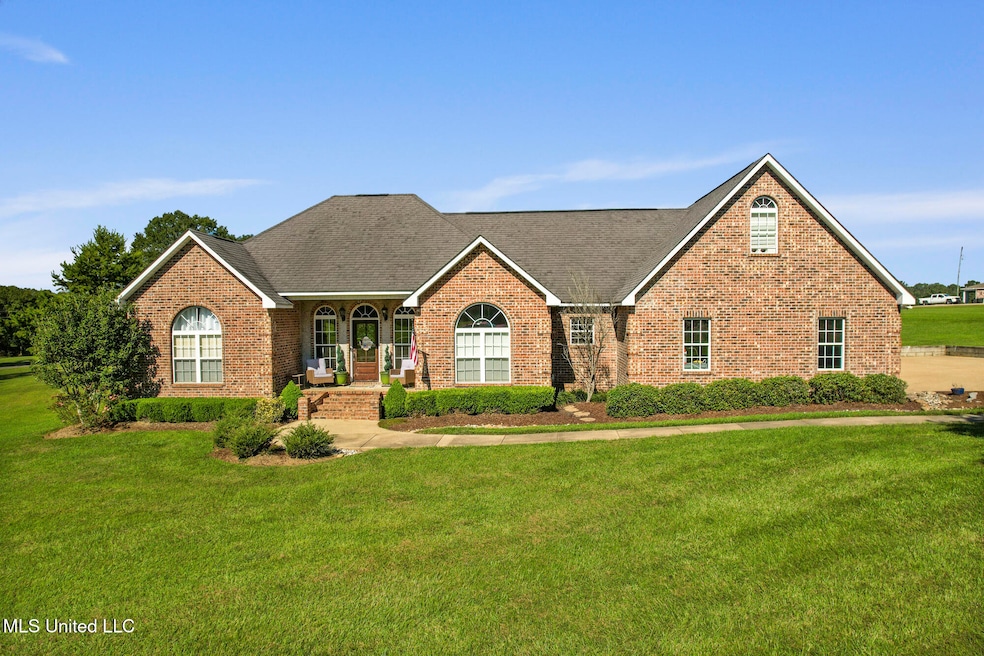
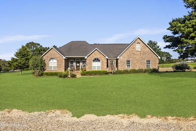
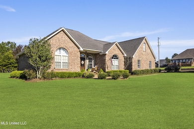
1011 Rolling Oaks Dr McComb, MS 39648
Estimated payment $2,014/month
Highlights
- Deck
- Traditional Architecture
- Attic
- North Pike Elementary School Rated A-
- Main Floor Primary Bedroom
- Granite Countertops
About This Home
Experience the perfect blend of comfort, charm, and space in this stunning four-bedroom, three-and-a-half-bath home, nestled in a quiet subdivision within the sought-after North Pike School District. With approximately 2200 square feet of thoughtfully designed living space on a beautifully manicured 1.73 acre lot, this home offers both privacy and plenty of room for family life.
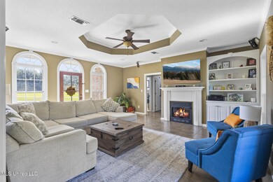
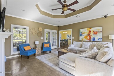
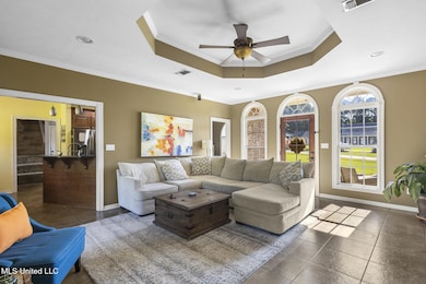
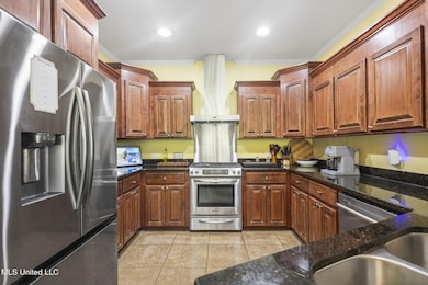
Inside, the living room is flooded with natural light from large windows, creating a warm, inviting atmosphere ideal for relaxing or entertaining. The kitchen is designed for both function and style, with abundant cabinet space, generous counters, and room for casual dining. A dedicated office provides a quiet, convenient space for working from home or studying.
The primary suite is a peaceful retreat with a private bath and ample closet space. Upstairs, a large bedroom and full bath offer flexible options—perfect for guests, a recreation room, or a personal hobby area.
Step outside to enjoy a huge back deck, ideal for morning coffee, summer barbecues, or simply unwinding while overlooking the expansive yard. The property's mature landscaping enhances its serene setting, offering plenty of space for outdoor activities. A two-car garage provides secure parking and storage, and the home is equipped with a security camera system for peace of mind.
This home delivers quiet, country-style living with easy access to excellent schools, shopping, and dining, making it a rare find in the North Pike area. Imagine yourself enjoying the light-filled living spaces, the backyard retreat, and the comfort of a home designed for everyday life—and make it yours today.
Listing Agent
Berkshire Hathaway HomeServices-Cabin & Creek License #B24171 Listed on: 10/06/2025
Home Details
Home Type
- Single Family
Est. Annual Taxes
- $2,685
Year Built
- Built in 2010
Lot Details
- 1.73 Acre Lot
- Landscaped
- Front Yard
Parking
- 2 Car Attached Garage
- Driveway
Home Design
- Traditional Architecture
- Brick Exterior Construction
- Slab Foundation
- Composition Roof
Interior Spaces
- 2,200 Sq Ft Home
- 2-Story Property
- Built-In Features
- Crown Molding
- Tray Ceiling
- Ceiling Fan
- Gas Fireplace
- Home Security System
- Attic
Kitchen
- Free-Standing Gas Oven
- Microwave
- Granite Countertops
Flooring
- Carpet
- Tile
Bedrooms and Bathrooms
- 4 Bedrooms
- Primary Bedroom on Main
- Walk-In Closet
- Soaking Tub
Laundry
- Laundry Room
- Laundry on main level
- Washer and Electric Dryer Hookup
Outdoor Features
- Deck
- Front Porch
Utilities
- Cooling System Powered By Gas
- Central Heating and Cooling System
- Septic Tank
Community Details
- No Home Owners Association
- Rolling Oaks Subdivision
Listing and Financial Details
- Assessor Parcel Number 801255-T
Map
Home Values in the Area
Average Home Value in this Area
Tax History
| Year | Tax Paid | Tax Assessment Tax Assessment Total Assessment is a certain percentage of the fair market value that is determined by local assessors to be the total taxable value of land and additions on the property. | Land | Improvement |
|---|---|---|---|---|
| 2025 | $2,685 | $25,390 | $0 | $0 |
| 2024 | $2,685 | $21,728 | $0 | $0 |
| 2023 | $2,620 | $21,728 | $0 | $0 |
| 2022 | $2,579 | $21,728 | $0 | $0 |
| 2021 | $2,572 | $21,728 | $0 | $0 |
| 2020 | $2,601 | $21,857 | $0 | $0 |
| 2019 | $2,530 | $21,857 | $0 | $0 |
| 2018 | $2,512 | $21,857 | $0 | $0 |
| 2017 | $2,452 | $21,857 | $0 | $0 |
| 2016 | $2,129 | $21,857 | $0 | $0 |
| 2015 | $1,991 | $21,104 | $0 | $0 |
| 2014 | -- | $21,104 | $0 | $0 |
| 2013 | -- | $21,104 | $0 | $0 |
Property History
| Date | Event | Price | List to Sale | Price per Sq Ft |
|---|---|---|---|---|
| 10/06/2025 10/06/25 | For Sale | $340,000 | -- | $155 / Sq Ft |
Purchase History
| Date | Type | Sale Price | Title Company |
|---|---|---|---|
| Quit Claim Deed | -- | Mcneil Law Office Pllc | |
| Warranty Deed | -- | None Available |
Mortgage History
| Date | Status | Loan Amount | Loan Type |
|---|---|---|---|
| Previous Owner | $226,777 | New Conventional |
Source: MLS United
MLS Number: 4127881
APN: 801255-T
Disclaimer: Certain information contained herein is derived from information provided by parties other than Homes.com. All information provided is deemed reliable, but is not guaranteed to be accurate and should be independently verified.
![]() Information is deemed to be reliable but not guaranteed. Copyright 2025 MLS United, LLC.
Information is deemed to be reliable but not guaranteed. Copyright 2025 MLS United, LLC.
- 0 Rolling Oaks Dr
- 1156 Boone Rd
- 1037 Boone Rd
- TBD Hwy 44e
- 2147 McComb Holmesville Rd
- 1022 Friendship Cir
- No Integrity Rd
- 0 Integrity Rd
- 1011 Eastover Ln
- 1041 Van Norman Curve
- 1148 Morgantown Rd
- 1004 Van Norman Curve
- 0 Morgantown Rd Unit 4125975
- 7020 Gibson Rd
- 1019 Pearl River Avenue Extension
- 6121 Gibson Rd
- 1106 Harrison Dr
- XXX Brewer Ln
- 1102 Pearl River Ave
- 1031 Pearl River Ave
- 1013 Bassett Dr Unit D
- 102 N Front St Unit 1
- 420 Howe St
- 516 Northwest Ave
- 509 Maxine Ave Unit A
- 840 Marion Ave
- 1029 Antler Ln
- 403 S Laurel St
- 1300 14th St
- 1328 Parklane Rd
- 305 Lawrence St Unit F
- 1109 Old Brookhaven Rd
- 1061 Campground Rd
- 2083 Martin Rd
- 2018 Stewart Ln
- 36339 Louisiana 38
- 576 Halbert Heights Rd Unit C8
- 800 Magee Dr
- 416 N Seventh St Unit B
- 26450 Choctaw Rd
