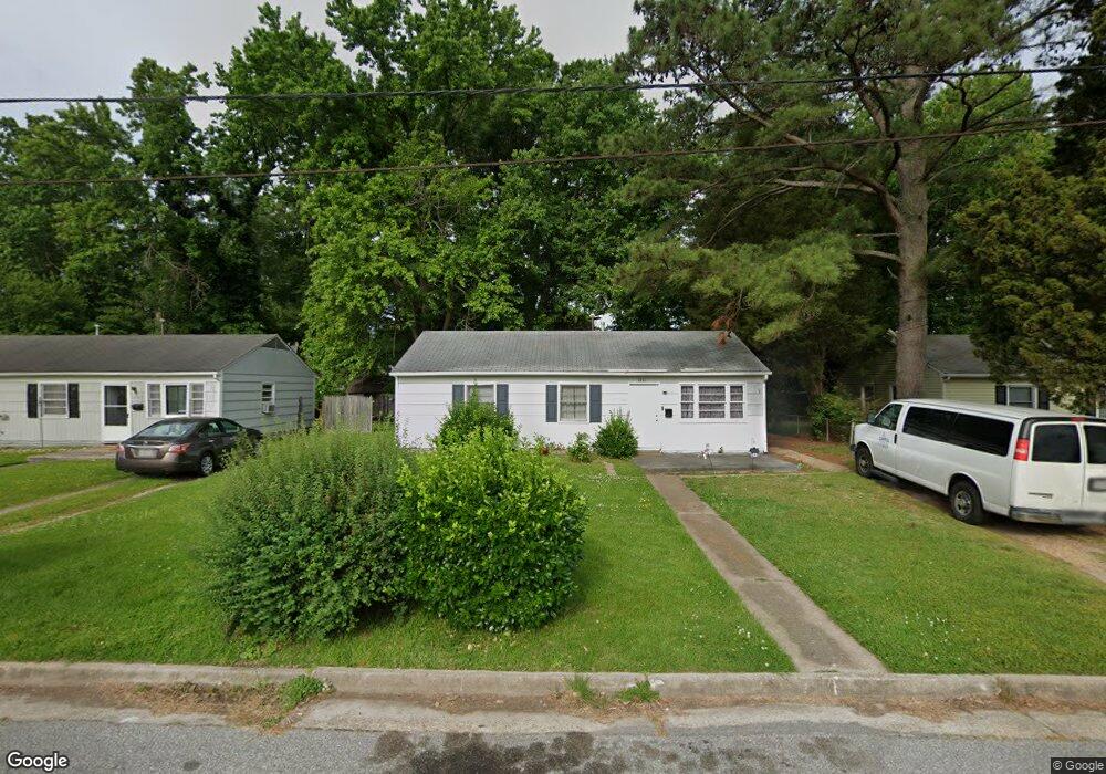
1011 Rollins Cir Hampton, VA 23663
Buckroe Beach NeighborhoodEstimated Value: $199,000 - $229,000
3
Beds
1
Bath
912
Sq Ft
$238/Sq Ft
Est. Value
About This Home
This home is located at 1011 Rollins Cir, Hampton, VA 23663 and is currently estimated at $216,862, approximately $237 per square foot. 1011 Rollins Cir is a home located in Hampton City with nearby schools including Capt. John Smith Elementary School, Benjamin Syms Middle School, and Phoebus High School.
Create a Home Valuation Report for This Property
The Home Valuation Report is an in-depth analysis detailing your home's value as well as a comparison with similar homes in the area
Home Values in the Area
Average Home Value in this Area
Tax History
We collect this data history from publicly available records. To have your information removed, we recommend requesting removal directly through your county’s website.
| Year | Tax Paid | Tax Assessment Tax Assessment Total Assessment is a certain percentage of the fair market value that is determined by local assessors to be the total taxable value of land and additions on the property. | Land | Improvement |
|---|---|---|---|---|
| 2025 | $2,084 | $169,300 | $55,000 | $114,300 |
| 2024 | $1,735 | $150,900 | $55,000 | $95,900 |
| 2023 | $1,564 | $134,800 | $55,000 | $79,800 |
| 2022 | $1,447 | $122,600 | $50,000 | $72,600 |
| 2021 | $1,433 | $105,100 | $42,000 | $63,100 |
| 2020 | $1,205 | $97,200 | $38,300 | $58,900 |
| 2019 | $1,208 | $97,400 | $38,300 | $59,100 |
| 2018 | $1,294 | $96,800 | $38,300 | $58,500 |
| 2017 | $1,294 | $0 | $0 | $0 |
| 2016 | $1,294 | $96,800 | $0 | $0 |
| 2015 | $1,294 | $0 | $0 | $0 |
| 2014 | $1,397 | $96,800 | $38,300 | $58,500 |
Source: Public Records
Map
Nearby Homes
- 1003 Rollins Cir
- 807 Morris St
- 304 Woodland Rd
- 1477 Morgan Dr
- 1521 Morgan Dr
- 1532 Adams Cir
- 617 Renn Rd
- 637 Grimes Rd
- 1607 Grimes Rd
- 531 Price St
- 1508 Hastings Dr
- 1452 E Pembroke Ave
- 2006 Andrews Blvd
- 445 Smiley Rd
- 2102 Grimes Rd
- 1903 Seward Dr
- 55 Calhoun St
- 442 Smiley Rd
- 125 Cambridge Place
- 187 Loch Cir
- 1007 Rollins Cir
- 1009 Rollins Cir
- 1005 Rollins Cir
- 12 Miranda Ct
- 10 Miranda Ct
- 14 Miranda Ct
- 8 Miranda Ct
- 1006 Rollins Cir
- 1004 Rollins Cir
- 1013 Rollins Cir
- 1001 Rollins Cir
- 16 Miranda Ct
- 6 Miranda Ct
- 1801 Bancroft Dr
- 1014 Rollins Cir
- 1015 Rollins Cir
- 4 Miranda Ct
- 1802 Bancroft Dr
- 2 Samantha Ct
- 18 Miranda Ct
Your Personal Tour Guide
Ask me questions while you tour the home.